Archeological Site No. 39HE331

Last updated

Archeological Site No. 39HE331
Nearest city Holabird, South Dakota
Arealess than one acre
MPS Prehistoric Rock Art of South Dakota MPS
NRHP reference No. 93000793 [1]
Added to NRHPAugust 6, 1993

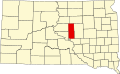
39HE331 is an archaeological rock art site in Hyde County, South Dakota. The art is located on a flat boulder in a field overlooking an intermittent stream near the community of Holabird. The art consists of pecked geometric shapes, including a series of "turkey track" designs, two circles with rays extending from one half, a horseshoe shape, and a plain circle. One of the turkey tracks has an X through it and is surrounded by a circle. The meaning of these symbols is not known, as they do not resemble other rock art in the region. Glacial striations in the boulder surface may also be confused for pecking. [2]

The site was listed on the National Register of Historic Places in 1993, [1] for its potential to yield information about prehistoric Native American movement patterns. [2]

See also

Related Research Articles

<span class="mw-page-title-main">Hueco Tanks</span> United States historic place

Hueco Tanks is an area of low mountains and historic site in El Paso County, Texas, in the United States. It is located in a high-altitude desert basin between the Franklin Mountains to the west and the Hueco Mountains to the east. Hueco is a Spanish word meaning hollows and refers to the many water-holding depressions in the boulders and rock faces throughout the region. Due to the unique concentration of historic artifacts, plants and wildlife, the site is under protection of Texas law; it is a crime to remove, alter, or destroy them.

<span class="mw-page-title-main">Indian Grinding Rock State Historic Park</span> Archaeological site in Amador county, California

Indian Grinding Rock State Historic Park is a California State Park, preserving an outcropping of marbleized limestone with some 1,185 mortar holes—the largest collection of bedrock mortars in North America. It is located in the Sierra Nevada foothills, 8 miles (13 km) east of Jackson. The park is nestled in a little valley 2,400 feet (732 m) above sea level, with open meadows and large specimens of valley oak that once provided the Miwok peoples of this area with an ample supply of acorns. The 135-acre (55 ha) park was established in 1962 and listed on the National Register of Historic Places in 1971.

<span class="mw-page-title-main">National Register of Historic Places listings in North Dakota</span>

There are 461 properties and historic districts listed on the National Register of Historic Places in North Dakota. There are listings in 52 of North Dakota's 53 counties.

<span class="mw-page-title-main">Washington State Park</span>

Washington State Park is a public recreation area covering 2,147 acres (869 ha) in Washington County in the central eastern part of the state of Missouri. It is located on Highway 21 about 14 miles (23 km) northeast of Potosi or 7 miles (11 km) southwest of DeSoto on the eastern edge of the Ozarks. The state park is noted for its Native American rock carvings and for its finely crafted stonework from the 1930s.

<span class="mw-page-title-main">Millstone Bluff</span> Archaeological site in Illinois, United States

Millstone Bluff is a natural bluff in Pope County, Illinois, United States, located near the community of Glendale. Listed on the National Register of Historic Places because of its archaeological significance, Millstone Bluff is one of three National Register sites in Pope County, along with the Golconda Historic District and part of the Kincaid Mounds State Historic Site.

<span class="mw-page-title-main">Fallen Timbers Battlefield</span> United States historic place

The Fallen Timbers Battlefield was the site of the Battle of Fallen Timbers on 20 August 1794. The battle, a decisive American victory over Native American and British opponents, effectively ended the Northwest Indian War, securing the Old Northwest for settlement. An area believed to be the battle site, located in Maumee, Ohio, was declared a National Historic Landmark in 1960. That site, now the Fallen Timbers State Memorial, is about 0.25 miles (0.40 km) south of the actual battlefield, which was identified in 1995, and much of which is now preserved as part of the Fallen Timbers Battlefield and Fort Miamis National Historic Site along with Fort Miami. The National Historic Site was established in 1999 as a partnership between the National Park Service, Toledo MetroParks, and the Ohio Historical Society.

<span class="mw-page-title-main">Arzberger site</span> United States historic place

The Arzberger site, designated by archaeologists with the Smithsonian trinomial 39HU6, is a major archaeological site in Hughes County, near Pierre, South Dakota. It was declared a National Historic Landmark in 1964. It is a large fortified village, that is the type site for the Initial Coalescent, a culture that flourished in the area c. 1200-1350 CE.

<span class="mw-page-title-main">Bloom Site</span> United States historic place

The Bloom Site, designated by the Smithsonian trinomial 39HS1, is an archaeological site in Hanson County, South Dakota. It was declared a National Historic Landmark in 1964.

<span class="mw-page-title-main">National Register of Historic Places listings in Custer County, South Dakota</span>

This is a list of the National Register of Historic Places listings in Custer County, South Dakota.

<span class="mw-page-title-main">National Register of Historic Places listings in Butte County, South Dakota</span>

This is a list of the National Register of Historic Places listings in Butte County, South Dakota.

<span class="mw-page-title-main">National Register of Historic Places listings in Dewey County, South Dakota</span>

This is a list of the National Register of Historic Places listings in Dewey County, South Dakota.

<span class="mw-page-title-main">National Register of Historic Places listings in Hyde County, South Dakota</span>

This is a list of the National Register of Historic Places listings in Hyde County, South Dakota.

<span class="mw-page-title-main">Indian God Rock</span> United States historic place

Indian God Rock is a large boulder in the northwestern part of the U.S. state of Pennsylvania. Located near the unincorporated community of Brandon, it lies along the Allegheny River in Venango County's Rockland Township. It is significant for the large petroglyph on one of its sides. Because of the petroglyph, the rock has been an explorers' landmark, a tourist attraction, and an object of scholarly investigation.

<span class="mw-page-title-main">Francis Farm Petroglyphs</span> United States historic place

The Francis Farm Petroglyphs are a group of petroglyphs in the southwestern part of the U.S. state of Pennsylvania. Located on a boulder in Jefferson Township in the northwestern portion of Fayette County, it has been known to archaeologists since at least the middle of the nineteenth century. Despite damage in the 1930s, it remains an important archaeological site, and accordingly, it has been designated a historic site.

<span class="mw-page-title-main">Judaculla Rock</span> United States historic place

Judaculla Rock is a curvilinear-shaped outcrop of soapstone known for its ancient carvings and petroglyphs. The archaeological site is located on a 0.85-acre rectangular-shaped property, now owned by Jackson County. It is approximately 60 meters east of Caney Fork Creek, a major branch of the northwestward-trending Tuckasegee River in the mountains of Western North Carolina.

<span class="mw-page-title-main">Custer Military Trail Historic Archaeological District</span> Historic district in North Dakota, United States

The Custer Military Trail Historic Archeological District is a national historic district consisting of 18,149 acres (7,345 ha) located in Billings and Golden Valley Counties in North Dakota. The district includes five historic sites associated with the Plains Indian War from 1864 to 1876.

<span class="mw-page-title-main">Paleontology in South Dakota</span>

Paleontology in South Dakota refers to paleontological research occurring within or conducted by people from the U.S. state of South Dakota. South Dakota is an excellent source of fossils as finds have been widespread throughout the state. During the early Paleozoic era South Dakota was submerged by a shallow sea that would come to be home to creatures like brachiopods, cephalopods, corals, and ostracoderms. Local sea levels rose and fall during the Carboniferous and the sea left completely during the Permian. During the Triassic, the state became a coastal plain, but by the Jurassic it was under a sea where ammonites lived. Cretaceous South Dakota was also covered by a sea that was home to mosasaurs. The sea remained in place after the start of the Cenozoic before giving way to a terrestrial mammal fauna including the camel Poebrotherium, three-toed horses, rhinoceroses, saber-toothed cat, and titanotheres. During the Ice Age glaciers entered the state, which was home to mammoths and mastodons. Local Native Americans interpreted fossils as the remains of the water monster Unktehi and used bits of Baculites shells in magic rituals to summon buffalo herds. Local fossils came to the attention of formally trained scientists with the Lewis and Clark Expedition. The Cretaceous horned dinosaur Triceratops horridus is the South Dakota state fossil.

<span class="mw-page-title-main">Petroglyph Canyon</span> United States historic place

Petroglyph Canyon (24CB601) is an archaeologically significant canyon in the northwestern United States. Located on both sides of the border between Montana and Wyoming, the canyon has long been obscure due to its small size. However, it gained substantial attention in the late 20th century because of its numerous prehistoric petroglyphs, and much of it was named a historic site in the 1970s.

39MP3 is an archaeological site in McPherson County, South Dakota. It consists of a panel of rock art, on which designs have been pecked. The designs on this panel appear to resemble heads of bison, a theme echoed in other rock art panels in the area.

References

  1. 1 2 "National Register Information System". National Register of Historic Places . National Park Service. July 9, 2010.
  2. 1 2 Sundstrom, Linea (1993). National Register nomination for 39HE331; available by request from the National Park Service