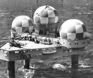
Texas Towers were a set of three radar facilities off the eastern seaboard of the United States which were used for surveillance by the United States Air Force during the Cold War. Modeled on the offshore oil drilling platforms first employed off the Texas coast, they were in operation from 1958 to 1963. After the collapse of one of the towers in 1961, the remaining towers were closed due to changes in threat perception and out of a concern for the safety of the crews.

A radome is a structural, weatherproof enclosure that protects a radar antenna. The radome is constructed of material transparent to radio waves. Radomes protect the antenna from weather and conceal antenna electronic equipment from view. They also protect nearby personnel from being accidentally struck by quickly rotating antennas.

The Distant Early Warning Line, also known as the DEW Line or Early Warning Line, was a system of radar stations in the northern Arctic region of Canada, with additional stations along the north coast and Aleutian Islands of Alaska, in addition to the Faroe Islands, Greenland, and Iceland. It was set up to detect incoming bombers of the Soviet Union during the Cold War, and provide early warning of any sea-and-land invasion.

The RCA 474L Ballistic Missile Early Warning System was a United States Air Force Cold War early warning radar, computer, and communications system, for ballistic missile detection. The network of twelve radars, which was constructed beginning in 1958 and became operational in 1961, was built to detect a mass ballistic missile attack launched on northern approaches [for] 15 to 25 minutes' warning time also provided Project Space Track satellite data.
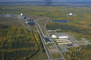
Clear Space Force Station is a United States Space Force radar station for detecting incoming ICBMs and submarine-launched ballistic missiles to NORAD's command center and to provide Space Surveillance data to the United States Space Force. Clear's AN/FPS-123 Upgraded Early Warning Radar is part of the Solid State Phased Array Radar System (SSPARS) which also includes those at Beale AFB, Cape Cod Space Force Station, RAF Fylingdales and Thule Site J. The "historic property" was one of the Alaska World War II Army Airfields and later a Cold War BMEWS site providing NORAD data to Colorado's BMEWS Central Computer and Display Facility (CC&DF).

The AN/FPS-117 is an L-band active electronically scanned array (AESA) 3-dimensional air search radar first produced by GE Aerospace in 1980 and now part of Lockheed Martin. The system offers instrumented detection at ranges on the order of 200 to 250 nautical miles and has a wide variety of interference and clutter rejection systems.
The AN/FPS-35 frequency diversity radar was a long range search radar used in the early 1960s. It was one of the largest air defense radars ever produced, with its antenna and supporting structure mounted on one of the largest rolling-element bearings in the world.
Mount Hebo Air Force Station is a closed United States Air Force General Surveillance Radar station. It is located 5.2 miles (8.4 km) east-southeast of Hebo, Oregon, located at the top of 3,154-foot (961 m) Mount Hebo. It was closed in 1980.

The 689th Radar Squadron is an inactive United States Air Force unit. It was last assigned to the 25th Air Division, stationed at Mount Hebo Air Force Station, Oregon. It was inactivated on 30 June 1979.
Ground Equipment Facility J-33 is a Federal Aviation Administration (FAA) radar station of the Joint Surveillance System's Western Air Defense Sector (WADS) with an Air Route Surveillance Radar (ARSR-4). The facility was previously a USAF general surveillance radar station during the Cold War.

Ground Equipment Facility QRC is an FAA radar station that was part of a Cold War SAGE radar station for aircraft control and warning "from Massachusetts to southern Virginia, and as far out to sea as possible." Benton AFS was also the first operational "regional data processing center" for the GE 477L Nuclear Detection and Reporting System.
The SAGE radar stations of Air Defense Command were the military installations operated by USAF squadrons using the 1st automated air defense environment and networked by the SAGE System, a computer network. Most of the radar stations used the Burroughs AN/FST-2 Coordinate Data Transmitting Set (CDTS) to automate the operator environment and provide radar tracks to sector command posts at SAGE Direction Centers (DCs), e.g., the Malmstrom Z-124 radar station was co-located with DC-20. The sector/division radar stations were networked by DCs and Manual Control Centers to provide command, control, and coordination for ground-controlled interception of enemy aircraft by interceptors such as the F-106 developed to work with the SAGE System.
The AN/FPS-8 Radar was a Medium-Range Search Radar used by the United States Air Force Air Defense Command.

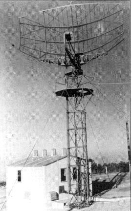
The AN/FPS-20 was a widely used L band early warning and ground-controlled interception radar system employed by the United States Air Force Air Defense Command, the NORAD Pinetree Line in Canada, the USAF CONAD in the continental United States, and a variety of other users. The design started life as the Bendix AN/FPS-3 in 1950, was upgraded to the FPS-20, then spawned over a dozen different variants as additional upgrades were applied. The FPS-20 formed the backbone of the US air defense network through the early Cold War with over 200 units deployed. Most FPS-20 sites were replaced by modern equipment in the late 1960s, although a number were turned over to the FAA, modified for air traffic control use, and became ARSR-60s.
The Avco AN/FPS-26 Radar was an Air Defense Command height finder radar developed in the Frequency Diversity Program with a tunable 3-cavity power klystron for electronic counter-countermeasures (e.g. to counter jamming). Accepted by the Rome Air Development Center on 20 January 1960 for use at SAGE radar stations, the AN/FPS-26 processed height-finder requests (e.g., from Air Defense Direction Centers) by positioning to the azimuth of a target aircraft using a high-pressure hydraulic drive, then "nodding" in either a default automatic mode or by operator command. The inflatable radome required a minimum pressure to prevent contact with the antenna which would result in damage to both (technicians accessed the antenna deck via an air lock.) To maintain high dielectric strength, the waveguide was pressurized with sulfur hexafluoride (SF6), which technicians were warned would produce deadly fluorine if waveguide arcing occurred.

The AN/FPS-4 Radar was a Height-Finder Radar used by the United States Air Force Air Defense Command.
Ground Equipment Facility J-36A is a Federal Aviation Administration (FAA) radar station of the Joint Surveillance System (JSS) in the Western Air Defense Sector (WADS) of NORAD.

The Fort Heath radar station was a USAF radar site and US Army Missile Master installation of the joint-use site system (JUSS) for North American Air Defense at a former coastal defense site. The Cold War radar station had 2 USAF AN/FPS-6B height finding radars, 2 Army AN/FPS-6A height finders, an FAA ARSR-1 radar emplaced 1958-9, and an Army nuclear bunker. Arctic Towers were the pedestals for the FPS antennas and radomes, while the Air Route Surveillance Radar was on a 50-foot extension temperate tower adjacent to the Federal Aviation Administration building.

A radar tower is a tower whose function is to support a radar facility, usually a local airport surveillance radar, and hence often at or in the vicinity of an airport or a military air base. In addition, radar towers are used for the installation and operation of search and height finder radars at military radar stations where the mission is to support air defense missions. These missions were characterized as Aircraft Control & Warning (AC&W) or Long Range Surveillance in support of the Semi-automatic Ground Environment (SAGE).

The Saugatuck Gap Filler Annex is a decommissioned radar installation that once served in the vast Cold War era Semi-Automatic Ground Environment (SAGE) air defense system. Of the hundreds of SAGE radars, Saugatuck's is one of, perhaps, two that remain nearly completely intact.