Related Research Articles

The M90 is a motorway in Scotland. It runs from Junction 1A of the M9 motorway, south of the Queensferry Crossing, to Perth. It is the northernmost motorway in the United Kingdom. The northern point goes to the western suburbs of Perth at Broxden. A small part of the M90 was originally numbered as the M85 motorway.

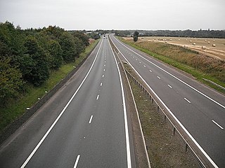
The M80 is a motorway in Scotland's central belt, running between Glasgow and Stirling via Cumbernauld and Denny and linking the M8, M73 and M9 motorways. Following completion in 2011, the motorway is 25 miles (40 km) long. Despite being only a two lane motorway, parts of the M80 Stepps Bypass are used by around 60,000 vehicles per day.
The M876 motorway is a motorway in Scotland. The motorway runs from Denny to Airth in the Falkirk council area, forming an approach road to the Kincardine Bridge. It was opened in 1980.

The River Leven is a stretch of water in West Dunbartonshire, Scotland, flowing from Loch Lomond in the North to the River Clyde in the South. The river is about 6 miles long. It is very popular with salmon and sea trout anglers, trying to catch one of these migratory fish going up to Loch Lomond.

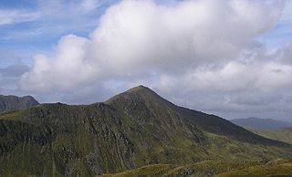
Beinn Ìme is the highest mountain in the Arrochar Alps of Argyll, in the Southern Highlands of Scotland. It reaches 1,011 metres (3,317 ft), making it a Munro.
Ben Vorlich is a mountain in the Southern Highlands of Scotland. It lies south of Loch Earn and Ardvorlich, and a short distance north of the neighbouring mountain Stùc a' Chroin. Ben Vorlich reaches a height of 985 metres (3,232 ft), making it a Munro.
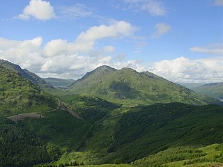
Beinn an Lochain is a mountain in the Arrochar Alps, southern Scotland, on the western edge of Loch Lomond and the Trossachs National Park. Although included in Sir Hugh Munro's original list of Scottish mountains over 3000 feet, subsequent surveys showed it to be significantly shorter than the 914.4 m cut-off limit required to count as a Munro. Nonetheless, it remains a popular mountain, and is often quoted as an example of an interesting mountain below 3000 feet to show that there is more to mountaineering in Scotland than just Munro-bagging.
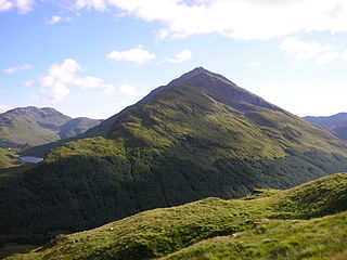
Ben Vorlich is a mountain in the Arrochar Alps of Argyll, in the Southern Highlands of Scotland. It reaches 943 metres (3,094 ft), making it a Munro. It lies between Loch Lomond and Loch Sloy. Ben Vorlich is the highest point of the historic county of Dunbartonshire.
Strathallan is the strath of the Allan Water in Scotland. The strath stretches north and north-east from Stirling through Bridge of Allan, Dunblane and Blackford to Auchterarder in Perth and Kinross.

The Central Lowlands, sometimes called the Midland Valley or Central Valley, is a geologically defined area of relatively low-lying land in southern Scotland. It consists of a rift valley between the Highland Boundary Fault to the north and the Southern Uplands Fault to the south. The Central Lowlands are one of the three main geographical sub-divisions of Scotland, the other two being the Highlands and Islands which lie to the north, northwest and the Southern Uplands, which lie south of the associated second fault line. It is the most populated of Scotland’s three geographical regions.

Meall a' Bhùiridh (IPA:[ˈmauɫ̪ˈaˈvuːɾʲɪʝ]) is a mountain on the edge of Rannoch Moor in the Highlands of Scotland. It lies near the top of Glen Coe and Glen Etive, overlooking the Kings House Hotel inn and the A82 road. The Glencoe Ski area is located on the northern slopes of the peak.

The A81 road is a major road in Scotland. It runs from Glasgow to Callander via Woodside and Maryhill within the city, as well as Bearsden, Milngavie and Strathblane, a total of 30 miles (48 km).
Dundee Violet Football Club are a Scottish football club based in the city of Dundee. Members of the Scottish Junior Football Association, they currently play in the East Region North Division. Formed in 1883, their home ground is Glenesk Park and the club colours are royal blue.
Glen Dochart in Perthshire, Scottish Highlands is a glen which runs from Crianlarich eastwards to Killin, following the course of the River Dochart as it flows through Loch Dochart and Loch Iubhair. It is met by Glen Ogle at Lix Toll. Lochan Saorach lies within the glen and was once famous for its Floating island.
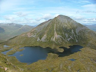
Sgùrr Eilde Mòr or Sgùrr Èilde Mhòr is a mountain in the Mamores range of the Grampian Mountains, Scotland. It is 6 kilometres north-east of Kinlochleven. It is a steep, conical peak of scree and quartzite boulders, capped with a layer of schist. With a height of 1010 m (3314 ft) it is classed as a Munro, so is popular with hillwalkers. It is most commonly climbed from Kinlochleven by way of a stalker's path which leads to a col at Coire an Lochan, and then by either the south or the west ridge - both routes involving an ascent of steep, bouldery terrain.

Beinn Sgulaird or Beinn Sguiliaird is a mountain in the Lorn region of the Scottish Highlands, between Glen Creran and Glen Etive. It has a height of 937 m (3074 ft) and is classed as a Munro. The mountain takes the form of a long ridge which runs from southwest to northeast, three kilometres of which lie above 800 m. Hillwalkers commonly traverse the ridge from north to south, as this gives the best views of the Hebrides to the west, in particular the Isle of Mull. While most walkers start from Glen Creran to the west, an ascent from Glen Etive is also possible.

Beinn a' Chreachain is a Scottish mountain, with a conical top, to the north-west of Loch Lyon.
This is a list of the extreme points and extreme elevations in Scotland.

Robert Burns is a bronze portrait statue of Robert Burns by John Steell. Four versions exist, in New York City, Dundee (Scotland), London (England), and Dunedin.
References
| | This Argyll and Bute location article is a stub. You can help Wikipedia by expanding it. |