
Arenal River is a river of Costa Rica that is a tributary of the San Carlos River. [1] Its upper part is dammed by the Presa Sangregado Dam to form the Lake Arenal.
Arenal River is a river of Costa Rica that is a tributary of the San Carlos River. [1] Its upper part is dammed by the Presa Sangregado Dam to form the Lake Arenal.

Martin Strel, is a Slovenian long-distance swimmer, one of the most elite endurance athletes best known for swimming the entire length of various rivers. Strel holds successive Guinness World Records for swimming the Danube river, the Mississippi River, the Yangtze River, and the Amazon River. His motto is "swimming for peace, friendship and clean waters."

Arenal Volcano is an active andesitic stratovolcano in north-western Costa Rica around 90 km (56 mi) northwest of San José, in the province of Alajuela, canton of San Carlos, and district of La Fortuna. The Arenal volcano measures at least 1,633 metres (5,358 ft) high. It is conically shaped with a crater 140 metres (460 ft) in diameter. Geologically, Arenal is considered a young volcano and it is estimated to be less than 7,500 years old. It is also known as "Pan de Azúcar", "Canaste", "Volcan Costa Rica", "Volcan Río Frío" or "Guatusos Peak".
Arenal may refer to:

Alajuela is a province of Costa Rica. It is located in the north-central part of the country, bordering Nicaragua to the north. It also borders the provinces of Heredia to the east, San José to the south, Puntarenas to the southwest and Guanacaste to the west. As of 2011, the province had a population of 885,571. Alajuela is composed of 16 cantons, which are divided into 111 districts. It covers an area of 9,757.53 square kilometers.

Lake Arenal is a lake in the northern highlands of Costa Rica. It is the largest lake in Costa Rica at 85-square-kilometre (33 sq mi). Its depth varies between 30 and 60 meters (100–200 feet) seasonally.
Soyapango is a district in the San Salvador department of El Salvador. Soyapango is the country's largest municipality with 284,700 residents. Soyapango is a satellite city of San Salvador and it is the main thoroughfare between San Salvador and the eastern part of the country, and nearly 70,000 vehicles travel through it every day. The nickname for this satellite city is Soya.
El Paraíso is a district in the Chalatenango Department of El Salvador. Settlements of El Paraíso include Calle Nueva, Coyotera, El Arenal, El Desvío, El Tamarindo, La Angostura, and Santa Bárbara. El Paraíso has two rivers: El Río Grande, and El Río de la Arenal.

The Cordillera de Guanacaste, also called Guanacaste Cordillera, are a volcanic mountain range in northern Costa Rica near the border with Nicaragua. The mountain range stretches 110 km from northwest to the southeast and contains mostly complex stratovolcanoes. The range forms part of the southern region of the Continental Divide, with the highest peak is the stratovolcano Miravalles at 2,028 m.

Arenal Tempisque Conservation Area, is an administrative area which is managed by SINAC for the purposes of conservation in the northwest part of Costa Rica, near the Arenal Volcano and covering part of the Cordillera de Tilarán and Cordillera de Guanacaste. It contains a number of National Parks, Wildlife refuges and Protected Zones. The area was previously known as Arenal Tilarán Conservation Area.

Arenal Volcano National Park is a Costa Rican national park in the central part of the country, part of the Arenal Huetar Norte Conservation Area. The park encompasses the Arenal Volcano, the most active in the country, which was believed to be dormant until a major eruption in 1968. It neighbors Lake Arenal, which is the site of the country's largest hydroelectricity project, the Lake Arenal Dam.

El Arenal is a neighbourhood in the historical centre of Seville, the Casco Antiguo. It lies on the east bank of the Guadalquivir river to the west of the old Jewish Quarter, Santa Cruz, and south of the neighbourhoods of Museo and Alfalfa. Its name comes from the sandy nature that this east bank of the river once used to have. El Arenal has a history characterised by its former position as the port of Seville, until river silting forced the city to relocate the port to the southern edge of the city in the 17th century.

Federico Cantero Villamil was a Spanish civil engineer known for the dams he constructed and planned along the river Duero and for his research on the aeronautical field, which is summarized in the Libélula española, a helicopter constructed by him.

La Fortuna is a district of the San Carlos canton, in the Alajuela province of Costa Rica.
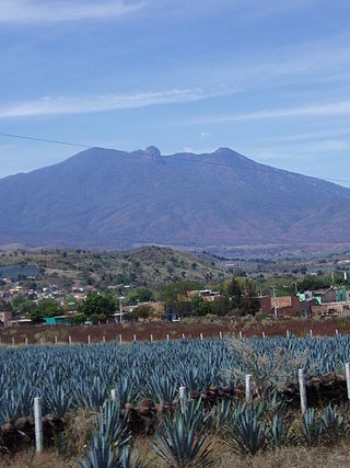
El Arenal is a town and municipality in the state of Jalisco in central-western Mexico. El Arenal is known as the gateway to the so-called "blue agave" region in the Jaliscan Highlands. The municipality has an area of approximately 111.8 square kilometres (43.2 sq mi).

Luis Arenal Bastar was a Mexican painter, engraver and sculptor. He was a founding member of the Liga de Escritores y Artistas Revolucionarios, the Taller de Gráfica Popular and the Salón de la Plástica Mexicana. In addition, he created murals and other monumental works in Mexico City and Guerrero.
Presa Sangregado Dam is a high-earthen hydroelectric dam on the south-east shore of Lake Arenal in the Guanacaste Province of northwest Costa Rica. The dam is 288 feet (88 m) and 184 feet (56 m) high. The installed hydroelectric capacity is 157 megawatts. The hydroelectric power plant is operated by Instituto Costarricense de Electricidad.
Costa Rica is divided into three major drainage basins encompassing 34 watersheds with numerous rivers and tributaries, one major lake used for hydroelectric generation, and two major aquifers that serve to store 90% of the municipal, industrial, and agricultural water supply needs of Costa Rica. Agriculture is the largest water user demanding around 53% of total supplies while the sector contributes 6.5% to the Costa Rica GDP. About a fifth of land under cultivation is being irrigated by surface water. Hydroelectric power generation makes up a significant portion of electricity usage in Costa Rica and much of this comes from the Arenal dam.
The Arenal Prehistory Project was a multidisciplinary research effort taking place between 1984 and 1987 that uncovered evidence of human occupation from Paleoindian and Archaic times through four sedentary phases to the Spanish Conquest in the tropical rainforest of Northwest Costa Rica.

The Arenal Bridge is a reinforced concrete bridge in Bilbao, Spain.

Renewable energy in Costa Rica supplied about 98.1% of the electrical energy output for the entire nation and imported 807000 MWh of electricity in 2016. Fossil fuel energy consumption in Costa Rica was 49.48 as of 2014, with demand for oil increasing in recent years. In 2014, 99% of its electrical energy was derived from renewable energy sources, about 80% of which from hydroelectric power. For the first 75 days of 2015, 100% of its electrical energy was derived from renewable energy sources and in mid 2016 that feat was accomplished for 110 consecutive days despite suboptimal weather conditions.