
Areora is one of four traditional districts on the island of Mauke in the Cook Islands. [1] It is in the south of the island, and is subdivided into three tapere.
Areora is one of four traditional districts on the island of Mauke in the Cook Islands. [1] It is in the south of the island, and is subdivided into three tapere.

The Cook Islands can be divided into two groups: the Southern Cook Islands and the Northern Cook Islands. The country is located in Oceania, in the South Pacific Ocean, about halfway between Hawaii and New Zealand.
Chu Chua Cottonwood Provincial Park is a provincial park in British Columbia, Canada, located 80km north of Kamloops and incorporating a group of forested islands in the floodplain of the North Thompson River.

The Roman Catholic Diocese of Rarotonga in the Cook Islands is a suffragan diocese of the Roman Catholic Archdiocese of Suva in neighbouring Fiji. It was erected as the Prefecture Apostolic of Cook and Manihiki in 1922, elevated to the Vicariate Apostolic of Cook Islands in 1948 and elevated as the Diocese of Rarotonga in 1966.
Rakahanga-Manihiki is a Tahitic language belonging to the Polynesian language family, spoken by about 2500 people on Rakahanga and Manihiki Islands and another 2500 in other countries, mostly New Zealand and Australia. Wurm and Hattori consider Rakahanga-Manihiki as a distinct language with "limited intelligibility with Rarotongan". According to the New Zealand Maori anthropologist Te Rangi Hīroa who spent a few days on Rakahanga in the years 1920, "the language is a pleasing dialect and has closer affinities with [New Zealand] Maori than with the dialects of Tongareva, Tahiti, and the Cook Islands"
Mauke Airport is an airport on Mauke in the Cook Islands.

The Cook Islands Federation was created in 1891, after the Kingdom of Rarotonga was given the island of Aitutaki. It lasted until 1901, when it was given to New Zealand.

Ngatiarua is one of four traditional districts on the island of Mauke in the Cook islands. It is in the north of the island, between the districts of Makatea and Vaimutu, and is subdivided into five or six tapere.
Makatea is one of four traditional districts on the island of Mauke in the Cook islands. It is in the west of the island, between the districts of Areora and Ngatiarua.
Vaimutu is one of four traditional districts on the island of Mauke in the Cook islands. It is in the east of the island, between the districts of Ngatiarua and Areora.
Ngaputoru is the generic name give to the islands of Atiu, Mauke, Mitiaro and Takutea in the Cook Islands archipelago. In the Cook Islands Māori language, the term means "the (nga) roots (pu) three (toru)", or in English "the three roots". Ngaputoru, which is a term used locally, refers to family ties of the ariki (chiefs) of Atiu, Mauke and Mitiaro. The island of Takutea is uninhabited. These islands are in the easternmost part of the Southern Cook Islands.
Mapu Tangatatutai Taia was a Cook Islands politician. He served as Speaker of the Cook Islands Parliament from 2006 to 2010. He was a member of the Cook Islands Democratic Party and held the traditional title of Kakemaunga Mataiapo.
Mauke is a Cook Islands electoral division returning one member to the Cook Islands Parliament. Its current representative is Mapu Taia, who has held the seat since 1999.
Tutai Tura is a Cook Islands politician and former member of the Cook Islands Parliament. Since March 2021 he has been Speaker of the Cook Islands Parliament. He is a member of the Cook Islands Party.

Florida's 27th congressional district is an electoral district for the U.S. Congress and was first created in South Florida during 2012, effective January 2013, as a result of the 2010 census. The first candidates ran in the 2012 House elections, and the winner was seated for the 113th Congress on January 3, 2013.
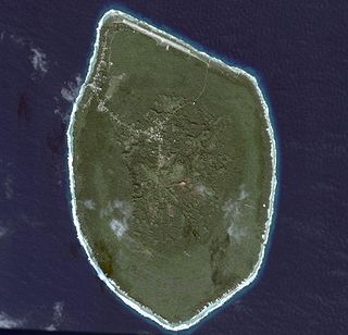
Mauke is an island of the Cook Islands archipelago, lying in the central-southern Pacific Ocean. Part of the Nga-pu-Toru, it is 277 km (172 mi) northeast of Rarotonga.
Renewable energy in the Cook Islands is primarily provided by solar energy and biomass. Since 2011 the Cook Islands has embarked on a programme of renewable energy development to improve its energy security and reduce greenhouse gas emissions, with an initial goal of reaching 50% renewable electricity by 2015, and 100% by 2020. The programme has been assisted by the governments of Japan, Australia, and New Zealand, and the Asian Development Bank.

Arago hotspot is a hotspot in the Pacific Ocean, presently located below the Arago seamount close to the island of Rurutu, French Polynesia.
Tararo Jane Ariki II was a Cook Islands chiefess and politician. An ariki of Mauke island, she was also the first woman to become a member of the islands' Legislative Council.
Kimiangatau is a village on Mauke in the Cook Islands. The village is on the coast, next to the island's main harbour or Taunganui landing place. It was founded in 1904 after animosity between followers of the London Missionary Society and the newly introduced Roman Catholic church.
Oiretumu is a village on Mauke in the Cook Islands. The village is inland, near the centre of the island.
20°10′00″S157°20′30″W / 20.16667°S 157.34167°W
| | This article about an island in the Cook Islands is a stub. You can help Wikipedia by expanding it. |