Arequipa metropolitan area

Last updated
Arequipa Metropolitan Area
CountryFlag of Peru.svg  Peru
Region Arequipa
Province Arequipa Province
Population
 (2007 Census)
  Total 1,034,736 (2,017)
Time zone UTC-5 (PET)

The Arequipa Metropolitan Area is the name used to refer to the metropolitan area whose principal city is Arequipa, according to Metropolitan Development Plan of Arequipa [1] According to population statistics of INEI It is the second most populous metropolitan area of Peru in year 2017.

Contents

Population

Map of Arequipa metropolitan area Arequipa Metropolitana por distritos CMC.png
Map of Arequipa metropolitan area

According to INEI the population of Arequipa metropolitan in the year 2007 was of 899.291 people [2] and according to Metropolitan Development Plan of Arequipa for year 2007 this had 822,479 people distributed in its metropolitan districts. According to the census 2007 and estimated population of INEI In the table is shown the population of Arequipa Metropolitan by districts:

Metropolitan districtsArea
km²
Dwelling
(Census 2007)
Population
minor to 1 year
Density
(pop./km²)*
Elevation media
msl*
Distance
to Arequipa (km) [3]
Population
Census 2007*
Estimated
Population 2015 [4]
Alto Selva Alegre 6.9818,6381,13510,414.92,500572,69682,412
Arequipa 12.8017,0626994,811.82,335061,59154,905
Cayma **246.3120,2671,227303.62,403274,77691,802
Cerro Colorado 174.935,8051,978647.12,4064113,171148,164
Characato 86.03,2869678.22.480106,7269,288
Jacobo Hunter 20.3710,5437242,262.72,268746,09248,326
José Bustamante 10.8318,8061,0707,055.42,310276,41076,711
Mariano Melgar 29.8312,8438721,748.02,385352,14452,667
Miraflores 28.6813,1337421,767.92,430150,70448,677
Mollebaya 36.65882538.52,48371,4101,868
Paucarpata 31.729,3511,9825061.42,4053160,446124,755
Quequeña 34.93--34.92,536-1,2191,376
Sabandía 5371,178566.92,22083,6994,136
Sachaca 36.634,806273478.82,390417,53719,581
Socabaya 18.6416,0698533,201.22,300359,67178,135
Tiabaya 31.623,761247464.22,178814,67714,768
Uchumayo 22.143,280175482.01,9501610,67212,436
Yanahuara 2.26,62621710,404.52,390322,89025,483
Yura 1,942.96,1792738.12,5902816,02025,367
Total3,311.1218,93812,644260.52,3350822,479 [1] 920,857
*Census 2007 - INEI

2017 Census

Metropolitan districtsSurface
km²
Altitude
msnm
Distance to the
Historical Center (km) [3]
Población 2017 [5]
Arequipa 12,82335055 437
Alto Selva Alegre 6,982500585 870
Cayma 246,312403291 935
Cerro Colorado 174,924064197 954
Characato 86,024801012 949
Chiguata 460,812946302939
Jacobo Hunter 20,372268750 164
José Bustamante 10,832310281 829
Mariano Melgar 29,832385359 918
Miraflores 28,682430160 589
Mollebaya 36,6248374756
Paucarpata 31,724053131 346
Quequeña 34,932536-4784
Sabandía 537222084368
Sachaca 36,632390424 225
Socabaya 18,642300375 351
Tiabaya 31,622178816 191
Uchumayo 22,1419501614 054
Yanahuara 2,22390325 417
Yarabamba 492,22474-1314
Yura 1942,925902833 346
Total4264,07--1 034 736
Datos del XII Censo de Población, VII de Vivienda y III de Comunidades Indígenas 2017 [5]

Graphics of evolution of the population

In the following Graphics the evolution of the population of Arequipa metropolitan area.

evolution of the population of Arequipa metropolitan area
Arequipa metropolitan area
Sources:
Population 1940, 1961, 1972, 1981, [6] 1993,2007 [1] Population 2015 [4]

See also

Related Research Articles

<span class="mw-page-title-main">Demographics of Peru</span> Demographics of country

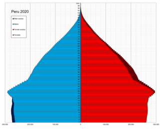
This is a demography of the population of Peru including population density, ethnicity, education level, the health of the populace, economic status, religious affiliations and other aspects of the population.

<span class="mw-page-title-main">Chiclayo</span> Place in Lambayeque, Peru

Chiclayo is the principal city of the Lambayeque region in northern Peru. It is located 13 kilometers inland from the Pacific coast and 770 kilometers from the nation's capital, Lima.

<span class="mw-page-title-main">Arequipa Province</span> Province in Arequipa, Peru

Arequipa is a province in the Arequipa Region, Peru. Its capital, Arequipa, is Peru's third most populous province of Peru. It borders the provinces of Islay, Camaná, Caylloma, and the Cusco and Puno regions. According to INEI in the year 2014 it has a population of 958.351 people.

<span class="mw-page-title-main">Lima metropolitan area</span> Place in Peru

The Lima Metropolitan Area is an area formed by the conurbation of the Peruvian provinces of Lima and Callao. It is the largest of the metropolitan areas of Peru, the seventh largest in the Americas, the fourth largest in Latin America, and among the thirty largest in the world. The conurbation process started to be evident in the 1980s.

<span class="mw-page-title-main">Escazú (canton)</span> Canton in San José province, Costa Rica

Escazú is the second canton in the province of San José in Costa Rica.

<span class="mw-page-title-main">Largest cities in the Americas</span> Wikimedia list article

This is a list of the 50 largest cities in the Americas by population residing within city limits as of 2015, the most recent year for which official population census results, estimates or short-term projections are available for most of these cities. These figures do not reflect the population of the urban agglomeration or metropolitan area which typically do not coincide with the administrative boundaries of the city. For a list of the latter, see List of metropolitan areas in the Americas by population. These figures refer to mid-2015 populations with the following exceptions:

  1. Mexican cities, whose figures derive from the 2015 Intercensal Survey conducted by INEGI with a reference date of 15 March 2015;
  2. Calgary, whose 2015 municipal census had a reference date of April 1.
  3. Brazilian Cities, whose figures originate from the 2021 estimate given by the IBGE, with a reference date of July 1st, 2021.

Orotina is a district of the Orotina canton, in the Alajuela province of Costa Rica.

<span class="mw-page-title-main">Trujillo Province, Peru</span> Province in La Libertad, Peru

Trujillo Province is one of twelve provinces in La Libertad Region in Peru.

Talamanca is a canton in the Limón province of Costa Rica. The head city is Bribri, located in Bratsi district.

<span class="mw-page-title-main">Arequipa</span> Region capital in Peru

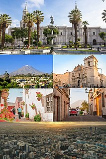
Arequipa is a city and capital of province and the eponymous department of Peru. It is the seat of the Constitutional Court of Peru and often dubbed the "legal capital of Peru". It is the second most populated city in Peru, after Lima, with an urban population of 1,008,290 inhabitants according to the 2017 national census.

The Piura Metropolitan Area is the name used to refer to the metropolitan area whose principal city is Piura, located in northern Peru. According to "Concerted development plan Piura 2009–2014" the districts of Piura, Veintiséis de Octubre, Castilla and Catacaos of Piura Province currently are consolidated into a metropolitan area to act with the same urban, industrial and commercial plan. It is one of the most populous metropolitan area of Peru in year 2015.

The Chiclayo Metropolitan Area is the name used to refer to the metropolitan area whose principal city is Chiclayo, according to Municipality of Chiclayo. According to population statistics of INEI It is the fourth most populous metropolitan area of Peru in year 2015.

<span class="mw-page-title-main">Iquitos metropolitan area</span> Place in Peru

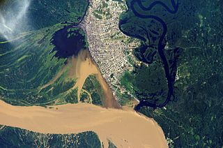
The Iquitos Metropolitan Area is the name used to refer to the Peruvian metropolitan area whose principal city is Iquitos, according to Municipality of Iquitos. According to population statistics of INEI It is the sixth most populous metropolitan area of Peru in year 2015.

References

  1. 1 2 3 "Plan de Desarrollo Metropolitano de Arequipa 2012-2022 (Pag. 34)".
  2. INEI, ed. (2011). "(spanish)INEI:Arequipa Compendio estadístico 2011 - Arequipa Metropolitana, Población censada y estimada, Según Distritos (page 77)" . Retrieved October 25, 2012.
  3. 1 2 Instituto Nacional de Estadística e Informática Distancia y tiempo que hay de la capital distrital a la capital provincial
  4. 1 2 "Perú:Estimaciones y proyecciones de Población Por sexo según Departamento, Provincia y Distrito 2012-2015 - INEI".
  5. 1 2 "Directorio Nacional de Centros Poblados - Censos Nacionales 2017". INEI. Retrieved 10 October 2018.
  6. Municipalidad de Arequipa. "Plan Director de Arequipa Metropolitana 2002-2015" (in Spanish).