
Mining in the engineering discipline is the extraction of minerals from the ground. Mining engineering is associated with many other disciplines, such as mineral processing, exploration, excavation, geology, metallurgy, geotechnical engineering and surveying. A mining engineer may manage any phase of mining operations, from exploration and discovery of the mineral resources, through feasibility study, mine design, development of plans, production and operations to mine closure.

The Kansas Geological Survey (KGS) is a research and service division of the University of Kansas, charged by statute with studying and providing information on the geologic resources of Kansas. The KGS has no regulatory authority and does not take positions on natural resource issues.
A geological survey is the systematic investigation of the geology beneath a given piece of ground for the purpose of creating a geological map or model. Geological surveying employs techniques from the traditional walk-over survey, studying outcrops and landforms, to intrusive methods, such as hand augering and machine-driven boreholes, to the use of geophysical techniques and remote sensing methods, such as aerial photography and satellite imagery. Such surveys may be undertaken by state, province, or national geological survey organizations to maintain the geological inventory and advance the knowledge of geosciences for the benefit of the nation. A geological survey map typically superimposes the surveyed extent and boundaries of geological units on a topographic map, together with information at points and lines. The maps and reports created by geological survey organisations generally aim for geographic continuity and completeness in establishing the spatial patterns of near-surface rock units. The map may include cross sections to illustrate the three-dimensional interpretation. Subsurface geological and geophysical maps, providing limited coverage of deeper geology, are maintained internally by major oil companies and regulators. Some geological survey organisations have collaborated with them to include subsurface geology in their systematic surveys, for example, the Geological Atlas of the Western Canada Sedimentary Basin. Subsurface maps typically depict the three-dimensional form of geological surfaces by means of contours and cross sections. Computer-based models are increasingly used to provide more comprehensive information storage and greater flexibility of presentation. In the United States, the 50 state surveys are coordinated by the Association of American State Geologists.

The California Geological Survey, previously known as the California Division of Mines and Geology, is the California state geologic agency.

Geoscience Australia is a statutory agency of the Government of Australia that carries out geoscientific research. The agency is the government's technical adviser on aspects of geoscience, and serves as the repository of geographic and geological data collated by the Commonwealth.

The China Geological Survey (CGS) (Chinese: 中国地质调查局) is a government-owned, not-for-profit, Chinese organization researching China's mineral resources. It is a public institution managed by the State Council's ministries and commissions responsible for geological and mineral exploration under the State Council of the People's Republic of China. According to the national land and resources survey plan, it is now managed by the Ministry of Natural Resources. It is the largest Geoscience agency in China since being reinstated in 1999, and the headquarter is in Beijing, the capital of China.

Charles David White, who normally went by his middle name, was an American geologist, born in Palmyra, New York.

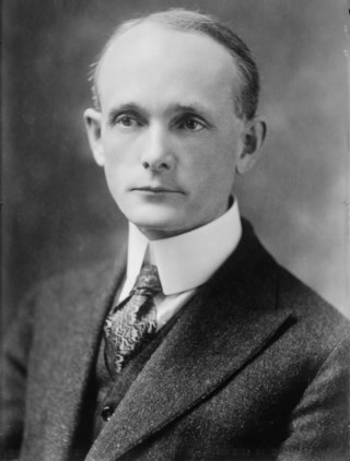
William Phipps Blake was an American geologist, mining consultant, and educator. Among his best known contributions include being the first college trained chemist to work full-time for a United States chemical manufacturer (1850), and serving as a geologist with the Pacific Railroad Survey of the Far West (1853–1856), where he observed and detailed a theory on erosion by wind-blown sand on the geologic formations of southern California, one of his many scientific contributions. He started several western mining enterprises that were premature, including a mining magazine in the 1850s and the first school of mines in the Far West in 1864.
The Utah Geological Survey is based in Salt Lake City, Utah, United States. It also has an office in Cedar City, Utah.
The California Department of Conservation is a department within the government of California, belonging to the California Natural Resources Agency. With a team of scientists, engineers, environmental experts, and other specialists, the Department of Conservation administers a variety of programs vital to California's public safety, environment and economy. The department's mission is to manage California's working lands. It regulates oil, natural gas and geothermal wells; studies and maps earthquakes and other geologic phenomena; maps and classifies areas containing mineral deposits; ensures reclamation of land used for mining; and administers agricultural and open-space land conservation programs. A division within the department dedicated to encouraging beverage container recycling has been moved into the newly created Department of Resources Recovery and Recycling (CalRecycle). Despite the similar name, the Department of Conservation should not be confused with the California Conservation Corps, another department within the Natural Resources Agency, which provides work experience for young adults. The Department of Conservation often collaborates with its federal equivalents, such as the U.S. Geological Survey.
The Kentucky Geological Survey (KGS) is a department of the University of Kentucky that provides information on the geology of Kentucky, but has variously over the course of its history been a state level office, or a sub-division of a state combined geology and forestry department, at times its official State Geologist being prohibited by law from being associated with the University of Kentucky.

The Oregon Department of Geology and Mineral Industries (DOGAMI) is the agency of the government of the U.S. state of Oregon responsible for collecting, maintaining and disseminating geologic information, and regulation of industries which commercially develop the state's geological resources, including Natural gas, Crude oil, and other Mineral exploration and Mining.

In Arizona, copper mining has been a major industry since the 19th century. In 2007, Arizona was the leading copper-producing state in the country, producing 750 thousand metric tons of copper, valued at $5.54 billion. Arizona's copper production was 60% of the total for the United States. Copper mining also produces gold and silver as byproducts. Byproduct molybdenum from copper mining makes Arizona the nation's second-largest producer of that metal. Although copper mineralization was found by the earliest Spanish explorers of Arizona, the territory was remote, and copper could seldom be profitably mined and shipped. Early Spanish, Mexican, and American prospectors searched for gold and silver, and ignored copper. It was not until the completion of the Southern Pacific Railroad in 1876 that copper became broadly economic to mine and ship to market.
The geology of Alabama is marked by abundant geologic resources and a variety of geologic structures from folded mountains in the north to sandy beaches along the Gulf of Mexico coast. Alabama spans three continental geologic provinces as defined by the United States Geological Survey, the Atlantic Plain, Appalachian Highlands, and Interior Plains. The Geological Survey of Alabama breaks these provinces down into more specific physiographic provinces.
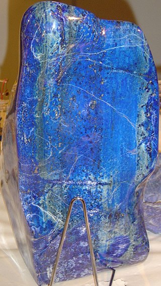
Mining in Afghanistan was controlled by the Ministry of Mines and Petroleum, prior to the August 15th 2021 takeover by the Taliban. It is headquartered in Kabul with regional offices in other parts of the country. Afghanistan has over 1,400 mineral fields, containing barite, chromite, coal, copper, gold, iron ore, lead, natural gas, petroleum, precious and semi-precious stones, salt, sulfur, lithium, talc, and zinc, among many other minerals. Gemstones include high-quality emeralds, lapis lazuli, red garnet and ruby. According to a joint study by The Pentagon and the United States Geological Survey, Afghanistan has an estimated US$1 trillion of untapped minerals.
Israel Charles White was a geologist and professor, internationally known, and the first state geologist of West Virginia.

The Mancos Shale or Mancos Group is a Late Cretaceous geologic formation of the Western United States.
The Department of Mines and Petroleum was a department of the Government of Western Australia until it was superseded by the Department of Mines, Industry Regulation and Safety on 1 July 2017. The department was formed on 1 January 2009, out of the former Department of Industry and Resources and Department of Consumer and Employment Protection, which were split into three new departments, the Department of Mines and Petroleum, the Department of State Development and the Department of Commerce.
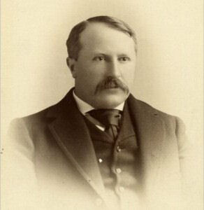
Harry Foster Bain, better known as H. Foster Bain, was an American geologist who served as the 4th Director of the U.S. Bureau of Mines.