Arlit mine

Last updated
Arlit mine
MineArlit1.jpg
Location
Agadez Region
Country Niger
Production
Products uranium

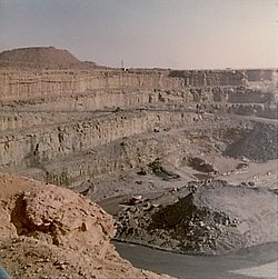
The Arlit mine is a large mine located near Arlit, in the northern part of Niger in Agadez Region. Arlit represents one of the largest uranium reserves in Niger having estimated reserves of 47.5 million tonnes of ore grading 0.014% uranium. [1]

Arlit Place in Agadez Department, Niger

Arlit is an industrial town and capital of the Arlit Department of the Agadez Region of northern-central Niger, built between the Sahara Desert and the eastern edge of the Aïr Mountains. It is 200 km south by road from the border with Algeria. As of 2011, the commune had a total population of 112,432 people.

Niger republic in Western Africa

Niger or the Niger, officially the Republic of the Niger, is a landlocked country in West Africa named after the Niger River. Niger is bordered by Libya to the northeast, Chad to the east, Nigeria to the south, Benin to the southwest, Burkina Faso and Mali to the west, and Algeria to the northwest. Niger covers a land area of almost 1,270,000 km2 (490,000 sq mi), making it the largest country in West Africa. Over 80% of its land area lies in the Sahara Desert. The country's predominantly Islamic population of about 21 million live mostly in clusters in the far south and west of the country. The capital city is Niamey, located in Niger's southwest corner.

Agadez Region Region in Niger

Agadez is an administrative Region in Niger. At 667,799 square kilometres (257,839 sq mi), Agadez is the largest subdivision of an African state. The capital of the department is Agadez.

Related Research Articles

Transport in Niger

Transport in Niger is composed of the transportation systems and methods used in this landlocked nation, with cities separated by huge uninhabited deserts, mountain ranges, and other natural features. A poor nation, Niger's transport system was little developed during the colonial period (1899–1960), relying upon animal transport, human transport, and limited river transport in the far south west and south east. No railways were constructed in the colonial period, and roads outside the capital remained unpaved. The Niger River is unsuitable for large-scale river transport, as it lacks depth for most of the year and is broken by rapids at many spots. Camel caravan transport was historically important in the Sahara desert and Sahel regions which cover most of the north.

Aïr Mountains

The Aïr Mountains or Aïr Massif is a triangular massif, located in northern Niger, within the Sahara Desert. Part of the West Saharan montane xeric woodlands ecoregion, they rise to more than 1,800 m (5,900 ft) and extend over 84,000 km2 (32,000 sq mi). Lying in the midst of desert north of the 17th parallel, the Aïr plateau, with an average altitude between 500 and 900 m, forms an island of Sahel climate which supports a wide variety of life, many pastoral and farming communities, and dramatic geological and archaeological sites. There are notable archaeological excavations in the region that illustrate the prehistoric past of this region. The endangered painted hunting dog once existed in this region, but may now be extirpated due to human population pressures in this region.

Orano Cycle, formerly COGEMA and Areva NC, is a French nuclear company. It is the main subsidiary of Orano S.A. The company was created in 1976 from the production division of the French government's CEA. It is an industrial group active in all stages of the uranium fuel cycle, including uranium mining, conversion, enrichment, spent fuel reprocessing, and recycling. In 2001, COGEMA was merged with Framatome and CEA Industrie to form the larger group Areva; the subsidiary's name was changed to Areva NC in March 2006. In 2018, it changed its name to Orano Cycle to reflect the restructuring of Areva.

In-Gall Place in Agadez Region, Niger

In-Gall is a town in the Agadez Region, Tchirozerine Department of northeast Niger, with a year-round population of less than 500. Known for its oasis and salt flats, In-Gall is the gathering point for the Cure Salee festival of Tuareg and Wodaabe pastoralists to celebrate the end of the rainy season each September. During the festival, InGall's population grows to several thousand nomads, officials, and tourists. As of 2011, the commune had a total population of 47,170 people.

Tuareg rebellion (2007–2009)

The Tuareg Rebellion of 2007–2009 was an insurgency that began in February 2007 amongst elements of the Tuareg people living in the Sahara desert regions of northern Mali and Niger. It is one of a series of insurgencies by formerly nomadic Tuareg populations, which had last appeared in the mid-1990s, and date back at least to 1916. Populations dispersed to Algeria and Libya, as well as to the south of Niger and Mali in the 1990s returned only in the late 1990s. Former fighters were to be integrated into national militaries, but the process has been slow and caused increased resentment. Malian Tuaregs had conducted some raids in 2005–2006, which ended in a renewed peace agreement. Fighting in both nations was carried on largely in parallel, but not in concert. While fighting was mostly confined to guerrilla attacks and army counterattacks, large portions of the desert north of each nation were no-go zones for the military and civilians fled to regional capitals like Kidal Mali and Agadez Niger. Fighting was largely contained within Mali's Kidal Region and Niger's Agadez Region. Algeria helped negotiate an August 2008 Malian peace deal, which was broken by a rebel faction in December, crushed by the Malian military and wholescale defections of rebels to the government. Niger saw heavy fighting and disruption of Uranium production in the mountainous north, before a Libyan backed peace deal, aided by a factional split among the rebels, brought a negotiated ceasefire and amnesty in May 2009.

Arlit Department Department in Agadez Region, Niger

Arlit is a department of the Agadez Region in Niger. Its capital lies at the city of Arlit. As of 2012, the department had a total population of 105,025 people.

Uranium production is an important part of the African economy, with Niger, Namibia, Libya and South Africa creating up to 18% of the world's annual production. Many African countries produce uranium or have untapped uranium ore deposits.

Imouraren Commune and town in Agadez Region, Niger

Imourarene is a town and commune in the Arlit Department of the Agadez Region of northern-central Niger. It is the site of a uranium mining project involving French company Areva and SOPaMin. The U3O8 ore grade at nearby SOMAIR is 14,000 tons at 0.3%, COMINAK is 29,000 t at 0.4% and Imouraren 120,000t at 0.15%.

Oil and mining industry of Niger

The mineral mining industry is a crucial piece of the Economy of Niger. Exports of minerals consistently account for 40% of exports.

Tchirozerine Commune and town in Agadez Region, Niger

Tchirozerine is a town and urban commune in Niger. As of 2011, the commune had a total population of 67,876 people.

SOMAIR mining company of Niger

SOMAIR is a national mining company of Niger in the mining area of its northern zone. Established in 1968, it started uranium mining at the Arlit deposit in 1971, mining 0.30 - 0.35% ore down to depth of 60 metres (200 ft) depth. By 1981, the company was producing 2100 tU/yr and by 2006 it was producing 1565 tU at the Tamou deposit. The production peaked to 3065 tU in 2012. The resources, according to the Red Book, are assessed at 23,170 tU, as of 2010, at 42,200 tU of 0.25%U grade recoverable conventionally, and 5500 tU of 0.07%U grade from heap leaching. SOMAIR is one of two national mining companies in Niger, the other being COMINAK in the nearby Akokan.

COMINAK is a national uranium mining company of Niger.

Akokan, Niger Place in Arlit Department, Niger

Akokan is a mining town in the Arlit Department of the Agadez Region of northern-central Niger. It is located about 5 kilometres (3.1 mi) southwest of Arlit in the Sahara Desert, and roughly 250 kilometres (160 mi) north of Agadez. It is considered to be Niger's "second uranium town". SOMAIR and COMINAK, run by Areva and the Nigerien state, operate uranium mines in the vicinity of the towns of Akokan and Arlit. In the maps of the area, Akokan is classified under "Mine - Agadez-Niger". The Tuareg and Toubou people are local to the area.

The Imouraren mine is a large mine located in the northern part of Niger in Agadez Region. Imouraren represents one of the largest uranium reserves in Niger having estimated reserves of 109.1 million tonnes of ore grading 0.06% uranium.

On 23 May 2013, two coordinated attacks perpetrated by Islamist affiliates targeted the two Niger towns of Agadez and Arlit, the first being a military base the other a French-owned and operated uranium mine. In the first attack on the Niger military base, in which eight attackers participated, 23 soldiers and a civilian were confirmed dead by the next day. The second attack by two suicide bombers also claimed a worker at the mine. The Movement for Oneness and Jihad in West Africa (MUJAO) later claimed responsibility, saying "We attacked France and Niger for its cooperation with France in the war against Sharia ". They also promised more attacks to come in retaliation for Niger's involvement in the Northern Mali conflict. Reports suggested Islamist leader Mokhtar Belmokhtar of being the "mastermind" of both attacks, supervised by his brigade the "Signatories of Blood". These were the first such attacks within the country in Niger's history.

Coal exploitation in Niger is carried out by Société nigérienne du charbon. SONICHAR was created in 1975. It operates an open pit coal mine in Anou Araren in the Agadez Region. It also operates a power plant 2 km away from coal mine.

The geology of Niger comprises very ancient igneous and metamorphic crystalline basement rocks in the west, more than 2.2 billion years old formed in the late Archean and Proterozoic eons of the Precambrian. The Volta Basin, Air Massif and the Iullemeden Basin began to form in the Neoproterozoic and Paleozoic, along with numerous ring complexes, as the region experienced events such as glaciation and the Pan-African orogeny. Today, Niger has extensive mineral resources due to complex mineralization and laterite weathering including uranium, molybdenum, iron, coal, silver, nickel, cobalt and other resources.

RTA (Niger) Place in Agadez Region, Niger

RTA is a village in northern Niger, lying -roughly- halfway between Agadez and Arlit. Administratively, it falls under the Agadez Region, Arlit Department, Dannet Commune.

References

  1. "Uranium in Niger". wise-uranium.org. 2012. Retrieved 2013-07-16.

Coordinates: 18°45′05″N7°18′46″E / 18.7515°N 7.3128°E / 18.7515; 7.3128

Geographic coordinate system Coordinate system

A geographic coordinate system is a coordinate system that enables every location on Earth to be specified by a set of numbers, letters or symbols. The coordinates are often chosen such that one of the numbers represents a vertical position and two or three of the numbers represent a horizontal position; alternatively, a geographic position may be expressed in a combined three-dimensional Cartesian vector. A common choice of coordinates is latitude, longitude and elevation. To specify a location on a plane requires a map projection.