Related Research Articles
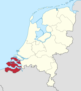
Zeeland is the westernmost and least populous province of the Netherlands. The province, located in the southwest of the country, borders North Brabant to the east, South Holland to the north, as well as the country of Belgium to the south and west. It consists of a number of islands and peninsulas and a strip bordering the Flemish provinces of East and West Flanders. Its capital is Middelburg with a population of 48,544 as of November 2019, although the largest municipality in Zeeland is Terneuzen. Zeeland has two seaports: Vlissingen and Terneuzen. Its area is 2,933 square kilometres (1,132 sq mi), of which 1,154 square kilometres (446 sq mi) is water; it had a population of about 391,000 as of January 2023.

Walcheren is a region and former island in the Dutch province of Zeeland at the mouth of the Scheldt estuary. It lies between the Eastern Scheldt in the north and the Western Scheldt in the south and is roughly the shape of a rhombus. The two sides facing the North Sea consist of dunes and the rest of its coastline is made up of dykes. Middelburg, the provincial capital, lies at Walcheren's centre. Vlissingen, 9 kilometres (5.6 mi) to the south, is the main harbour and the third municipality is Veere.

Middelburg is a city and municipality in the south-western Netherlands serving as the capital of the province of Zeeland. Situated on the central peninsula of the Zeeland province, Midden-Zeeland, it has a population of about 48,000.

Hulst is a municipality and city in southwestern Netherlands in the east of Zeelandic Flanders.

The Western Scheldt in the province of Zeeland in the southwestern Netherlands, is the estuary of the Scheldt river. This river once had several estuaries, but the others are now disconnected from the Scheldt, leaving the Westerschelde as its only direct route to the sea. The Western Scheldt is an important shipping route to the Port of Antwerp, Belgium. Unlike the Eastern Scheldt estuary, it could not be closed off from the sea by a dam as part of the Delta Works. Instead, the dykes around it have been heightened and reinforced.

Zuid-Beveland is part of the province of Zeeland in the Netherlands north of the Western Scheldt and south of the Eastern Scheldt.

The Canal through Walcheren in the Netherlands crosses the east of Walcheren. It connects the Westerschelde and the Veerse Meer.

Arnemuiden is a city of around 5000 people in the municipality of Middelburg in the province of Zeeland in the Netherlands. It is located on the former island of Walcheren, about 3 km east of the city of Middelburg.

Colijnsplaat is a village in the Province of Zeeland, the Netherlands It is a part of the Municipality of Noord-Beveland, and lies about 20 km (12 mi) northeast of Middelburg.

Kleverskerke is a small village in the Dutch province of Zeeland. It is located in the municipality of Middelburg, about 4 kilometres north-east of the city centre.

Nieuw- en Sint Joosland of Nieuwland is a village and a former municipality in the southeast of Walcheren, at the edge of the island, in the municipality Middelburg, in the Dutch province of Zeeland. It has about 1300 inhabitants. Because of its relatively late foundation, Nieuw- en Sint Joosland is not a churchvillage, but more of a wegdorp, despite its clear village centre.
Ritthem is a village in the Dutch province of Zeeland. It is located in the municipality of Vlissingen, about 4 kilometres east of the city.

The County of Zeeland was a county of the Holy Roman Empire in the Low Countries and it later became one of the seven provinces of the Dutch Republic. It covered an area in the Scheldt and Meuse delta roughly corresponding to the modern Dutch province of Zeeland. The County of Zeeland did not include the region of Zeelandic Flanders which was part of Flanders; conversely, the modern Province of Zeeland does not include Sommelsdijk, historically part of the County of Zeeland.
The Sloedam is 1 km long a dam, that was constructed in 1871, as a necessary part of the Roosendaal-Vlissingen Railway, the so-called Zeeuwse Lijn. Additionally this dam connected the island of Walcheren with Zuid-Beveland across the Sloe waterway, and therefore with the mainland of Brabant.

In August 1572, during the course of the Eighty Years' War, the city of Goes, in the Spanish Netherlands, was besieged by Dutch forces with the support of English troops sent by Queen Elizabeth I. This was a menace to the safety of the nearby city of Middelburg, also under siege. Given the impossibility of rescue of Goes by sea, 3,000 soldiers of the Spanish Tercios under the command of Cristóbal de Mondragón waded across the river Scheldt at its mouth, walking 15 miles overnight in water up to chest deep. The surprise arrival of the Tercios forced the withdrawal of the Anglo-Dutch troops from Goes, allowing the Spanish to maintain control of Middelburg, capital of Walcheren Island.

The battle of Zierikzee was a naval battle between a Flemish fleet and an allied Franco-Hollandic fleet which took place on 10 and 11 August 1304. The battle, fought near the town of Zierikzee, ended in a Franco-Dutch victory. The battle is part of a larger conflict between the Count of Flanders and his French feudal lord, King Philip IV of France (1296–1305).
University College Roosevelt (UCR), formerly known as Roosevelt Academy (RA), is a small, honors undergraduate liberal arts and science college located in Middelburg in the Netherlands and the sole university in Zeeland. It offers a residential setting, and is an international honors college of Utrecht University. It is named in honour of the Roosevelt family, which traces its ancestry to the province of Zeeland.
Middelburg Drydock is a former dry dock in Middelburg, Netherlands. The Dock chamber still exists.

The Battle of Veere was a small naval battle that took place in late May 1351 during the Hook and Cod wars.
References
- ↑ "MIDDELBURG". Encyclopedie van Zeeland (in Dutch). 24 November 2020. Retrieved 20 September 2022.
- ↑ "ARNEMUIDEN (stad)". Encyclopedie van Zeeland (in Dutch). 24 November 2020. Retrieved 20 September 2022.