Cinnabar and cinnabarite, likely deriving from the Ancient Greek: κιννάβαρι (kinnabari), refer to the common bright scarlet to brick-red form of mercury(II) sulfide (HgS) that is the most common source ore for refining elemental mercury, and is the historic source for the brilliant red or scarlet pigment termed vermilion and associated red mercury pigments.

Opal is a hydrated amorphous form of silica (SiO2·nH2O); its water content may range from 3 to 21% by weight, but is usually between 6 and 10%. Because of its amorphous character, it is classed as a mineraloid, unlike crystalline forms of silica, which are classed as minerals. It is deposited at a relatively low temperature and may occur in the fissures of almost any kind of rock, being most commonly found with limonite, sandstone, rhyolite, marl, and basalt. Opal is the national gemstone of Australia.

Kenora District is a district and census division in Northwestern Ontario, Canada. It was created in 1907 from parts of Rainy River District. It is geographically the largest division in that province; at 407,213.01 square kilometres (157,225.82 sq mi), it comprises almost 38 percent of the province's land area, making it larger than Newfoundland and Labrador, and slightly smaller than Sweden.

Gold mining is the resource extraction of gold by mining.

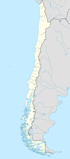
The Tarapacá Region is one of Chile's 16 first-order administrative divisions. It borders the Chilean Arica and Parinacota Region to the north, Bolivia's Oruro Department on the east, the Antofagasta Region on the south and the Pacific Ocean on the west. The port city of Iquique is the region's capital.
A silver rush is the silver-mining equivalent of a gold rush, where the discovery of silver-bearing ore sparks a mass migration of individuals seeking wealth in the new mining region.

The Omineca Mountains, also known as "the Ominecas", are a group of remote mountain ranges in north-central British Columbia, Canada. They are bounded by the Finlay River on the north, the Rocky Mountain Trench on the east, the Nation Lakes on the south, and the upper reaches of the Omineca River on the west. They form a section of the Continental Divide, that, in this region, separates water drainage between the Arctic and Pacific Oceans. The lower course of the Omineca River flows through the heart of the range. To the south of the Ominecas is the Nechako Plateau, to the west the Skeena Mountains and Hazelton Mountains, to the north the Spatsizi Plateau and the Stikine Ranges, while east across the Rocky Mountain Trench are the Muskwa Ranges.

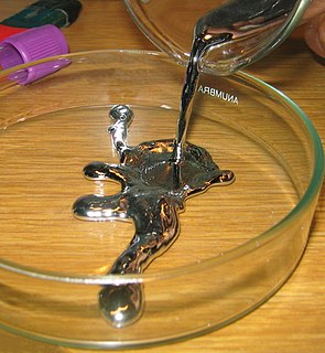
A native metal is any metal that is found pure in its metallic form in nature. Metals that can be found as native deposits singly or in alloys include aluminium, antimony, arsenic, bismuth, cadmium, chromium, cobalt, indium, iron, manganese, molybdenum, nickel, niobium, rhenium, selenium, tantalum, tellurium, tin, titanium, tungsten, vanadium, and zinc, as well as two groups of metals: the gold group, and the platinum group. The gold group consists of gold, copper, lead, aluminium, mercury, and silver. The platinum group consists of platinum, iridium, osmium, palladium, rhodium, and ruthenium. Amongst the alloys found in native state have been brass, bronze, pewter, German silver, osmiridium, electrum, white gold, and silver-mercury and gold-mercury amalgam.

Silver mining is the resource extraction of silver by mining.
The Omineca Gold Rush was a gold rush in British Columbia, Canada in the Omineca region of the Northern Interior of the province. Gold was first discovered there in 1861, but the rush didn't begin until late in 1869 with the discovery at Vital Creek. There were several routes to the goldfields: two were from Fort St. James, one of which was a water route through the Stuart and Tachie Rivers to Trembleur Lake to Takla Lake and the other was overland, called the Baldy Mountain route. A third route came in overland from Hazelton on the Skeena River and a fourth route used the Fraser River and crossed over the Giscome Portage to Summit Lake, through McLeod Lake, and up the Finlay River to the Omineca River.

The Cassiar Country, also referred to simply as the Cassiar, is a historical geographic region of the Canadian province of British Columbia. The Cassiar is located in the northwest portion of British Columbia, just to the northeast of the Stikine Country, while to the south is the Omineca Country. The area is noted for the Cassiar gold rush of the 1870s, when Laketon became its unofficial capital. The ghost town of Cassiar is also located in the Cassiar region.

The Eskay Creek region is a rich gold and silver mining area in the Unuk and Iskut River region on north coastal mountains of British Columbia. Remote and rugged, the area has a service road from the Stewart-Cassiar Highway at Bell 2 Services.
The Germansen River, formerly Germansen Creek, is a major south tributary of the Omenica River in the Northern Interior of British Columbia, Canada. The settlement and former gold-rush centre of Germansens Landing is located at its confluence with the Omineca. Along its course is Germansen Lake at 55°41′45″N124°51′10″W, south of which is the Germansen Range and Mount Germansen.
Coccinite is a rare mercury iodide mineral with chemical formula of HgI2, mercury(II) iodide. in addition to its discovery locality of Casas Viejas, Mexico, it has also been reported from Broken Hill, New South Wales, and from a uranium mine in Thuringia and old mercury workings in the Rhineland-Palatinate in Germany. At the Thuringia deposit the mineral occurs as a sublimation product resulting from fires associated with pyrite bearing, graptolitic slate.

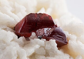
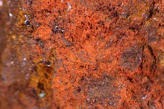
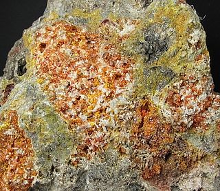
Walfordite is a very rare tellurite mineral that was discovered in Chile in 1999. The mineral is described as orange with orange-yellow streak, and is determined to have a chemical formula of Fe3+,Te6+Te4+3O8 with minor titanium and magnesium substitution resulting in an approximate empirical formula of (Fe3+,Te6+,Ti4+,Mg)(Te4+)3O8.
Vital Creek is a creek located in the Omineca Country region of British Columbia, flowing eastward from its source in the Vital Range to meet Silver Creek, joining that creek from the west about 5 miles from its mouth into the Omineca River, about 41 km northeast of Takla Landing.
Arqueros is a mining district in the Chilean Norte Chico region. It is located 7 km northwest of the Talcuna copper district. The discovery of silver at Arqueros in the 1830s led the Norte Chico mountains north of La Serena to be exhaustively prospected sparkling the Chilean silver rush in the 1830s and 1840s.
Hemihedrite is a rare lead zinc chromate silicate mineral with formula Pb10Zn(CrO4)6(SiO4)2(F,OH)2. It forms a series with the copper analogue iranite.

The Mineral Park mine is a large open pit copper mine located in the Cerbat Mountains 14 miles northwest of Kingman, Arizona, in the southwestern United States. A 2013 report said that Mineral Park represented one of the largest copper reserves in the United States and in the world, having estimated reserves of 389 million tonnes of ore grading 0.14% copper and 31 million oz of silver.