Māori, or te reo Māori, commonly shortened to te reo, is an Eastern Polynesian language spoken by the Māori people, the indigenous population of mainland New Zealand. A part of the Austronesian language family, it is closely related to Cook Islands Māori, Tuamotuan, and Tahitian. The Maori Language Act 1987 gave the language recognition as one of New Zealand's official languages.
Aotearoa is the contemporary Māori-language name for New Zealand. The name was originally used by Māori in reference to only the North Island, the name of the whole country being Aotearoa me Te Waipounamu. In the pre-European era, Māori did not have one name for the country as a whole.

The North Island, also officially named Te Ika-a-Māui, is one of the two main islands of New Zealand, separated from the larger but less populous South Island by Cook Strait. With an area of 113,729 km2 (43,911 sq mi), it is the world's 14th-largest island. It has a population of 3,922,000, which is 77% of New Zealand's residents, making it the most populous island in Polynesia and the 28th-most-populous island in the world.

The South Island, also officially named Te Waipounamu, is the larger of the two major islands of New Zealand in surface area, the other being the smaller but more populous North Island. It is bordered to the north by Cook Strait, to the west by the Tasman Sea, and to the south and east by the Pacific Ocean. The South Island covers 150,437 square kilometres (58,084 sq mi), making it the world's 12th-largest island. At low altitude, it has an oceanic climate.

The Chatham Islands are an archipelago in the Pacific Ocean about 800 km (430 nmi) east of New Zealand's South Island. They are administered as part of New Zealand. The archipelago consists of about 10 islands within an approximate 60 km (30 nmi) radius, the largest of which are Chatham Island and Pitt Island (Rangiauria). They include New Zealand's easternmost point, the Forty-Fours. Some of the islands, formerly cleared for farming, are now preserved as nature reserves to conserve some of the unique flora and fauna.

The Northland Region is the northernmost of New Zealand's 16 local government regions. New Zealanders sometimes refer to it as the Winterless North because of its mild climate all throughout the year. The main population centre is the city of Whangārei, and the largest town is Kerikeri. At the 2018 New Zealand census, Northland recorded a population growth spurt of 18.1% since the previous 2013 census, placing it as the fastest growing region in New Zealand, ahead of other strong growth regions such as the Bay of Plenty Region and Waikato.

Ngāpuhi is a Māori iwi associated with the Northland regions of New Zealand centred in the Hokianga, the Bay of Islands, and Whangārei.
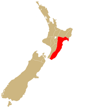
Ngāti Kahungunu is a Māori iwi located along the eastern coast of the North Island of New Zealand. The iwi is traditionally centred in the Hawke's Bay and Wairārapa regions. The Kahungungu iwi also comprises 86 hapū (sub-tribes) and 90 mārae.
Ngāti Toa, Ngāti Toarangatira or Ngāti Toa Rangatira, is a Māori iwi (tribe) based in the southern North Island and in the northern South Island of New Zealand. Its rohe extends from Whanganui in the north, Palmerston North in the east, and Kaikōura and Hokitika in the south. Ngāti Toa remains a small iwi with a population of only about 9000. It has four marae: Takapūwāhia and Hongoeka in Porirua City, and Whakatū and Wairau in the north of the South Island. Ngāti Toa's governing body has the name Te Rūnanga o Toa Rangatira.
Cook Islands Māori is an Eastern Polynesian language that is the official language of the Cook Islands. Cook Islands Māori is closely related to New Zealand Māori, but is a distinct language in its own right. Cook Islands Māori is simply called Māori when there is no need to disambiguate it from New Zealand Māori, but it is also known as Māori Kūki ʻĀirani or, controversially, Rarotongan. Many Cook Islanders also call it Te reo Ipukarea, literally "the language of the Ancestral Homeland".
Tākitimu was a waka (canoe) with whakapapa throughout the Pacific particularly with Samoa, the Cook Islands, and New Zealand in ancient times. In several Māori traditions, the Tākitimu was one of the great Māori migration ships that brought Polynesian migrants to New Zealand from Hawaiki. The canoe was said to be captained by Tamatea.

New Zealand is an island country in the southwestern Pacific Ocean. It consists of two main landmasses—the North Island and the South Island —and over 700 smaller islands. It is the sixth-largest island country by area and lies east of Australia across the Tasman Sea and south of the islands of New Caledonia, Fiji, and Tonga. The country's varied topography and sharp mountain peaks, including the Southern Alps, owe much to tectonic uplift and volcanic eruptions. New Zealand's capital city is Wellington, and its most populous city is Auckland.
Sealing continues at Bass Strait and the Antipodes Islands. At the end of the year there is a new sealing rush to the Bounty and Auckland Islands. Few sealers, if any, are known to have visited the Foveaux Strait area at this time, although this may be due in part to the secrecy of the captains and owners in reporting where they operate and/or the existence of the Strait not yet being widely known. Whaling continues off the east coast of the North Island. Ships are now visiting the Bay of Islands on a reasonably regular basis. The first reports about the poor behaviour of ships crews are sent to the Church Missionary Society in London.
Sealing continues at Bass Strait but declines at Dusky Sound which is still used for provisioning. There is a new rush to the Antipodes Islands. The existence of Foveaux Strait is not reported in Port Jackson until early the following year so sealers are still travelling via the south of Stewart Island/Rakiura which some also visit. At Stewart Island/Rakiura, and its smaller surrounding islands, the sealers often encounter Māori which they have not done at all at Dusky Sound. As many as 16 whalers are operating around the north of New Zealand, occasionally visiting the Bay of Islands and taking an increasing number of Māori on board as crew.
The New Zealand Geographic Board Ngā Pou Taunaha o Aotearoa (NZGB) was established by the New Zealand Geographic Board Act 1946, which has since been replaced by the New Zealand Geographic Board Act 2008. Although an independent institution, it is responsible to the Minister for Land Information.

Stewart Island is New Zealand's third-largest island, located 30 kilometres south of the South Island, across the Foveaux Strait. It is a roughly triangular island with a total land area of 1,746 km2 (674 sq mi). Its 164-kilometre (102 mi) coastline is deeply creased by Paterson Inlet (east), Port Pegasus (south), and Mason Bay (west). The island is generally hilly and densely forested. Flightless birds, including penguins, thrive because there are few introduced predators. Almost all the island is owned by the New Zealand government, and over 80 per cent of the island is set aside as the Rakiura National Park.

Māori are the indigenous Polynesian people of mainland New Zealand. Māori originated with settlers from East Polynesia, who arrived in New Zealand in several waves of canoe voyages between roughly 1320 and 1350. Over several centuries in isolation, these settlers developed their own distinctive culture, whose language, mythology, crafts, and performing arts evolved independently from those of other eastern Polynesian cultures. Some early Māori moved to the Chatham Islands, where their descendants became New Zealand's other indigenous Polynesian ethnic group, the Moriori.

The Bay of Plenty is a large bight along the northern coast of New Zealand's North Island. It stretches 260 kilometres (160 mi) from the Coromandel Peninsula in the west to Cape Runaway in the east. Called Te Moana-a-Toi in the Māori language after Toi, an early ancestor, the name 'Bay of Plenty' was bestowed by James Cook in 1769 when he noticed the abundant food supplies at several Māori villages there, in stark contrast to observations he had made earlier in Poverty Bay.

Ulva Island-Te Wharawhara Marine Reserve is a marine reserve covering an area of 1,075 hectares south-west and north-east of Ulva Island, in the Paterson Inlet of New Zealand's Stewart Island. It was established in 2004 and is administered by the Department of Conservation.
