
The New Jersey Turnpike (NJTP) is a system of controlled-access toll roads in the U.S. state of New Jersey. The turnpike is maintained by the New Jersey Turnpike Authority. The 117.2-mile (188.6 km) mainline's southern terminus is at the Delaware Memorial Bridge on I-295 in Pennsville. Its northern terminus is at an interchange with US 46 in Ridgefield Park. Construction of the mainline, from concept to completion, took a total of 22 months between 1950 and 1951. It was opened to traffic on November 5, 1951, between its southern terminus and exit 10.

The Pennsylvania Turnpike, sometimes shortened to Penna Turnpike or PA Turnpike, is a controlled-access toll road which is operated by the Pennsylvania Turnpike Commission (PTC) in Pennsylvania. It runs for 360 miles (580 km) across the southern part of the state, connecting Pittsburgh and Philadelphia, and passes through four tunnels as it crosses the Appalachian Mountains. A component of the Interstate Highway System, it is part of Interstate 76 (I-76) between the Ohio state line and Valley Forge. I-70 runs concurrently with I-76 between New Stanton and Breezewood, Interstate 276 (I-276) between Valley Forge and Bristol Township, and I-95 from Bristol Township to the New Jersey state line.

Elk County is a county in the Commonwealth of Pennsylvania. As of the 2020 United States census, the population was 30,990. Its county seat is Ridgway. The county was created on April 18, 1843, from parts of Jefferson, Clearfield, and McKean Counties. Elk County is named for the now-extinct eastern elk that historically inhabited the region. The county is part of the North Central Pennsylvania region of the state.

Horton Township is a township in Elk County, Pennsylvania, United States. The population was 1,365 at the 2020 census, down from 1,452 in 2010.
Millstone Township is a township in Elk County, Pennsylvania, United States. The population was 95 at the 2020 census, up from 82 in 2010.

Ridgway is a borough in and the county seat of Elk County, Pennsylvania. As of the 2020 census it had a population of 4,039

Spring Creek Township is a township in Elk County, Pennsylvania, United States. The population was 198 at the 2020 census, down from 233 in 2010.

Heath Township is a township in Jefferson County, Pennsylvania, United States. The population was 117 at the 2020 census, down from the figure of 124 tabulated in 2010. It was named for early Jefferson County settler Elijah Heath. Heath Township is the second-smallest municipality in Jefferson County.
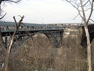
The Whirlpool Rapids Bridge, commonly known as the Whirlpool Bridge or the Lower Steel Arch Bridge, is a spandrel braced, riveted, two-hinged arch bridge that crosses the Canada–United States border, connecting the commercial downtown districts of Niagara Falls, Ontario, and Niagara Falls, New York. This bridge is located approximately 1.5 kilometres (0.9 mi) north of the Rainbow Bridge and about 2 kilometres (1.2 mi) from the Falls. It was acquired by the Niagara Falls Bridge Commission in January 1959. Immediately upstream is the similar arch-style Michigan Central Railway Bridge, which has been out of service since 2001.
The New York State Thruway is a system of controlled-access toll roads spanning 569.83 miles (917.05 km) within the U.S. state of New York. It is operated by the New York State Thruway Authority (NYSTA), a New York State public-benefit corporation. The 496.00-mile (798.23 km) mainline is a freeway that extends from the New York City line at Yonkers to the Pennsylvania state line at Ripley by way of I-87 and I-90 through Albany, Syracuse, and Buffalo. According to the International Bridge, Tunnel and Turnpike Association, the Thruway is the fifth-busiest toll road in the United States. The toll road is also a major route for long distance travelers linking the cities of Toronto, Buffalo, and Montreal with Boston and New York City.

The Calhoun Street Toll Supported Bridge is a historic bridge connecting Calhoun Street in Trenton, New Jersey across the Delaware River to East Trenton Avenue in Morrisville, Bucks County, Pennsylvania, United States. It was constructed by the Phoenix Bridge Company of Phoenixville, Pennsylvania, in 1884, replacing an earlier bridge built in 1861. The bridge was part of the Lincoln Highway until 1920, and was later connected to Brunswick Circle by the Calhoun Street Extension as part of a bypass of downtown Trenton. Before 1940, trolleys of the Trenton-Princeton Traction Company, utilized this bridge to cross into Pennsylvania. The bridge is owned by the Delaware River Joint Toll Bridge Commission, and is maintained with tolls from other bridges. It carries Light vehicle traffic, and streetcars until 1940.

The Milford–Montague Toll Bridge is a truss bridge that crosses the Delaware River, connecting Montague Township, New Jersey to Dingman Township, Pennsylvania on U.S. Route 206, near the town of Milford. The two-lane bridge, which opened on December 30, 1953, has a total length of 1,150 feet, and is operated by the Delaware River Joint Toll Bridge Commission.

The Delaware River–Turnpike Toll Bridge is a four-lane, steel through arch bridge crossing the Delaware River between Burlington Township, Burlington County, New Jersey and Bristol Township, Bucks County, Pennsylvania, United States. As a part of Interstate 95 (I-95), it is a major highway link between Philadelphia and New York City. The bridge also connects the Pennsylvania Turnpike's east-west mainline with the main trunk of the New Jersey Turnpike, via the Pearl Harbor Memorial Turnpike Extension. Tolls are collected only in the west/southbound direction via electronic toll collection.

Pennsylvania Route 66 (PA 66) is a 139.7-mile-long (224.8 km) state highway in Western Pennsylvania. Its southern terminus is at U.S. Route 119 near Interstate 70 (I-70) near New Stanton. Its northern terminus is at US 6 in Kane.
Little Toby Creek is a tributary of the Clarion River in northwest Pennsylvania in the United States.

Washington Crossing Bridge is a truss bridge spanning the Delaware River that connects Washington Crossing, Hopewell Township in Mercer County, New Jersey with Washington Crossing, Upper Makefield Township in Bucks County, Pennsylvania. It was built in 1904 by the Taylorsville Delaware Bridge Company. It serves as the connector of Pennsylvania Route 532 on the Pennsylvania side, with County Route 546 on the New Jersey side. The bridge is currently owned and operated by the Delaware River Joint Toll Bridge Commission.
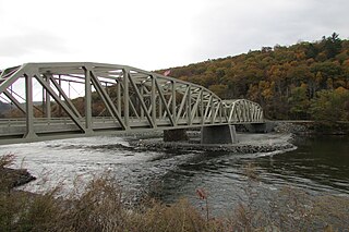
The Pond Eddy Bridge is a truss bridge spanning the Delaware River between the hamlet of Pond Eddy in Lumberland, New York and the settlement informally called Pond Eddy in Shohola Township, Pennsylvania; it is the Pennsylvania community's only road connection. It is accessible from NY 97 in Lumberland on the New York side and two dead-end local roads, Flagstone Road and Rosa Road on the Pennsylvania side. The current bridge was built in 2018, replacing one from 1903.

The Skinners Falls–Milanville Bridge is a closed bridge spanning the Delaware River between Milanville, Damascus Township, Pennsylvania and the hamlet of Skinners Falls in Cochecton, New York. The 466.5-foot (142.2 m) long Baltimore truss bridge carried traffic of Calkins Road in Milanville and Skinners Falls Road in Cochecton over a single wooden lane of traffic until its final closure in October 2019. The bridge is one of two bridges on the National Register of Historic Places along the river in Sullivan County, and is a contributing member of the Milanville Historic District.
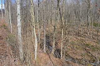
The Pennsylvania State Game Lands Number 25 are Pennsylvania State Game Lands in Elk County in Pennsylvania in the United States providing hunting, bird watching, and other activities.
The Pennsylvania State Game Lands Number 28 are Pennsylvania State Game Lands in Elk, Forest and Jefferson Counties in Pennsylvania in the United States providing hunting, bird watching, and other activities.


