
George Street is the main street of Dunedin, the second largest city in the South Island of New Zealand. It runs for two and a half kilometres north-northeast from The Octagon in the city centre to the foot of Pine Hill. It is straight and undulates gently as it skirts the edge of the hills to its northwest. South of The Octagon, Princes Street continues the line of George Street south-southwest for two kilometres.

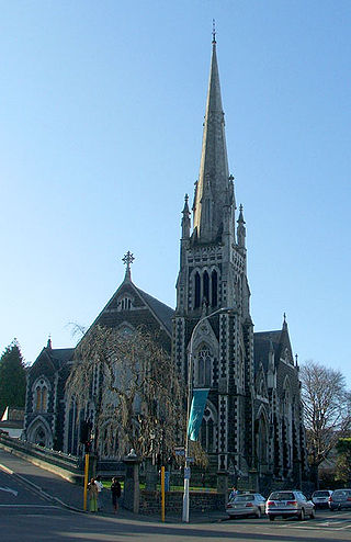
First Church is a prominent church in the New Zealand city of Dunedin. It is located in the heart of the city on Moray Place, 100 metres to the south of the city centre. The church is the city's primary Presbyterian church. The building is regarded as the most impressive of New Zealand's nineteenth-century churches, and is listed by Heritage New Zealand as a Category I structure.

Princes Street is a major street in Dunedin, the second largest city in the South Island of New Zealand. It runs south-southwest for two kilometres from The Octagon in the city centre to the Oval sports ground, close to the city's Southern Cemetery. North of The Octagon, George Street continues the line of Princes Street north-northeast for two and a half kilometres. Princes Street is straight but undulating, skirting the edge of the City Rise to its northwest. The part of the street immediately below The Octagon is the steepest section, as the road traverses an old cutting through Bell Hill.

Moray Place is an octagonal street which surrounds the city centre of Dunedin, Otago, New Zealand. The street is intersected by Stuart Street, Princes Street and George Street. Like many streets in Dunedin, it is named for a street in the Scottish capital Edinburgh.

Logan Park is a sporting venue in the city of Dunedin, New Zealand. It lies on land reclaimed from the former Lake Logan.

The villages and then city that lay at the head of Otago Harbour never existed in isolation, but have always been a staging ground between inland Otago and the wider world. While Dunedin's current official city limits extend north to Waikouaiti, inland to Middlemarch and south to the Taieri River mouth, this articles focus is the history of the Dunedin urban area, only mentioning Mosgiel, the Otago Peninsula, Port Chalmers and inland Otago for context.

Thomas Burns was a prominent Scottish early European settler and religious leader of the province of Otago in New Zealand.
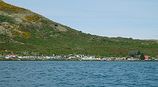
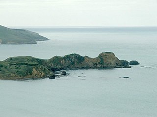
The settlement of Harington Point lies within the boundaries of the city of Dunedin, New Zealand. It is located at the Otago Heads, at the northeastern end of Otago Peninsula, close to the entrance of Otago Harbour. The mouth of the harbour is at its narrowest at Harington Point, only some 400 metres separating the point from the mudflats at Aramoana on the opposing coast.

Caversham is one of the older suburbs (neighbourhoods) of the city of Dunedin, in New Zealand's South Island. It is sited at the western edge of the city's central plain at the mouth of the steep Caversham Valley, which rises to the saddle of Lookout Point. Major road and rail routes south lie nearby; the South Island Main Trunk railway runs through the suburb, and a bypass skirts its main retail area, connecting Dunedin's one-way street system with the Dunedin Southern Motorway. The suburb is linked by several bus routes to its neighbouring suburbs and central Dunedin.
Knox Church is a notable building in Dunedin, New Zealand. It houses the city's second Presbyterian congregation and is the city's largest church of any denomination.

Kensington is a small suburb of the New Zealand city of Dunedin, nestled to the south of a hilly spur between the central city and the major suburb of South Dunedin, some 2.4 kilometres (1.5 mi) to the south of the city centre. The suburb was named for the leafy London suburb, possibly by John Hyde Harris, who subdivided the area in the 1860s.
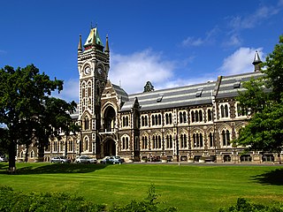
The University of Otago Clocktower complex is a group of architecturally and historically significant buildings in the centre of the University of Otago campus. Founded in Dunedin, New Zealand, in 1869, the University of Otago was the expression of the province's Scottish founders' commitment to higher education. They were also the inheritors of a strong architectural tradition and gritty determination. Defending the decision to build in expensive materials in an elaborate historicizing manner, the chancellor, Donald Stuart, said "the Council had some old-world notions and liked to have a university with some architectural style". This attitude persisted for over 50 years and resulted in an impressive group of buildings.
The Southern Cemetery in the New Zealand city of Dunedin was the first major cemetery to be opened in the city. The cemetery was opened in 1858, ten years after the founding of the city in an area known as Little Paisley. This area lies at the southern end of Princes Street, one of the city's main streets, close to the suburbs of Kensington, Maryhill, and The Glen.

The Town Belt is a green belt which surrounds the centre of the New Zealand city of Dunedin. Covering a total of over 200 hectares, it extends around three sides of the city's centre at a distance from it of some 1–3 km (1-2 mi) in a broad 7 km (4 mi) crescent from the Oval at Kensington in the south through the suburbs of Mornington, City Rise, Belleknowes, Roslyn, Maori Hill, Prospect Park, Glenleith, Woodhaugh, The Gardens and Dunedin North and the slopes of Signal Hill. The fourth side of the central city is bounded by the Otago Harbour.

The Exchange is an area of central Dunedin, in the South Island of New Zealand.
Huriawa, commonly known as Huriawa Peninsula or Karitane Peninsula, is a headland on the coast of Otago, New Zealand. It is located 35 kilometres north of Dunedin city centre, immediately to the southeast of the settlement of Karitane.

The Otago Heads is the historic name given to the headlands and coastal settlements close to the mouth of the long drowned volcanic rift which forms the Otago Harbour, in the South Island of New Zealand.

The Warehouse Precinct is an urban area of the New Zealand city of Dunedin. Sited on reclaimed land at the northernmost tip of the Southern Endowment, it lies between 1 and 2 kilometres south of The Octagon, the city's centre.

Queens Gardens is a roughly triangular area of trees and lawn in central Dunedin, New Zealand.

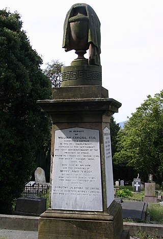
The Cargill Monument is a notable public monument in central Dunedin, New Zealand. It is dedicated to the city's founding father, Captain William Cargill, and is approximately 7.5 metres (25 ft) in height.
