Related Research Articles

South Canara was a district of the Madras Presidency of British India, located at 13.00°N 75.40°E. It covered the areas of the present-day districts of Dakshina Kannada and Udupi of Karnataka and the Kasaragod District of Kerala. The district was one of the most heterogeneous of Madras Presidency with Tulu, Kannada, Konkani, Malayalam, Urdu and Beary being the principal languages spoken. It was succeeded by Dakshina Kannada in 1947.

Bagalkot district, is an administrative district in the Indian state of Karnataka. The district headquarters is located in the town of Bagalkot. The district is located in northern Karnataka and borders Belgaum, Gadag, Koppal, Raichur and Bijapur. The new Bagalkot district was carved out of Bijapur in 1997 via Government of Karnataka directive Notification RD 42 LRD 87 Part III. The bifurcated Bagalkot district consists of nine taluks — Badami, Bagalkot, Bilagi, Guledgudda, Rabkavi Banhatti, Hunagund, Ilkal, Jamakhandi and Mudhol.
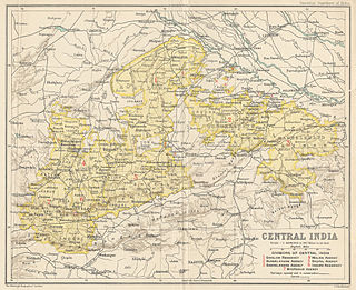
Bhopawar Agency was a sub-agency of the Central India Agency in British India with the headquarters at the town of Bhopawar, so the name. Bhopawar Agency was created in 1882 from a number of princely states in the Western Nimar and Southern Malwa regions of Central India belonging to the former Bhil Agency and Bhil Sub-agency with the capitals at Bhopawar and Manpur. The agency was named after Bhopawar, a village in Sardarpur tehsil, Dhar District of present-day Madhya Pradesh state. Manpur remained a strictly British territory.

Hassan is one of the 30 districts of Karnataka state, India. The district headquarter is Hassan. It is located between Bangalore and Mangalore.

Tiruchirappalli District is one of the 38 districts, [located along the Kaveri River ] in Tamil Nadu, India. The main town in Tiruchirappalli District is the city of Tiruchirappalli, also known as Trichy. During the British Raj, Tiruchirappalli was known as Trichinopoly, and was a district of the Madras Presidency; it was renamed upon India's declaration of independence in 1947. As of 2011, the district had a population of 2,722,290 with 1,013 females for every 1,000 males.
Alampur is a town situated in Jogulamba Gadwal district, in the Indian state of Telangana. Alampur is the meeting point of the sacred rivers Tungabhadra and Krishna and is referred to as Dakshina Kashi and the Western Gateway of Srisailam, the famous Shaivite pilgrim centre. The Sacredness of Alampur Temple is mentioned in the Skanda Purana. The principal deities at Alampur are Brahmeswara and Jogulamba. It is surrounded by the Nallamala hills. Alampur is situated on the left bank of the Tungabhadra river. According to The Imperial Gazetteer of India, Alampur was a taluk of Raichur district, Hyderabad State. It has an area of 184 square miles (480 km2) in 43 villages.

Hoskote is a taluk in Bangalore Rural District, India. Headquartered at the Hosakote town, it consists of five hoblis - Anugondanahalli, Jadigenahalli, Kasaba, Nandagudi and Sulibele.

Palakonda is a town in Srikakulam district of the Indian state of Andhra Pradesh. It is a nagar panchayat and the mandal headquarters of Palakonda mandal in Palakonda revenue division

Kalwakurthy is a town and revenue division in Nagarkurnool district of Telangana, India. It is second largest town in nagarkurnool district after nagarkurnool by area. It is located 80 km from Hyderabad on Srisailam highway as well as Kodada to Jadcherla highway. It is around 31.7 km from the district headquarters of Nagarkurnool.
The Trichinopoly district was a district of the erstwhile Madras Presidency of British India. It covered the present-day districts of Tiruchirappalli, Karur, Ariyalur and Perambalur in the Indian state of Tamil Nadu. The administrative headquarters was the town of Trichinopoly, Trichy or Tiruchi, now known as Tiruchirappalli. The district covered an area of 2,632 square miles (6,820 km2) in 1907. It was bound by the districts of South Arcot to the north, Salem to the west, Coimbatore to the west and north-west, Tanjore to the east and Madurai to the south. The princely state of Pudukkottai remained within the jurisdiction of Trichinopoly district from 1865 to 1947.

Tanjore District was one of the districts in the erstwhile Madras Presidency of British India. It covered the area of the present-day districts of Thanjavur, Tiruvarur,Nagapattinam, Mayiladuthurai and Aranthangi taluk of Pudukkottai District in Tamil Nadu. Apart from being a bedrock of Hindu orthodoxy, Tanjore was a centre of Chola cultural heritage and one of the richest and most prosperous districts in Madras Presidency.

South Arcot District was a district in the Madras Presidency of British India. It covered the area of the present-day districts of Cuddalore, Kallakurichi and Viluppuram in the Indian state of Tamil Nadu. The district was divided into eight taluks and covered a total area of 13,510 square kilometres (5,217 sq mi). The administrative headquarters was the town of Cuddalore.
Chingleput district was a district in the Madras Presidency of British India. It covered the area of the present-day districts of Kanchipuram, Chengalpattu and Tiruvallur and parts of Chennai city. It was sub-divided into six taluks with a total area of 7,970 square kilometres (3,079 sq mi). The first capital was the town of Karunguzhi, with an interruption between 1825 and 1835, administrative headquarters were transferred to Kanchipuram. In 1859 the capital Saidapet, now a neighbourhood in the city of Chennai, was made the administrative headquarters of the district.

Sangli State was one of the 11-gun salute Maratha princely states of British India. It was under the Kolhapur-Dekkan Residency in the Bombay Presidency, and later the Deccan States Agency.
Amrabad is a Mandal in Nagarkurnool district, Telangana It is the largest mandal in the district area-wise, but population density is less. Large portions of the mandal is occupied by Nallamala forests. Amrabad also served as the headquarters of the taluka before separate mandals were formed. It is inhabited by tribal population, mostly Chenchus.
Makthal is a Mandal in Narayanpet district, Telangana. It is also an assembly constituency in the Telangana Legislative Assembly.
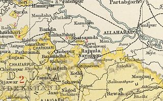
Taraon, also spelt 'Tarahwan' and 'Tarahuhān', was a jagir in India during the British Raj. It had an area of 67 square miles and its population was distributed in 13 villages. The capital of the state was in Pathraundi, located about 1.5 km from Karwi railway station of the Great Indian Peninsula Railway.
Pahra was a jagir in India during the British Raj. It was under the Bundelkhand Agency of the Central India Agency until 1896 when it was transferred to the Baghelkhand Agency. It was later transferred back to the Bundelkhand Agency.

Kang Jagir is a medium size village in Phillaur tehsil of Jalandhar District of Punjab State, India. The village is administrated by Sarpanch who is elected representative of the village. It is 2.4 kilometres away from Jajja Khurd and 5.5 kilometres away from a main market place in the census town Apra. Kang Jagir has its closest postal head office 5.1 kilometres away in Bara Pind. The village is 50 kilometres east of Jalandhar, 11.7 kilometres from Phillaur and 124 kilometres away from the state capital Chandigarh.
Multhan is a village in a dhar district Madhya pardesh and average population of this village is 7500.