
Ash Creek is a stream in northern Washington County, Utah, United States. [1] It is a tributary of the Virgin River. Ash Creek was named after the ash timber near its course. [2]
Ash Creek is a stream in northern Washington County, Utah, United States. [1] It is a tributary of the Virgin River. Ash Creek was named after the ash timber near its course. [2]

The Escalante River is a tributary of the Colorado River. It is formed by the confluence of Upper Valley and Birch Creeks near the town of Escalante in south-central Utah, and from there flows southeast for approximately 90 mi (140 km) before joining Lake Powell. Its watershed includes the high forested slopes of the Aquarius Plateau, the east slope of the Kaiparowits Plateau, and the high desert north of Lake Powell. It was the last river of its size to be discovered in the 48 contiguous U.S. states. The average discharge is approximately 146 cfs.
Buckskin Gulch is a gulch and canyon located in southern Kane County, Utah, near the Arizona border in the Paria Canyon-Vermilion Cliffs Wilderness. With a length of over 16 miles (26 km), it is one of the main tributaries of the Paria River, a tributary of the Colorado River.

The Price River is a 137-mile-long (220 km) southeastward flowing river in Carbon, Utah and Emery counties in eastern Utah. It is a tributary to the Green River, itself a tributary to the Colorado River.
Stony Creek is a 23.0-mile-long (37.0 km) tributary of the Susquehanna River in Dauphin County, Pennsylvania, in the United States.
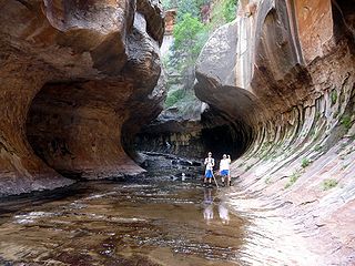
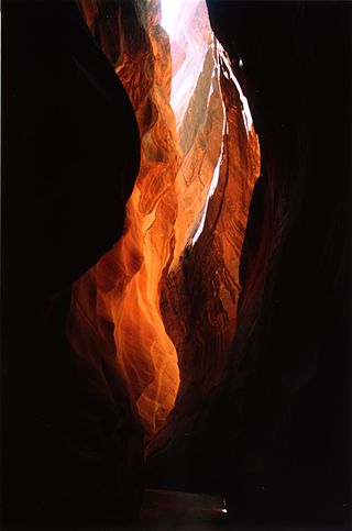
The Subway is a small, uniquely-shaped slot canyon within the Zion Wilderness in Zion National Park in northeastern Washington County, Utah, United States. The National Park Service limits access to the canyon via a permit system.

Kanab Creek is one of the many tributaries of the Colorado River. It begins in Kane County, Utah, just south of the watershed to the Great Basin and flows 125 miles (201 km) south to the Colorado River.
The Beaver Dam Wash is a seasonal stream near the southwestern Utah-Nevada border in the United States. At its southern end in northern Arizona, near the point where it empties into the Virgin River, the stream flows throughout the year. Part of the wash is in the Beaver Dam Wash National Conservation Area, managed by the Bureau of Land Management. The wash was so named on account of beaver dams which once were built on its course.

The Canyons of the Escalante is a collective name for the erosional landforms created by the Escalante River and its tributaries—the Escalante River Basin. Located in southern Utah in the western United States, these sandstone features include high vertical canyon walls, numerous slot canyons, waterpockets, domes, hoodoos, natural arches and bridges. This area—extending over 1,500 square miles (3,885 km2) and rising in elevation from 3,600 ft (1,097 m) to over 11,000 ft (3,353 m)—is one of the three main sections of the Grand Staircase–Escalante National Monument, and also a part of the Glen Canyon National Recreation Area, with Capitol Reef National Park being adjacent to the east.

Ash Creek is a short stream in Polk County, in the U.S. state of Oregon. Formed by the merger of its north and middle forks near Monmouth, it flows generally east to meet the Willamette River at Independence. The creek passes under Oregon Route 51 just before entering the river. The creek's mouth is about 95 miles (153 km) upstream of the Willamette's confluence with the Columbia River.
Montezuma Creek is a tributary of the San Juan River. The stream is approximately 73 miles (117 km) long and is a seasonal river, becoming dry for several months of the year.
Sheep Creek is a geographical place name. With variations, the name is given to hundreds of bodies of water, roads, canals, reservoirs and populated areas in the United States and other countries. It is the name of a tributary to Lockyear Creek in Queensland, Australia, and the name of at least three bodies of water in Canada. The U.S. state of Montana has 85 different locales that bear that name or a derivation. The U.S. state of Idaho has 92 natural and man-made areas that incorporate Sheep Creek into their names. Nature areas that include trails named Sheep Creek can be found in Canada's Yukon Territory, Colorado's Larimer County and in Utah's Bryce Canyon National Park.
Recapture Canyon is a canyon along Recapture Creek east of Blanding, San Juan County, Utah, United States. It is an archaeological site, and is located on federal land. The Bureau of Land Management closed it to motorized vehicles in 2007 due to damage caused by illegal trail construction.
Northrop, now a ghost town, was a small, early settlement in Washington County, Utah, United States, established in 1861 by Isaac Behunin. It was located at the confluence of the North Fork and East Fork of the Virgin River. It was one of the settlements formed as part of the cotton growing colony in the County.

Laguña Creek also formerly also known as Tyende Creek, is a stream in the Navajo and Apache Counties of Arizona. Laguña Creek has its source at 36°41′15″N110°30′36″W, at the confluence of Long Canyon and Dowozhiebito Canyon at an elevation of 6,325 feet at the head of Tsegi Canyon. Its mouth is in the Chinle Valley at its confluence with Chinle Wash which together forms Chinle Creek, at an elevation of 4,774 feet. Chinle Creek is a tributary of San Juan River which is in turn a tributary of the Colorado River.

Chinle Creek is a tributary stream of the San Juan River in Apache County, Arizona and San Juan County, Utah. Its source is at 36°53′40″N109°44′37″W, the confluence of Laguña Creek and the Chinle Wash arroyo. Its name is derived from the Navajo word ch'inili meaning 'where the waters came out. Its sources is in Canyon de Chelly National Monument where Canyon de Chelly and Canyon del Muerto have their confluence at an elevation of 5,616 feet at 36°08′35″N109°29′17″W. It then trends northwest to its confluence with Laguña Creek where it forms Chinle Creek, 7 miles northeast of Dennehotso, Arizona at an elevation of 4,774 feet.
Mountain Meadow or Mountain Meadows, is an area in present-day Washington County, Utah. It was a place of rest and grazing used by pack trains and drovers, on the Old Spanish Trail and later Mormons, Forty-niners, mail riders, migrants and teamsters on the Mormon Road on their way overland between Utah and California.
Clear Creek is a stream in Greene County, Missouri, United States. It is a tributary of the Sac River.
Conjuring Creek is a stream in Alberta, Canada, and is a minor tributary of the North Saskatchewan River. It originates at Wizard Lake and drains into the North Saskatchewan River. It runs from south to north passing through the town of Calmar.
Coal Creek is a stream in eastern Iron County, Utah, United States.
![]() Media related to Ash Creek (Utah) at Wikimedia Commons 37°12′11″N113°17′23″W / 37.2030°N 113.2897°W
Media related to Ash Creek (Utah) at Wikimedia Commons 37°12′11″N113°17′23″W / 37.2030°N 113.2897°W
| | This article related to a river in Utah is a stub. You can help Wikipedia by expanding it. |