Related Research Articles

Wasatch County is a county in the U.S. state of Utah. As of the 2020 United States Census, the population was 34,788. Its county seat and largest city is Heber City. The county was named for a Ute word meaning "mountain pass" or "low place in the high mountains".

Uintah County is a county in the U.S. state of Utah. As of the 2020 United States Census the population was 35,620. Its county seat and largest city is Vernal. The county was named for the portion of the Ute Indian tribe that lived in the basin.
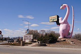
Vernal, the county seat and largest city in Uintah County, is in northeastern Utah, approximately 175 miles (280 km) east of Salt Lake City and 20 miles (32 km) west of the Colorado border. As of the 2020 census, the city population was 10,079. The population has since grown to 10,432 as of the 2022 population estimate.
Tinker's Creek, in Cuyahoga, Summit and Portage counties of Ohio, is the largest tributary of the Cuyahoga River, providing about a third of its flow into Lake Erie.
Black River is an 11.0-mile-long (17.7 km) river on the Upper Peninsula of the U.S. state of Michigan. The river flows into Lake Michigan at 46°05′37″N85°20′30″W, approximately 5 miles (8 km) east of Naubinway.

The Five Mile River is a 10.1-mile-long (16.3 km) river in central Massachusetts, part of the Chicopee River watershed. It rises north of Dean Pond in the Town of Oakham within Rutland State Forest and flows south through Dean Pond to Brooks Pond, 2.5 miles (4.0 km) northeast of North Brookfield, then continues south to its mouth at the north end of Lake Lashaway, also in North Brookfield.

Chase is an unincorporated community in Grant Township, Benton County, in the U.S. state of Indiana. Though virtually extinct, Chase still persists on state and county maps and retains a single business in the form of grain elevators operated by Boswell Chase Grain, Inc. A few miles away is the Daughtery Motor Speedway.

The Uinta Basin is a physiographic section of the larger Colorado Plateaus province, which in turn is part of the larger Intermontane Plateaus physiographic division. It is also a geologic structural basin in eastern Utah, east of the Wasatch Mountains and south of the Uinta Mountains. The Uinta Basin is fed by creeks and rivers flowing south from the Uinta Mountains. Many of the principal rivers flow into the Duchesne River which feeds the Green River—a tributary of the Colorado River. The Uinta Mountains form the northern border of the Uinta Basin. They contain the highest point in Utah, Kings Peak, with a summit 13,528 feet above sea level. The climate of the Uinta Basin is semi-arid, with occasionally severe winter cold.

The Flaming Gorge - Uintas Scenic Byway is a National Scenic Byway in the state of Utah. It spans approximately 80 miles (130 km) as it travels from Vernal, Utah northward through the Ashley National Forest and the Uintah Mountains to the area around Flaming Gorge National Recreation Area in the northeastern corner of the state.

Steinaker State Park is a state park and reservoir in Uintah County, Utah, United States, located 7 miles (11 km) north of Vernal.
Montezuma Creek is a tributary of the San Juan River. The stream is approximately 73 miles (117 km) long and is a seasonal river, becoming dry for several months of the year.
Henrys Fork is a 61-mile (98 km) long tributary of the Green River in Utah and Wyoming. Originating near Henrys Fork Peak in the Uinta Mountains of Utah, the river flows north into Wyoming, where it turns east, passing Lonetree, Burntfork, and McKinnon. Near Manila, Utah, the river loops back south into Utah, emptying into the Flaming Gorge Reservoir where it joins the Green River.

Laguña Creek also formerly also known as Tyende Creek, is a stream in the Navajo and Apache Counties of Arizona. Laguña Creek has its source at 36°41′15″N110°30′36″W, at the confluence of Long Canyon and Dowozhiebito Canyon at an elevation of 6,325 feet at the head of Tsegi Canyon. Its mouth is in the Chinle Valley at its confluence with Chinle Wash which together forms Chinle Creek, at an elevation of 4,774 feet. Chinle Creek is a tributary of San Juan River which is in turn a tributary of the Colorado River.

Chinle Creek is a tributary stream of the San Juan River in Apache County, Arizona and San Juan County, Utah. Its source is at 36°53′40″N109°44′37″W, the confluence of Laguña Creek and the Chinle Wash arroyo. Its name is derived from the Navajo word ch'inili meaning 'where the waters came out. Its sources is in Canyon de Chelly National Monument where Canyon de Chelly and Canyon del Muerto have their confluence at an elevation of 5,616 feet at 36°08′35″N109°29′17″W. It then trends northwest to its confluence with Laguña Creek where it forms Chinle Creek, 7 miles northeast of Dennehotso, Arizona at an elevation of 4,774 feet.
Crouse Creek is a stream in the Uinta Mountains near the eastern edge of Daggett County, Utah, United States.
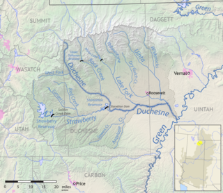
The Uinta River is a tributary of the Duchesne River flowing through Duchesne and Uintah counties in Utah, United States. Originating in the Uinta Mountains, the river flows southeast for about 60 miles (97 km) to join the Duchesne near Randlett. The Uinta is an important source of water for local irrigation. Its tributaries include the Whiterocks River, which joins it near Whiterocks, and the Dry Gulch Creek near Fort Duchesne.
Moniteau Creek is a stream in Cooper, Moniteau and Cole counties in central Missouri. It is a tributary of the Missouri River. The stream headwaters are in western Moniteau County just west of Tipton. The stream flows north into Cooper County then turns east and flows through the southeastern part of the county and re-enters Moniteau County. The stream continues meandering east passing under Missouri Route 87 south of Jamestown and enters the Missouri River floodplain in the Marion Bottoms Conservation Area between Sandy Hook to the north and Marion to the south. The confluence with the Missouri River floodplain lies in the northern tip of Cole County.
Gamma is an unincorporated community in northeast Montgomery County, in the U.S. state of Missouri. The community is at the intersection of Missouri Routes E and CC on the south side of Elkhorn Creek. Middletown is 5.5 miles to the northwest.
Boneta is an unincorporated community in east-central Duchesne County, Utah, United States.
References
- ↑ U.S. Geological Survey Geographic Names Information System: Ashley Creek (Utah)
- ↑ Leigh, Rufus Wood (1961). Five hundred Utah place names: their origin and significance. p. 3.
- ↑ Lund, Anthon Henrik (1922). The Utah Genealogical and Historical Magazine. Geneal. Society of Utah. p. 38.
40°20′30″N109°21′53″W / 40.34167°N 109.36472°W
| | This article related to a river in Utah is a stub. You can help Wikipedia by expanding it. |