Last updated Map showing the locations of Dorchester neighborhoods, including Ashmont
Ashmont is a section of the Dorchester neighborhood of Boston. It includes the subsections of Ashmont Hill, Peabody Square, and Ashmont-Adams. Located near the Milton/Boston border, major streets include Ashmont Street, Gallivan Blvd., and Dorchester Avenue.
The neighborhood was developed after Dorchester's annexation to Boston in 1870. The westerly side of the neighborhood, north of Fuller Street and west of Dorchester Avenue, north to Welles Avenue, was laid out on the former Welles estate. The more easterly side of the neighborhood, east of the station, south of Ashmont Street, and north of Minot Street and Van Winkle Street was developed by the Carruth family on their former estate.
The neighborhood is known for its larger Victorian style houses on the former estates with other side streets such as Fuller, Burt, Dracut, and Wrentham Streets having a denser two and three family development pattern. Dorchester Avenue in the area has an urban neighborhood commercial development pattern.
The MBTA has Red Line direct subway service to Downtown Boston, Harvard Square and other Cambridge locations (and ultimately to Alewife Station) at the Ashmont station and there is a link to the Mattapan Line trolley going to Mattapan.
The Red Line is a rapid transit line operated by the Massachusetts Bay Transportation Authority (MBTA) as part of the MBTA subway system. The line runs south and east underground from Alewife station in North Cambridge through Somerville and Cambridge, surfacing to cross the Longfellow Bridge then returning to tunnels under Downtown Boston. It continues underground through South Boston, splitting into two branches on the surface at JFK/UMass station. The Ashmont branch runs southwest through Dorchester to Ashmont station, where the connecting light rail Mattapan Line continues to Mattapan station. The Braintree branch runs southeast through Quincy and Braintree to Braintree station.
Dorchester is a neighborhood comprising more than 6 square miles (16 km2) in the City of Boston, Massachusetts, United States. Originally, Dorchester was a separate town, founded by Puritans who emigrated in 1630 from Dorchester, Dorset, England, to the Massachusetts Bay Colony. This dissolved municipality, Boston's largest neighborhood by far, is often divided by city planners in order to create two planning areas roughly equivalent in size and population to other Boston neighborhoods.
The Mattapan Line is a partially grade-separated light rail line which forms part of the MBTA's Red Line rapid transit line. The line, which runs through Boston and Milton, Massachusetts, opened on August 26, 1929, as a conversion of a former commuter rail line. It exclusively uses PCC streetcars built in the 1940s. Passengers must transfer at Ashmont to access the rest of the Red Line, which uses heavy rail metro rolling stock.
Mattapan is a neighborhood in Boston, Massachusetts, United States. Mattapan is the original Native American name for the Dorchester area, possibly meaning "a place to sit." At the 2010 census, it had a population of 36,480, with the majority of its population immigrants.
Key bus routes of the Massachusetts Bay Transportation Authority (MBTA) system were the 15 routes that had high ridership and higher frequency standards than other bus lines, according to the 2004 MBTA Service Policy. Together, they accounted for roughly 40% of the MBTA's total bus ridership. These key bus routes ensured basic geographic coverage with frequent service in the densest areas of Boston, and connected to other MBTA services to give access to other areas throughout the region.
Dorchester Avenue is a street in Boston, Massachusetts, running from downtown south via South Boston and Dorchester to the border with Milton, where it ends. Built as a turnpike, the Dorchester Turnpike, it is mostly straight.
As with many large cities, a large number of Boston-area streetcar lines once existed, and many continued operating into the 1950s. However, only a few now remain, namely the four branches of the Green Line and the Mattapan Line, with only one running regular service on an undivided street.
Fields Corner station is a rapid transit station on the Ashmont branch of the Massachusetts Bay Transportation Authority (MBTA) Red Line, located in the Fields Corner district of Dorchester, Boston, Massachusetts. It is a major transfer point for MBTA bus service, serving routes 15, 17, 18, 19, 201, 202,and210. The station opened in 1927 and was completely rebuilt from 2004 to 2008, making it fully accessible.
Ashmont station is a Massachusetts Bay Transportation Authority (MBTA) intermodal transit station located at Peabody Square in the Dorchester neighborhood of Boston, Massachusetts. It is the southern terminus of the Ashmont branch of the rapid transit Red Line, the northern terminus of the connecting light rail Mattapan Line, and a major terminal for MBTA bus service. Ashmont has two side platforms serving the below-grade Red Line and a single side platform on an elevated balloon loop for the Mattapan Line. The station is fully accessible for all modes.
Mattapan station is an MBTA light rail station in Boston, Massachusetts. It is the southern terminus of the Mattapan Line, part of the Red Line, and is also an important MBTA bus transfer station, with eight routes terminating there. It is located at Mattapan Square in the Mattapan neighborhood. At the station, streetcars use a balloon loop to reverse direction back to Ashmont station. Mattapan station is fully accessible, with mini-high platforms.
Boston's diverse neighborhoods serve as a political and cultural organizing mechanism. The City of Boston's Office of Neighborhood Services has designated 23 Neighborhoods in the city:
Savin Hill station is a rapid transit station in Boston, Massachusetts. It serves the Ashmont branch of the MBTA's Red Line. It is located at 121 Savin Hill Avenue adjacent to Sydney Street in the Savin Hill area of the Dorchester neighborhood. Opened in 1845 as a commuter rail station, Savin Hill was converted to rapid transit in 1927 and rebuilt in 2004–05 for accessibility. Averaging 2,199 daily boardings by a FY 2019 count, Savin Hill is the least-used station on the Red Line.
The Parish of All Saints, Ashmont, is a church of the Episcopal Diocese of Massachusetts located at 209 Ashmont Street in the Dorchester neighborhood of Boston, Massachusetts. Built 1892-1929 for a congregation founded in 1867, it was the first major commission of architect Ralph Adams Cram, a major influence in the development of early 20th-century Gothic church and secular architecture. The church was listed on the National Register of Historic Places in 1980, and is protected by a preservation easement held by Historic New England.
Shawmut station is a subway station in Boston, Massachusetts. It serves the Ashmont branch of the MBTA's Red Line. It is located on Dayton Street in the Dorchester neighborhood. The station, the only underground station on the Red Line south of Andrew station, sits in a shallow cut-and-cover subway tunnel that runs from Park Street south to Peabody Square where it surfaces at Ashmont station. Shawmut opened along with Ashmont on September 1, 1928, as part of a southward extension of the Cambridge–Dorchester line.
Butler station is a light rail station in Boston, Massachusetts. It serves the MBTA Mattapan Line. It is located at Butler Street in the Lower Mills section of the Dorchester neighborhood. It serves a small residential area sandwiched between the Neponset River, Cedar Grove Cemetery, and Dorchester Park. Butler station has no MBTA bus connections. It is accessible via a wooden mini-high ramp on the station's single island platform.
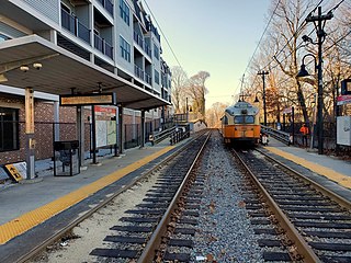
Central Avenue station is a light rail station located off Central Avenue near Eliot Street in Milton, Massachusetts. It serves the Mattapan Line, a branch of the MBTA Red Line. Central Avenue consists of two side platforms which serve the Ashmont–Mattapan High Speed Line's two tracks.
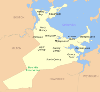
West Quincy is a neighborhood of Quincy, Massachusetts. It is bordered on the north by Wollaston, on the east by Quincy Center, on the south by South Quincy and on the west by the town of Milton and the Blue Hills Reservation.
The Dorchester and Milton Branch Railroad was a railroad in Massachusetts. It ran between Neponset Village in Dorchester, Massachusetts, through the town of Milton to the village of Mattapan. It was opened in 1847 and became part of the Old Colony Railroad system in 1848. The western portion was converted to a streetcar line in 1929, while the eastern portion remained in use for freight until the 1980s.
Fields Corner is a historic commercial district in Dorchester, the largest neighborhood in Boston, Massachusetts, United States founded in June 1630.
Meeting House Hill is one of the oldest sections of Boston's historic Dorchester neighborhood. It is the site of the First Parish Church and the Mather School, the oldest public elementary school in North America. Located immediately to the north of Fields Corner, it is within walking distance of the Fields Corner and Savin Hill MBTA stations.
This page is based on this Wikipedia article Text is available under the CC BY-SA 4.0 license; additional terms may apply. Images, videos and audio are available under their respective licenses.