Trarza is a region in southwest Mauritania. Its capital is Rosso. Other major cities and towns include Mederdra and Boutilimit. Trarza borders the regions of Inchiri and Adrar to the north, Brakna to the east, and the country of Senegal to the south. Its western coastline on the Atlantic Ocean is interrupted only by the Mauritanian capital Nouakchott, which the region completely surrounds.

Adrar is a large administrative region in Mauritania, named for the Adrar Plateau. The capital is Atar. Other major towns include Choum, Chinguetti and Ouadane. The region borders Western Sahara and the Mauritanian region of Tiris Zemmour to the north, Mali and the Mauritanian region of Hodh Ech Chargui to the east, the Mauritanian regions of Trarza and Tagant to the south and the Mauritanian region of Inchiri to the west.

Atar is a town in northwestern Mauritania, the capital of the Adrar Region and the main settlement on the Adrar Plateau. Situated on the oued Seguellil, it is home to an airport, a museum and a historic mosque, constructed in 1674.

The Adrar is a highland natural and historical region of the Sahara Desert in northern Mauritania. The Adrar Region, an administrative division of Mauritania, is named after the traditional region. It is sometimes called Adrar Tamar to distinguish it from other areas called Adrar in the Sahara.
Ben Amera is Africa's largest monolith, rising 633m (2027ft) above the desert floor. It's the world's second largest monolith only behind Uluru, in Australia. Ben Amera is located in Mauritania, near the border with Western Sahara. It lies 4km north of the train track where the famous Iron Ore Train travels between Nouâdibhou and Choûm.

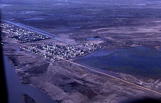
Choum is a town in northern Mauritania, lying in the Adrar Region close to the border with Western Sahara.
Aoujeft or Oujeft is a town and commune in the Adrar Region of western Mauritania.
Articles related to Mauritania include:

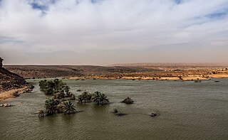
Terjit is an oasis, 45km by road south of Atar and popular with tourists in Mauritania. It nestles in a gorge on the western edge of the Adrar plateau with the palm grove stretching a few hundred meters alongside a stream which emerges from a spring. Terjit is part of the commune of Maaden in the Aoujeft Department.

The Emirate of Trarza was a pre-colonial state in what is today southwest Mauritania. It has survived as a traditional confederation of semi-nomadic people to the present day. Its name is shared with the modern Region of Trarza. The population, a mixture of Berber tribes, had been there for a long time before being conquered in the 11th century by Hassaniya Arabic speakers from the north.

Atar Airport or Atar International Airport is an airport serving Atar, a town in the Adrar Region of Mauritania.

Chinguetti is a department of the Adrar Region in Mauritania. The capital lies at Chinguetti, an ex-Middle Ages center for trade which is considered to be a ghost town. The other village in this mostly desert-area department is Ain Savra.

Amojjar Pass is a mountain pass in the Adrar Plateau in the centre of Adrar, near Atar, Mauritania. The pink-brown sandstone of the pass was worn away by repeated cycles of extreme dryness interrupted by torrential rain. The bases of the steep valley walls are covered in scree, loosed by the erosion of the rainfall. There is little plant life in the pass. Acacias are a notable exception, as they are resistant to drought.
Ain Ehel Taya is a town and commune in the Adrar Region of Mauritania. Its current mayor is Mohamed Ely Cheinoune.

Aoujeft is one of the four departments of the wider Adrar Region, in western Mauritania. The capital lies at Aoujeft.
ASC Imraguens is a Mauritanean football club based in Atar, Mauritania the capital of the Adrar Region. The club plays in the Mauritanian top division.
The Socialist Union of Mauritanian Muslims was a political party in Mauritania. The party was founded in February 1960. Achmed Ould Kerkoub was the leader of the party.

Mhaïreth or M'Heirth is one of the largest oases of the Adrar region in Mauritania. It is located near Terjit. Mhaïreth is part of the commune of Maaden in the Aoujeft Department.
Oued Seguellil is a wadi in Mauritania. It begins in the Adrar Plateau and runs south-west passing through the town of Atar and getting lost in the surrounding sands.

