Athol Junction

Last updated

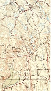
Athol Junction is a place in Springfield, Massachusetts, named after the rail line that split off to Athol, Massachusetts, before The Quabbin Reservoir was flooded. It is located next to I-291 and the tracks now are used for the industrial park and extend to Indian Orchard before stopping. When the line was active the tracks extended over the Chicopee River, into Ludlow, Massachusetts, and on to Athol.

Springfield, Massachusetts City in Massachusetts

Springfield is a city in the state of Massachusetts, United States, and the seat of Hampden County. Springfield sits on the eastern bank of the Connecticut River near its confluence with three rivers: the western Westfield River, the eastern Chicopee River, and the eastern Mill River. As of the 2010 Census, the city's population was 153,060. As of 2017, the estimated population was 154,758, making it the third-largest city in Massachusetts, the fourth-most populous city in New England after Boston, Worcester, and Providence, and the 12th-most populous in the Northeastern United States. Metropolitan Springfield, as one of two metropolitan areas in Massachusetts, had a population of 692,942 as of 2010.

Athol, Massachusetts Town in Massachusetts, United States

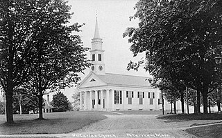
Athol is a town in Worcester County, Massachusetts, United States. The population was 11,584 at the 2010 census.

Quabbin Reservoir

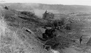
The Quabbin Reservoir is the largest inland body of water in Massachusetts, and was built between 1930 and 1939. Today, along with the Wachusett Reservoir, it is the primary water supply for Boston, some 65 miles (105 km) to the east as well as 40 other communities in Greater Boston. It also supplies water to three towns west of the reservoir and acts as backup supply for three others. It has an aggregate capacity of 412 billion US gallons (1,560 GL) and an area of 38.6 square miles (99.9 km2).

The Athol and Enfield Railroad and the Springfield and North-Eastern Railroad were chartered in 1869, and succeeded by the Springfield, Athol and Northeastern Railroad in 1872, opening in 1873 as a branch from Athol Junction in Springfield to the Vermont and Massachusetts Railroad in Athol. The B&A bought the line in 1880. The majority of the line was closed in the 1930s due to the formation of the Quabbin Reservoir.

Springfield, Athol and North-eastern Railroad

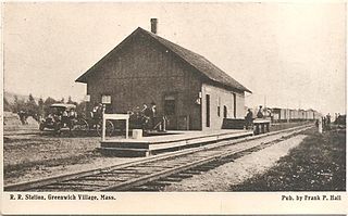
The Springfield, Athol and North–eastern Railroad was a railroad that operated in the northeast United States in the 19th century.

Boston and Albany Railroad

The Boston and Albany Railroad was a railroad connecting Boston, Massachusetts to Albany, New York, later becoming part of the New York Central Railroad system, Conrail, and CSX Transportation. The line is currently used by CSX for freight. Passenger service is still operated on the line by Amtrak, and by the MBTA Commuter Rail system, which owns and uses the section east of Worcester as their Framingham/Worcester Line.

Related Research Articles

New Salem, Massachusetts Town in Massachusetts, United States

New Salem is a town in Franklin County, Massachusetts, United States. The population was 990 at the 2010 census. It is part of the Springfield, Massachusetts Metropolitan Statistical Area.

Ludlow, Massachusetts Town in Massachusetts, United States

Ludlow is a New England town in Hampden County, Massachusetts, United States. The population was 21,103 as of the 2010 census, and it is considered part of the Springfield Metropolitan Statistical Area. Located just northeast of Springfield across the Chicopee River, it is one of the city's suburbs. It has a sizable and visible Portuguese community.

Petersham, Massachusetts Town in Massachusetts, United States

Petersham is a town in Worcester County, Massachusetts, United States. The population was 1,234 at the 2010 census. Petersham is home to a considerable amount of conservation land, including the Quabbin Reservation, Harvard Forest, the Swift River Reservation, and Federated Women's Club State Forest.

Belchertown, Massachusetts Town in Massachusetts, United States

Belchertown is a town in Hampshire County, Massachusetts, United States. It is part of the Springfield, Massachusetts Metropolitan Statistical Area. The population was 14,649 at the 2010 census. The town includes the census-designated place of Belchertown. Belchertown was formerly the home of the Belchertown State School. The land on which the school sat is, as of 2016, being redeveloped for mixed uses including residential, commercial and recreational. This includes the 385-acre Lampson Brook Farm, used for community and sustainable agriculture, outdoor recreation, and wildlife preservation.

Ware, Massachusetts Town in Massachusetts, United States

Ware is a town in Hampshire County, Massachusetts, United States. The population was 9,872 at the 2010 census. It is part of the Springfield, Massachusetts Metropolitan Statistical Area.

Enfield, Massachusetts Town in Massachusetts, United States

Enfield was a town in Hampshire County, Massachusetts. The town was lost as a result of the creation of the Quabbin Reservoir.

Western Massachusetts

Western Massachusetts is a region in Massachusetts, one of the six U.S. states that make up the New England region of the United States. Western Massachusetts has diverse topography; 22 universities, with approximately 100,000 university students; and such institutions as Tanglewood, the Springfield Armory, and Jacob's Pillow.

Greenwich, Massachusetts Town in Massachusetts, United States

Greenwich was a town in Hampshire County, Massachusetts. The town was lost as a result of the formation of the Quabbin Reservoir in order to supply Boston's growing water needs.

Cleveland Circle, an area of Boston, Massachusetts, is located in Boston's Brighton neighborhood, and more specifically the Aberdeen section of Brighton, in very close proximity to Brookline and Chestnut Hill, Massachusetts, at the intersection of Beacon Street and Chestnut Hill Avenue.

Central Massachusetts Railroad

The Central Massachusetts Railroad was a railroad in Massachusetts. The eastern terminus of the line was at North Cambridge Junction where it split off from the Middlesex Central Branch of the Boston and Lowell Railroad in North Cambridge and through which it had access to North Station in Boston. From there, the route ran 98.77 miles west through the modern-day towns of Belmont, Waltham, Weston, Wayland, Sudbury, Hudson, Bolton, Berlin, Clinton, West Boylston, Holden, Rutland, Oakham, Barre, New Braintree, Hardwick, Ware, Palmer, Belchertown, Amherst, and Hadley to its western terminal junction at N. O. Tower in Northampton with the Connecticut River Railroad.

Quabbin–Swift River Valley

The Quabbin Valley is a region of Massachusetts in the United States. The region consists of areas drained by the Quabbin Reservoir and accompanying river systems in Franklin, Hampden, Hampshire, and Worcester counties. The area is sometimes known as the Swift River Valley region, a reference to the Swift River, which was dammed to form the reservoir.

Carrick Island (Massachusetts) island in the United States of America

Carrick Island is a small island in the Quabbin Reservoir in Massachusetts, roughly 600 feet (180 m) by 300 feet (91 m). It is part of the Town of Petersham, in Worcester County. The island lies just west of the much larger Mount Zion Island, the largest island in the reservoir.

Massachusetts Route 2A highway in Massachusetts

Route 2A exists in several sections of Massachusetts, mainly as parts of former Route 2 that have been moved or upgraded. Route 2A runs from Greenfield in the west to Boston in the east. It formerly extended to Shelburne Falls in Buckland in the west, but as of 2007, the route terminates at Interstate 91 in Greenfield.

Ware River Diversion

The Ware River Diversion is a dam on the Ware River. It is part of the Boston, Massachusetts public water supply system, maintained by the Massachusetts Water Resources Authority (MWRA). It is located in Worcester County in the town of Barre, close to its border with Oakham.

Broad Brook Canal

The Broad Brook Canal is a water-supply canal feeding the Springfield Reservoir in Ludlow, Massachusetts, a public water supply for the city of Springfield, Massachusetts. Its northern segment is also known as the Jabish Canal.

Massachusetts Route 21 highway in Massachusetts

Route 21 is a south–north state highway in Massachusetts that runs between Springfield and Belchertown.

References

    Coordinates: 42°7′53.64″N72°33′31.23″W / 42.1315667°N 72.5586750°W / 42.1315667; -72.5586750

    Geographic coordinate system Coordinate system

    A geographic coordinate system is a coordinate system that enables every location on Earth to be specified by a set of numbers, letters or symbols. The coordinates are often chosen such that one of the numbers represents a vertical position and two or three of the numbers represent a horizontal position; alternatively, a geographic position may be expressed in a combined three-dimensional Cartesian vector. A common choice of coordinates is latitude, longitude and elevation. To specify a location on a plane requires a map projection.