This article is missing information about the river.(February 2019) |
Atirro River is a river of Costa Rica. [1]
This article is missing information about the river.(February 2019) |
Atirro River is a river of Costa Rica. [1]

Alcona Township is a civil township of Alcona County in the U.S. state of Michigan. The population was 966 at the 2020 census.

Frenchtown Charter Township is a charter township within Monroe County in the U.S. state of Michigan. The population was 21,609 as per the 2020 census.
Springfield Charter Township is a charter township of Oakland County in the U.S. state of Michigan. As of the 2020 census, the township population was 14,703. The township was named for the numerous springs in the area.

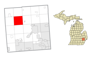
Ypsilanti Charter Township is a charter township of Washtenaw County in the U.S. state of Michigan. The population was 55,670 at the 2020 census. The city of Ypsilanti is mostly surrounded by the township, but the two are administered autonomously.

Van Buren Township is a charter township in Wayne County in the U.S. state of Michigan. A western suburb of Detroit, Van Buren Township is located roughly 28 miles (45.1 km) southwest of downtown Detroit, and 17 miles (27.4 km) southeast of Ann Arbor. As of the 2020 census, the township had a population of 30,375. It surrounds, but is independent of, the city of Belleville.

Maumee Bay on Lake Erie is located in the U.S. state of Ohio, just east of the city of Toledo. The bay and the surrounding wetlands form most of the Maumee River basin, and in 1975 part of the area was incorporated into Maumee Bay State Park. The park is not huge, covering 1,450 acres (5.9 km2), but its wetlands feature some of the best bird watching in the United States. The Maumee Bay area is a popular vacation spot in the Midwest, featuring several resorts and a golf course.
Thunder Bay is a bay in the U.S. state of Michigan on Lake Huron. The bay extends from North Point at 45°01′19″N83°15′58″W to South Point at 44°53′00″N83°18′51″W.

The River Swale in Yorkshire, England, is a major tributary of the River Ure, which becomes the River Ouse, that empties into the North Sea via the Humber Estuary. The river gives its name to Swaledale, the valley through which it flows.
The Foothills Parkway is a national parkway which traverses the foothills of the northern Great Smoky Mountains in East Tennessee, located in the southeastern United States. The 72.1-mile (114 km) parkway will connect U.S. Route 129 along the Little Tennessee River in the west with Interstate 40 (I-40) along the Pigeon River in the east.
North Georgia is the northern hilly/mountainous region in the U.S. state of Georgia. At the time of the arrival of settlers from Europe, it was inhabited largely by the Cherokee. The counties of north Georgia were often scenes of important events in the history of Georgia. It was the site of many American Civil War battles, including the Battle of Lookout Mountain and the Battle of Chickamauga, leading up to the Atlanta Campaign. Today, particularly in the northeast portion of the region, tourism sustains the local economy.
The Cass River is a 61.5-mile-long (99.0 km) river in the Thumb region of the U.S. state of Michigan. It drains large portions of Sanilac and Tuscola counties and smaller portions of Genesee, Huron, Lapeer, and Saginaw counties.

The Alapaha River is a 202-mile-long (325 km) river in southern Georgia and northern Florida in the United States. It is a tributary of the Suwannee River, which flows to the Gulf of Mexico.

The Withlacoochee River originates in Georgia, northwest of Nashville, Georgia. It flows south through Berrien County where it joins the New River and forms part of the boundary between Berrien and Cook counties. It then flows south into Lowndes County, Georgia. At Troupville, Georgia the Little River joins the Withlacoochee River flows continues to flow south and forms part of the boundary between Lowndes and Brooks counties in Georgia. The river then flows into Florida for 1.34 miles before returning into Georgia for an additional 2.44 miles. It then returns to Florida, forming the northeast boundary of Madison County, Florida and the western boundary of Hamilton County, Florida and eventually merges with the Suwannee at Suwannee River State Park west of Live Oak. The river is 115 miles (185 km) long.
Raven Rock is a sandstone protrusion in the Daniel Boone National Forest, overlooking Kentucky's Red River within the Red River Gorge. The rock is over 1,280 feet tall and has massive cliffs on three sides. Although there is no official trail to the top, it can be accessed by a paved road where a past owner tried to bring tourism to the summit. The view from the top of Raven Rock is one of the most spectacular in the area.
The Alapahoochee River is a 14.4-mile-long (23.2 km) tributary of the Alapaha River in Georgia and Florida in the United States. Via the Alapaha and Suwannee rivers, its waters flow to the Gulf of Mexico.
The South River is a 63.5-mile-long (102.2 km) tributary of the Ocmulgee River in the U.S. state of Georgia. It originates in the city of East Point in Fulton County and eventually flows into Lake Jackson, joining the Yellow River and Alcovy River to form the Ocmulgee.

Lotts Creek is a creek in Perry County and Knott County, Kentucky in the United States. It is a tributary of the North Fork Kentucky River that joins it at Darfork 3 miles (4.8 km) downstream of Hazard at an altitude of 820 feet (250 m). It is 8.5 miles (13.7 km) long from its mouth to where it splits into the Young's and Kelly Forks.
Trace Fork or Trace Branch is a creek in Perry County, Kentucky in the United States. It a fork of Lotts Creek 1 mile (1.6 km) upstream from the latter's mouth at an altitude of 825 feet (251 m).
9°54′53.14″N83°41′27.24″W / 9.9147611°N 83.6909000°W