Related Research Articles

Cornwall is a ceremonial county in South West England. It is recognised by Cornish and Celtic political groups as one of the Celtic nations, and is the homeland of the Cornish people. The county is bordered by the Atlantic Ocean to the north and west, Devon to the east, and the English Channel to the south. The largest settlement is Falmouth, and the county town is the city of Truro.
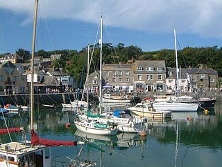
Padstow is a town, civil parish and fishing port on the north coast of Cornwall, England, United Kingdom. The town is situated on the west bank of the River Camel estuary, approximately 5 miles (8.0 km) northwest of Wadebridge, 10 miles (16 km) northwest of Bodmin and 10 miles (16 km) northeast of Newquay. The population of Padstow civil parish was 3,162 in the 2001 census, reducing to 2,993 at the 2011 census. In addition an electoral ward with the same name exists but extends as far as Trevose Head. The population for this ward is 4,434.

Newquay is a town on the north coast in Cornwall, England, United Kingdom. It is a civil parish, seaside resort, regional centre for aerospace industries with an airport and a spaceport, and a fishing port on the North Atlantic coast of Cornwall, approximately 12 miles (19 km) north of Truro and 20 miles (32 km) west of Bodmin.

The South West Coast Path is England's longest waymarked long-distance footpath and a National Trail. It stretches for 630 miles (1,014 km), running from Minehead in Somerset, along the coasts of Devon and Cornwall, to Poole Harbour in Dorset. Because it rises and falls with every river mouth, it is also one of the more challenging trails. The total height climbed has been calculated to be 114,931 ft (35,031 m), almost four times the height of Mount Everest. It has been voted 'Britain's Best Walking route' twice in a row by readers of The Ramblers' Walk magazine, and regularly features in lists of the world's best walks.
Bude is a seaside town in north Cornwall, England, United Kingdom, in the civil parish of Bude-Stratton and at the mouth of the River Neet. It was sometimes formerly known as Bude Haven. It lies southwest of Stratton, south of Flexbury and Poughill, and north of Widemouth Bay, located along the A3073 road off the A39. Bude is twinned with Ergué-Gabéric in Brittany, France. Bude's coast faces Bude Bay in the Celtic Sea, part of the Atlantic Ocean. The population of the civil parish can be found under Bude-Stratton.

The Bristol Channel is a major inlet in the island of Great Britain, separating South Wales and South West England. It extends from the smaller Severn Estuary of the River Severn to the North Atlantic Ocean. It takes its name from the English city and port of Bristol.

Perranporth is a seaside resort town on the north coast of Cornwall, England, United Kingdom. It is 2.1 miles east of the St Agnes Heritage Coastline, and around 7 miles south-west of Newquay. Perranporth and its 2 miles (3 km) long beach face the Atlantic Ocean. It has a population of 3,066, and is the largest settlement in the civil parish of Perranzabuloe. It has an electoral ward in its own name whose population was 4,270 in the 2011 census.

North Cornwall is an area of Cornwall, England, United Kingdom. It is also the name of a former local government district, which was administered from Bodmin and Wadebridge 50.516°N 4.835°W. Other towns in the area are Launceston, Bude, Padstow, and Camelford.

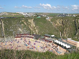
Fistral Beach is in Fistral Bay on the north coast of Cornwall, England, United Kingdom. It is situated half a mile west of Newquay at grid reference SW 797 620.
Pentire Head is a headland and peninsula on the Atlantic coast in North Cornwall, England, and is about one mile square. The headland projects north-west with Pentire Point at its north-west corner and The Rumps promontory at its north-east corner.

Crackington Haven is a coastal village in Cornwall, England, United Kingdom. It is in the civil parish of St Gennys at grid reference SX140972 at the head of a cove on the Atlantic coast. The village is seven miles (11 km) south-southwest of Bude and four miles (7 km) north-northeast of Boscastle.

Watergate Bay is a long bay or beach flanked by cliffs centred two miles NNE of Newquay below the B3276 Newquay to Padstow road near the hamlet of Tregurrian in Cornwall, United Kingdom. It faces the Atlantic Ocean, adjacent to Newquay Bay. The 2-mile (3.2 km) sandy beach and exposed site is popular for non-powered water sports, kite flying, and sand art.

The geology of Cornwall, England, is dominated by its granite backbone, part of the Cornubian batholith, formed during the Variscan orogeny. Around this is an extensive metamorphic aureole formed in the mainly Devonian slates that make up most of the rest of the county. There is an area of sandstone and shale of Carboniferous age in the north east, and the Lizard peninsula is formed of a rare section of uplifted oceanic crust.

The Headland Hotel is a Grade II listed building located in Newquay, Cornwall, England, United Kingdom. It was opened in June 1900 and is built on a prominent position overlooking Fistral Beach and Towan Head.

Cornwall's rugged landscape and scenery have been used by film and television companies as a backdrop for some of their productions.

Mawgan Porth is a beach and small settlement in north Cornwall, England. It is north of Watergate Bay, approximately four miles (6 km) north of Newquay, on the Atlantic Ocean coast.
Lusty Glaze also known as Lusty Glaze Beach, is a beach in Newquay, Cornwall.
St Gennys is a coastal civil parish and small settlement in north Cornwall, England, United Kingdom.
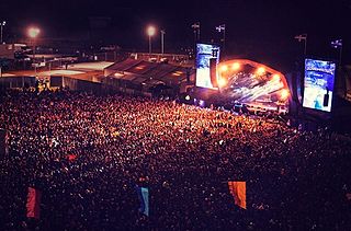
Boardmasters Festival is an annual event held in Cornwall, United Kingdom, usually spanning five days on the second weekend of August. The event is a combination of live music and surfing/skateboarding competitions in and around the town of Newquay. The festival was founded in 1981 as a surfing competition, and in 2005 it was expanded to include music acts, taking place at Watergate Bay. The current capacity is 53,000.

Kelsey Head is a coastal Site of Special Scientific Interest (SSSI) and headland in north Cornwall, England, UK, noted for its biological interest. The site contains an Iron Age hill fort.
References
- ↑ "Cornwall Waverunner Safaris | Newquay Surf School | Newquay |". www.cornwallwaverunnersafaris.co.uk/activities/private-surf-lessons-newquay/. Retrieved 20 April 2023.
- ↑ "Fistral Beach Surf School | International Surfing Centre | Newquay |". www.fistralbeachsurfschool.co.uk. Retrieved 10 September 2017.
- ↑ Ltd, Copyright The Beach Guide - A-Connect. "Fistral surfing information". UK Beach Guide. Retrieved 10 September 2017.
- ↑ "Newquay Activity Centre | Surf School | Newquay |". newquayactivitycentre.co.uk. Retrieved 10 April 2024.
- ↑ "Surfing Events - Newquay". www.visitnewquay.org. Retrieved 10 September 2017.
- ↑ "The North Cornwall coast". www.visitcornwall.com. Retrieved 10 September 2017.
- ↑ "Walking the Cornwall Coastal Footpath - High Cliff to Crackington Haven". www.cornwallinfocus.co.uk. Retrieved 17 September 2017.
| | This Cornwall location article is a stub. You can help Wikipedia by expanding it. |