
Johann Heinrich Daniel Zschokke was a German, later Swiss, author and reformer. Most of his life was spent, and most of his reputation earned, in Switzerland. He had an extensive civil service career, and wrote histories, fiction and other works which were widely known.

The Swiss mercenaries were a powerful infantry force constituted by professional soldiers originating from the cantons of the Old Swiss Confederacy. They were notable for their service in foreign armies, especially among the military forces of the kings of France, throughout the early modern period of European history, from the Late Middle Ages into the 19th century. Their service as mercenaries was at its peak during the Renaissance, when their proven battlefield capabilities made them sought-after mercenary troops. There followed a period of decline, as technological and organizational advances counteracted the Swiss' advantages. Switzerland's military isolationism largely put an end to organized mercenary activity; the principal remnant of the practice is the Pontifical Swiss Guard at the Vatican.

Guillaume Henri Dufour was a Swiss military officer, structural engineer and topographer. He served under Napoleon I and held the Swiss office of General four times in his career, firstly in 1847 when he led the Swiss Confederation forces to victory against the Sonderbund. In 1864 Dufour presided over the First Geneva Convention which established the International Red Cross. He was founder and president of the Swiss Federal Office of Topography.
As there is no dominant national language, the four main languages of French, Italian, German and Romansh form the four branches which make up a literature of Switzerland. The original Swiss Confederation, from its foundation in 1291 up to 1798, gained only a few French-speaking districts in what is now the Canton of Fribourg, and so the German language dominated. During that period the Swiss vernacular literature was in German, although in the 18th century, French became fashionable in Bern and elsewhere. At that time, Geneva and Lausanne were not yet Swiss: Geneva was an ally and Vaud a subject land. The French branch does not really begin to qualify as Swiss writing until after 1815, when the French-speaking regions gained full status as Swiss cantons. The Italian and Romansch-Ladin branches are less prominent.
Heinrich August Wilhelm Meyer was a German Protestant divine. He wrote commentaries on the New Testament and published an edition of that book.

Johann Caspar Füssli was a Swiss portrait painter and art historian.
Landammann, is the German title used by the chief magistrate in certain Cantons of Switzerland and at times featured in the Head of state's style at the confederal level.
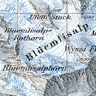
The cartography of Switzerland is the history of surveying and creation of maps of Switzerland. Switzerland has had its current boundaries since 1815, but maps of the Old Swiss Confederacy were drawn since the 16th century. The first topographical survey on a federal level began in 1809, resulting in the Topographic Map of Switzerland or Dufour Map. From 1869 to 1901, this map was replaced by the Topographic Atlas of Switzerland or Siegfried Map.

Hottinger first appears in the annals of the town of Zöllikon, near Zurich, in 1362. The town had recently joined the Swiss Confederation, and was poised to become a thriving center for trade. In 1401, three members of the Hottinger family were named Grand Burghers of the city. Their names Hans, Heinrich and Rudolf – or, in their French variants, Jean, Henri and Rodolphe – have marked the family dynasty for over 500 years. During the 15th and 16th centuries, their descendants oversaw the canton's progressive transformation from a rural to a financial economy, taking an active role in the region's political, cultural and religious life all the way into the 18th century.

The historiography of Switzerland is the study of the history of Switzerland.
Johann Heinrich Meyer was a Swiss painter, engraver and art critic. He served as the second Director of the Weimar Princely Free Drawing School. A close associate of Johann Wolfgang von Goethe, he was often referred to as "Goethemeyer".

The Topographic Map of Switzerland, also known as the Dufour Map is a 1:100 000 scale map series depicting Switzerland for the first time based on accurate geometric measurements. It is also the oldest official map series of Switzerland.
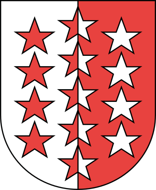
The coat of arms of the Swiss canton of Valais is in red and white, divided vertically with thirteen five-pointed stars in opposite colours. The stars represent the thirteen districts. It was introduced in 1815, when the Valais was detached from the French Department of Simplon to join the join the Swiss Confederacy.
The Helvetische Gesellschaft / Société Helvétique, or Helvetic Society as it is known in English, was a patriotic society and the first Swiss reform society. It was founded by Swiss philosopher Isaak Iselin, poet Solomon Gessner and some 20 others on 15 May 1762, and was dissolved with the formation of the Helvetic Republic in 1798. It was revived again from 1819 on until 1849. The latter should not be confused with the contemporary Helvetic Society for the Natural Sciences, established in 1815.

Christian von Mechel was a Swiss engraver, publisher and art dealer. He developed a broad trade in art, through business connections throughout northern and central Europe; although the French Revolutionary Wars ruined him financially, he started over in 1805 in Berlin.

Pfyffer is a Swiss family and surname, originally members of the patriciate of the city of Lucerne. Several generations of representatives of this family were commanders of the Pontifical Swiss Guard, The Pfyffer family was the most powerful family in Lucerne during the early modern period. In the later 16th century it was divided into the lineages Pfyffer von Altishofen, Pfyffer von Wyher and Pfyffer von Heidegg after their respective seats in Altishofen, Wyher (Ettiswil) and Heidegg (Hitzkirch). The two latter branches are extinct and the modern Pfyffer surname indicates membership in the Pfyffer von Altishofen family.

Rudolf Leuzinger was a Swiss cartographer. He is known as one of the most prolific cartographers in Switzerland and one of the best interpreters of mountain landscapes and geologic forms. Leuzinger was also the first to produce terrain maps in color lithography. His more than 300 maps are a rare combination of accuracy, scientific thoroughness and artistry and earned him several national and international honors.

Rudolf Füssli was a Swiss painter, art historian and lexicographer.
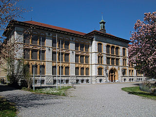
The old cantonal school of Aarau was founded in 1802 and is the oldest non-church secondary school in Switzerland.
