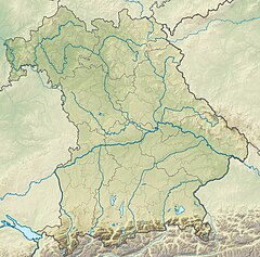
Bavaria, officially the Free State of Bavaria, is a state in the southeast of Germany. With an area of 70,550.19 km2 (27,239.58 sq mi), it is the largest German state by land area, comprising roughly a fifth of the total land area of Germany, and with over 13.08 million inhabitants, it is the second most populous German state, behind only North Rhine-Westphalia; however, due to its large land area, its population density is below the German average. Major cities include Munich, Nuremberg, and Augsburg.

The Palatinate, or the Rhenish Palatinate (Rheinpfalz), is a historical region of Germany. The Palatinate occupies most of the southern quarter of the German federal state of Rhineland-Palatinate (Rheinland-Pfalz), covering an area of 2,105 square miles (5,450 km2) with about 1.4 million inhabitants. Its residents are known as Palatines (Pfälzer).

Swabia is one of the seven administrative regions of Bavaria, Germany. It consists of ten districts and 340 municipalities with Augsburg being the administrative capital. It is the only german region officially be named Swabia in the principle of spatiality.

Upper Franconia is a Regierungsbezirk of the state of Bavaria, southern Germany. It forms part of the historically significant region of Franconia, the others being Middle Franconia and Lower Franconia, which are all now part of the German Federal State of Bayern (Bavaria).
Aichach-Friedberg is a Landkreis (district) in Bavaria, Germany. It is bounded by the districts of Augsburg, Donau-Ries, Neuburg-Schrobenhausen, Pfaffenhofen, Dachau, Fürstenfeldbruck and Landsberg, as well as by the city of Augsburg.

Upper Bavaria is one of the seven administrative regions of Bavaria, Germany.

Lower Bavaria is one of the seven administrative regions of Bavaria, Germany, located in the east of the state. It consists of nine districts and 258 municipalities.
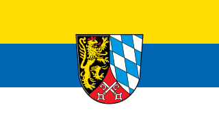
The Upper Palatinate is an administrative district in the east of Bavaria, Germany. It consists of seven districts and 226 municipalities, including three cities.

The Iller is a river of Bavaria and Baden-Württemberg in Germany. It is a right tributary of the Danube, 146 kilometres (91 mi) long.
Altötting is a Landkreis (district) in Bavaria, Germany. It is bounded by Austria and the Bavarian districts of Traunstein, Mühldorf and Rottal-Inn.
Cham is a Landkreis (district) in Bavaria, Germany. It is bounded by the districts of Regen, Straubing-Bogen, Regensburg and Schwandorf and by the Czech Plzeň Region.

The Isar is a river in Austria and in Bavaria, Germany. Its source is in the Karwendel mountain range of the Alps. The Isar river enters Germany near Mittenwald and flows through Bad Tölz, Munich, and Landshut before reaching the Danube near Deggendorf. With 295 km length, it is among the longest rivers in Bavaria. It is Germany's second most important tributary of the Danube.
Freyung-Grafenau is a Landkreis (district) in Bavaria, Germany. It is bounded by the districts of Passau, Deggendorf and Regen, the Czech Republic and by Austria.

Landshut is a town in Bavaria in the south-east of Germany. Situated on the banks of the River Isar, Landshut is the capital of Lower Bavaria, one of the seven administrative regions of the Free State of Bavaria. It is also the seat of the surrounding district and has a population of more than 75,000. Landshut is the largest city in Lower Bavaria, followed by Passau and Straubing, and Eastern Bavaria's second after Regensburg.
Miesbach is a Landkreis (district) in Bavaria, Germany. It is bounded by the districts of Bad Tölz-Wolfratshausen, Munich and Rosenheim, and by the Austrian state of Tyrol.

Kelheim is a town and municipality in Bavaria, Germany. It is the capital of the district Kelheim and is situated at the confluence of the rivers Altmühl and Danube. Kelheim has a population of around 16,750 (2020).

The Duchy of Bavaria was a frontier region in the southeastern part of the Merovingian kingdom from the sixth through the eighth century. It was settled by Bavarian tribes and ruled by dukes (duces) under Frankish overlordship. A new duchy was created from this area during the decline of the Carolingian Empire in the late ninth century. It became one of the stem duchies of the East Frankish realm, which evolved as the Kingdom of Germany and the Holy Roman Empire.
Southern Germany is a region of Germany that included the areas in which Upper German dialects are spoken, which includes the stem duchies of Bavaria and Swabia in present-day Bavaria, Baden-Württemberg, and the southern portion of Hesse and Rhineland-Palatinate that were part of the Duchy of Franconia.

The Margraviate of Austria was a medieval frontier march, centered along the river Danube, between the river Enns and the Vienna Woods, within the territory of modern Austrian provinces of Upper Austria and Lower Austria. It existed from c. 970 to 1156.

The Danube is the second-longest river in Europe, after the Volga in Russia. It flows through Central and Southeastern Europe, from the Black Forest south into the Black Sea. A large and historically important river, it was once a frontier of the Roman Empire. In the 21st century, it connects ten European countries, running through their territories or marking a border. Originating in Germany, the Danube flows southeast for 2,850 km (1,770 mi), passing through or bordering Austria, Slovakia, Hungary, Croatia, Serbia, Romania, Bulgaria, Moldova, and Ukraine. Among the many cities on the river are four national capitals: Vienna, Bratislava, Budapest, and Belgrade. Its drainage basin amounts to 817,000 km2 (315,000 sq mi) and extends into nine more countries.