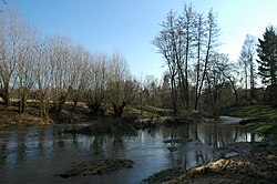
Schwabach (Regnitz)

Last updated

Schwabach
Schwabach Erlangen 02.jpg
Location
Country Germany
States Bavaria
Physical characteristics
Mouth  
  location
Regnitz
  coordinates
49°36′31″N10°59′51″E / 49.6086°N 10.9975°E / 49.6086; 10.9975 Coordinates: 49°36′31″N10°59′51″E / 49.6086°N 10.9975°E / 49.6086; 10.9975
Length32.4 km (20.1 mi) [1]
Basin size191 km2 (74 sq mi) [1]
Basin features
Progression RegnitzMainRhineNorth Sea

Schwabach is a river of Bavaria, Germany. It is a right tributary of the Regnitz in Erlangen.

Bavaria State in Germany

Bavaria, officially the Free State of Bavaria, is a landlocked federal state of Germany, occupying its southeastern corner. With an area of 70,550.19 square kilometres, Bavaria is the largest German state by land area comprising roughly a fifth of the total land area of Germany. With 13 million inhabitants, it is Germany's second-most-populous state after North Rhine-Westphalia. Bavaria's main cities are Munich, Nuremberg and Augsburg.

Germany Federal parliamentary republic in central-western Europe

Germany, officially the Federal Republic of Germany, is a country in Central and Western Europe, lying between the Baltic and North Seas to the north and the Alps, Lake Constance and the High Rhine to the south. It borders Denmark to the north, Poland and the Czech Republic to the east, Austria and Switzerland to the south, France to the southwest, and Luxembourg, Belgium and the Netherlands to the west.

Regnitz river in Germany

The Regnitz is a river in Franconia, Germany. It is a left tributary of the Main and is 63.7 km (39.6 mi) in length.

See also

Related Research Articles

House of Wittelsbach German noble family

The House of Wittelsbach is a European royal family and a German dynasty from Bavaria.

Swabia (Bavaria) Regierungsbezirk in Bavaria, Germany

Swabia is one of the seven administrative regions of Bavaria, Germany.

Bavarian language Major group of Upper German varieties spoken in the southeast of the German language area Bavaria

Bavarian is a West Germanic language belonging to the Upper German group, spoken in the southeast of the German language area, much of Bavaria, most of Austria and South Tyrol in Italy, as well as Samnaun in Switzerland. Before 1945, Bavarian was also prevalent in parts of the southern Czech Republic and western Hungary. It forms a continuum of more or less mutually intelligible local and regional variants.

Upper Bavaria Regierungsbezirk in Bavaria, Germany

Upper Bavaria is one of the seven administrative districts of Bavaria, Germany.

Lower Bavaria Regierungsbezirk in Bavaria, Germany

Lower Bavaria is one of the seven administrative regions of Bavaria, Germany, located in the east of the state.

Upper Palatinate Regierungsbezirk in Bavaria, Germany

The Upper Palatinate is one of the seven administrative districts of Bavaria, Germany, located in the east of Bavaria.

Iller river in Germany


The Iller  is a river of Bavaria and Baden-Württemberg in Germany. It is a right tributary of the Danube, 146 kilometres (91 mi) long.

The Regen is a river in Bavaria, Germany, and a left tributary of the Danube, at Regensburg, Germany. The source of its main headstream, the Great Regen, is in the Bohemian Forest on the territory of the Czech Republic, near Železná Ruda. The river crosses the border after a few kilometres, at Bayerisch Eisenstein. The name in German evolved from the name in Latin, but its meaning is unknown. The Romans called the river variously Regana, Reganus (masculine), and Reganum (neuter).

Freyung-Grafenau is a Landkreis (district) in Bavaria, Germany. It is bounded by the districts of Passau, Deggendorf and Regen, the Czech Republic and by Austria.

Bavarian Alps part of the Alps mountain range in Bavaria, Germany

Bavarian Alps is a summarizing term of several mountain ranges of the Northern Limestone Alps in the German state of Bavaria.

Bavarians people of Bavaria

Bavarians are a ethnographic group of Germans of the Bavaria region, a state within Germany. The group's dialect or speech is known as the Bavarian language, native to Altbayern, roughly the territory of the Electorate of Bavaria in the 17th century.

Central Bavarian dialect

Central Bavarian, also known as Central Austro-Bavarian, form a subgroup of Bavarian dialects in large parts of Austria and the German state of Bavaria along the Danube river, on the northern side of the Eastern Alps. They are spoken in the 'Old Bavarian' regions of Upper Bavaria, Lower Bavaria and in the adjacent parts of the Upper Palatinate region around Regensburg, in Upper and Lower Austria, in Vienna, in the state of Salzburg, as well as in the northern and eastern parts of Styria and Burgenland.

Duchy of Bavaria Former duchy in Germany

The Duchy of Bavaria was a frontier region in the southeastern part of the Merovingian kingdom from the sixth through the eighth century. It was settled by Bavarian tribes and ruled by dukes (duces) under Frankish overlordship. A new duchy was created from this area during the decline of the Carolingian Empire in the late ninth century. It became one of the stem duchies of the East Frankish realm which evolved as the Kingdom of Germany and the Holy Roman Empire.

Tauber river in Germany

The Tauber  is a river in Franconia, Germany. It is a left tributary of the Main and is 132 km (82 mi) in length. The name derives from the Celtic word for water.

Innviertel geographic region

The Innviertel is a traditional Austrian region southeast of the Inn river. It forms the western part of the state of Upper Austria and borders the German state of Bavaria. The Innviertel is one of the four traditional "quarters" of Upper Austria, the others being Hausruckviertel, Mühlviertel, and Traunviertel.

Kingdom of Bavaria kingdom in Central Europe between 1806–1918, from January 1871 part of the German Empire

The Kingdom of Bavaria was a German state that succeeded the former Electorate of Bavaria in 1805 and continued to exist until 1918. The Bavarian Elector Maximilian IV Joseph of the House of Wittelsbach became the first King of Bavaria in 1805 as Maximilian I Joseph. The crown would go on being held by the Wittelsbachs until the kingdom came to an end in 1918. Most of Bavaria's present-day borders were established after 1814 with the Treaty of Paris, in which Bavaria ceded Tyrol and Vorarlberg to the Austrian Empire while receiving Aschaffenburg and Würzburg. With the unification of Germany into the German Empire in 1871, the kingdom became a federal state of the new Empire and was second in size, power, and wealth only to the leading state, the Kingdom of Prussia. In 1918, Bavaria became a republic, and the kingdom was thus succeeded by the current Free State of Bavaria.

Southern Germany as a region has no exact boundary but is generally taken to include the areas in which Upper German dialects are spoken. That corresponds roughly to the historical stem duchies of Bavaria and Swabia or, in a modern context, to Bavaria and Baden-Württemberg within the Federal Republic of Germany, to the exclusion of the areas of the modern states of Austria and Switzerland. The Saarland and the southern parts of Hesse and Rhineland-Palatinate are sometimes included as well and correspond to the historical Franconia.

Bavarian State Police state police of Bavaria, Germany

The Bavarian State Police is the state police force of the German state of Bavaria. It has approximately 33,500 armed officers and roughly 8,500 other civilian employees. The police force is well-known for coordinated and consistent actions against even minor crimes.

Zusam river in Germany

The Zusam is a river in Bavaria, Germany and a right tributary of the Danube. Its source is just north of the village of Könghausen, in the Unterallgäu district of Bavaria. It flows north for approximately 97 km, before converging into the Danube near the town of Donauwörth.

References

  1. 1 2 Complete table of the Bavarian Waterbody Register by the Bavarian State Office for the Environment (xls, 10.3 MB)