
Doune Castle is a medieval stronghold near the village of Doune, in the Stirling district of central Scotland. The castle is sited on a wooded bend where the Ardoch Burn flows into the River Teith. It lies 8 miles (13 km) north-west of Stirling, where the Teith flows into the River Forth. Upstream, 8 miles (13 km) further north-west, the town of Callander lies at the edge of the Trossachs, on the fringe of the Scottish Highlands.

Moray is a county constituency of the House of Commons of the Parliament of the United Kingdom. It elects one Member of Parliament (MP) by the first past the post system of election.

Tibbers Castle is a motte-and-bailey castle overlooking a ford across the River Nith in Dumfries and Galloway, Scotland. To the east is the village of Carronbridge and to the north west is a 16th-century country house, Drumlanrig Castle.
The Breachacha crannog is a crannog located near Loch Breachacha, on the Inner Hebridean island of Coll. The crannog is recognised in the United Kingdom as a Scheduled monument. A scheduled monument is a 'nationally important' archaeological site or historic building, given legal protection against unauthorised change. There are about 8,000 such sites in Scotland.
Muiryfold was one of the Roman fortifications built by Septimius Severus in northern Caledonia. The site is located 6 kilometres (3.7 mi) east of Keith in Moray.
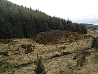
Wormy hillock henge is a small henge in Aberdeenshire, Scotland. It is a Scheduled Ancient Monument located in the Clashindarroch Forest. It is a low, circular bank 16.5 metres (54 ft) in diameter which almost surrounds a 6-metre (20 ft) wide platform in the centre. There is one gap in the bank at the southeast end of the henge.

Benie Hoose, also Bunyie Hoose, is a Neolithic site in the parish of Nesting, northeastern Whalsay, in the Shetland Islands of Scotland. It is located approximately 100 yards (91 m) to the northwest of the Standing Stones of Yoxie, and about 140 metres (460 ft) southeast of the Pettigarths Field Cairns. Benie Hoose and Yoxie demonstrate characteristics of 'paired houses'. It was excavated in 1954–1955 by Charles S. T. Calder who gave the items to the National Museum of Antiquities of Scotland in 1955–1956. Furthermore, its close proximity to Yoxie indicates that Druid priests probably lived in the house and performed ceremonies at the stones. OS (NKB) visited the site on 30 May 1968. The one-room site measures 24.4 by 12.8 metres, and features a horned forecourt.
The Pettigarths Field Cairns is a Neolithic site in the parish of Nesting, northeastern Whalsay, in the Shetland islands of Scotland. It is located approximately 140 metres (460 ft) to the northwest of Benie Hoose. The site contains upright stones as well as masonry. The south cairn is roughly 6 metres (20 ft) square, with an eastern entrance passage and circular chamber about 2 metres across. 4 metres (13 ft) to the north is a round cairn, 4.5 metres (15 ft) in diameter, with a rectangular cist. The two cairns are located on a rise, about 140 metres (460 ft) northwest of Benie Hoose.

Burghead Fort was a Pictish promontory fort on the site now occupied by the small town of Burghead in Moray, Scotland. It was one of the earliest power centres of the Picts and was three times the size of any other enclosed site in Early Medieval Scotland. The fort was probably the main centre of the Pictish Kingdom of Fortriu, flourishing like the kingdom itself from the 4th to the 9th centuries.
Thomshill, located 6 kilometres (3.7 mi) south of Elgin in Moray, Scotland, is the site of an excavated rectilinear enclosure that has been interpreted as a possible Roman military camp or fort. The enclosure covers an area of approximately 3.25 hectares and is situated at a height of 72 metres (236 ft) above ordnance datum.
Balnageith, located on the western edge of the suburbs of Forres in Moray, Scotland, is the site of an excavated linear cropmark with a rounded corner that has been interpreted as a possible Roman military camp or fort. The enclosure may originally have been of up to 2.4 hectares in size.

Durno or Logie Durno, located 6 miles (9.7 km) north west of Inverurie in Aberdeenshire, Scotland, is the site of a Roman marching camp, first discovered by aerial photography in July 1975 and excavated in 1976 and 1977.
Burnfield, located on the banks of the River Deveron in Aberdeenshire, Scotland, near Milltown of Rothiemay, is the site of a probable Roman marching camp, first discovered by aerial photography in 1982.
Bellie is a locality in Moray, Scotland. Located 2 miles north of Fochabers, Bellie is the site of a graveyard and of up to two possible Roman camps. Either of these sites, if accepted as a Roman camp, would constitute the most northerly example known, being 10 miles north west of the known camps at Auchinhove and Muiryfold.
Green Castle is a naturally defended rocky outcrop in the village of Portknockie in Moray, Scotland, that was occupied successively by small promontory forts of the Iron Age and Pictish periods.
The Doune of Relugas is a hill fort located 9.25 kilometres (5.75 mi) south south west of Forres in Moray, Scotland. It is situated on a rocky knoll rising to approximately 400 feet (120 m) above ordnance datum and forming the south east part of the promontory at the confluence of the River Findhorn and the River Divie. The site commands an uninterrupted view of the valley of the Findhorn as far as Culbin Sands, 9 miles to the north on the shore of the Moray Firth.

Dun Evan or the Doune of Cawdor is a hill fort located 2.5 kilometres (1.6 mi) south west of Cawdor in the Highland area of Scotland. It is situated on a rocky hill that rises to 678 feet (207 m) above ordnance datum between the valleys of the River Nairn and its tributary the Allt Dearg. The site has a wide view in all directions, extending to the mouth of the River Nairn at the town of Nairn, 7 miles to the north east on the shore of the Moray Firth. Dun Evan is scheduled by Historic Scotland as a site of national importance.
The Knock of Alves is a small wooded hill that lies 3 miles (4.8 km) to the west of Elgin in Moray, Scotland, and rises to 335 feet (102 m) above ordnance datum. Its summit is today marked by York Tower – a 3-storey octagonal folly erected in 1827 to commemorate Prince Frederick, the Duke of York; and the Forteath Mausoleum – built in 1850 as the burial place of 7 members of the Forteath family of the nearby house of Newton.

The Bulwarks, Porthkerry is a promontory fort in Rhoose, Vale of Glamorgan, on the southern coast of Wales overlooking the Bristol Channel. It probably dates to the Iron Age and continued to be occupied during the Roman period in Britain. The ramparts and ditches along the west side are well preserved, but the fortifications are heavily overgrown.
Cullen Castle was a royal castle about 0.5 miles (0.80 km) east of Cullen, Moray, Scotland, west of the burn of Deskford, and south of Seatown.


