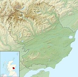
Angus is one of the 32 local government council areas of Scotland, a registration county and a lieutenancy area. The council area borders Aberdeenshire, Dundee City and Perth and Kinross. Main industries include agriculture and fishing. Global pharmaceuticals company GSK has a significant presence in Montrose in the north of the county.

The Loch Ness Monster, affectionately known as Nessie, is a creature in Scottish folklore that is said to inhabit Loch Ness in the Scottish Highlands. It is often described as large, long-necked, and with one or more humps protruding from the water. Popular interest and belief in the creature has varied since it was brought to worldwide attention in 1933. Evidence of its existence is anecdotal with a number of disputed photographs and sonar readings.

Loch is the Irish, Scottish Gaelic and Scots word for a lake or sea inlet. It is cognate with the Manx lough, Cornish logh, and one of the Welsh words for lake, llwch.

The River Tay is the longest river in Scotland and the seventh-longest in Great Britain. The Tay originates in western Scotland on the slopes of Ben Lui, then flows easterly across the Highlands, through Loch Dochart, Loch Iubhair and Loch Tay, then continues east through Strathtay, in the centre of Scotland, then southeasterly through Perth, where it becomes tidal, to its mouth at the Firth of Tay, south of Dundee. It is the largest river in the United Kingdom by measured discharge. Its catchment is approximately 2,000 square miles, the Tweed's is 1,500 sq mi (3,900 km2) and the Spey's is 1,097 sq mi (2,840 km2).
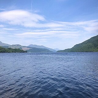
Loch Lomond is a freshwater Scottish loch which crosses the Highland Boundary Fault, often considered the boundary between the lowlands of Central Scotland and the Highlands. Traditionally forming part of the boundary between the counties of Stirlingshire and Dunbartonshire, Loch Lomond is split between the council areas of Stirling, Argyll and Bute and West Dunbartonshire. Its southern shores are about 23 kilometres (14 mi) northwest of the centre of Glasgow, Scotland's largest city. The Loch forms part of the Loch Lomond and The Trossachs National Park which was established in 2002.

Caledonian MacBrayne, usually shortened to CalMac, is the major operator of passenger and vehicle ferries, and ferry services, between the mainland of Scotland and 22 of the major islands on Scotland's west coast. Since 2006, the company's official name has been CalMac Ferries Ltd, although it still operates as Caledonian MacBrayne. In 2006, it became a subsidiary of holding company David MacBrayne, which is owned by the Scottish Government.

Loch Maree is a loch in Wester Ross in the Northwest Highlands of Scotland. At 21.7 km (13.46 mi) long and with a maximum width of four kilometres, it is the fourth-largest freshwater loch in Scotland; it is the largest north of Loch Ness. Its surface area is 28.7 km2 (11.08 sq mi).

Loch Lomond and The Trossachs National Park is a national park in Scotland centred on Loch Lomond and the hills and glens of the Trossachs, along with several other ranges of hills. It was the first of the two national parks established by the Scottish Parliament in 2002, the second being the Cairngorms National Park. The park extends to cover much of the western part of the southern highlands, lying to the north of the Glasgow conurbation, and contains many mountains and lochs. It is the fourth-largest national park in the British Isles, with a total area of 1,865 km2 (720 sq mi) and a boundary of some 350 km (220 mi) in length. It features 21 Munros and 20 Corbetts.

Loch Shiel is a freshwater loch situated 20 kilometres (12 mi) west of Fort William in the Highland council area of Scotland. At 28 kilometres long it is the 4th longest loch in Scotland, and is the longest to have retained a natural outflow without any regulation of its water level, being 120 m (393 ft) deep. Its nature changes considerably along its length, being deep and enclosed by mountains in the north east and shallow surrounded by bog and rough pasture in the south west, from which end the 4 km River Shiel drains to the sea in Loch Moidart near Castle Tioram.

Wester Ross is an area of the Northwest Highlands of Scotland in the council area of Highland. The area is loosely defined, and has never been used as a formal administrative region in its own right, but is generally regarded as lying to the west of the main watershed of Ross, thus forming the western half of the county of Ross and Cromarty. The southwesternmost part of Ross and Cromarty, Lochalsh, is not considered part of Wester Ross by the local tourist organisation, Visit Wester Ross, but is included within the definition used for the Wester Ross Biosphere Reserve.

Loch Tummel is a long, narrow loch, seven kilometres northwest of Pitlochry in the council area of Perth and Kinross, Scotland. It is fed and drained by the River Tummel, which flows into the River Tay about 13 km (8 mi) south-east of the Clunie Dam at the loch's eastern end.
Glen Strathfarrar is a glen in the Highland region of Scotland, near Loch Ness.
Eilean Chaluim Chille is an unpopulated island in the Outer Hebrides.
Loch Ròg or Loch Roag is a large sea loch on the west coast of Lewis, Outer Hebrides. It is broadly divided into East Loch Roag and West Loch Roag with other branches which include Little Loch Roag. The loch is dominated by the only inhabited island Great Bernera and East Loch Roag is actually referred to as Loch Bernera on early maps, most notably Murdoch MacKenzie's original Admiralty Chart from 1776. The use of west and east to differentiate the sections of the loch appear from the original Ordnance Survey in the 19th century.

Loch Creran is a sea loch in Argyll, on the west coast of Scotland. It is about 10 kilometres (6.2 mi) long from its head at Invercreran to its mouth on the Lynn of Lorne, part of Loch Linnhe. The loch separates the areas of Benderloch to the south and Appin to the north. The island of Eriska lies at the mouth of the loch. The loch is bridged at its narrowest point at Creagan, by the A828 road. The village of Barcaldine lies on the south shore of the loch.

Loch Alsh is a sea inlet between the isle of Skye in the Inner Hebrides and the Northwest Highlands of Scotland. The name is also used to describe the surrounding country and the feudal holdings around the loch. The area is rich in history, and is increasingly popular with tourists.

Loch Ness is a large freshwater loch in the Scottish Highlands extending for approximately 37 kilometres southwest of Inverness. It takes its name from the River Ness, which flows from the northern end. Loch Ness is best known for claimed sightings of the cryptozoological Loch Ness Monster, also known affectionately as "Nessie". It is one of a series of interconnected, murky bodies of water in Scotland; its water visibility is exceptionally low due to the high peat content of the surrounding soil. The southern end connects to Loch Oich by the River Oich and a section of the Caledonian Canal. The northern end connects to Loch Dochfour via the River Ness, which then ultimately leads to the North Sea via the Moray Firth.

Lewis and Harris, or Lewis with Harris, is a single Scottish island in the Outer Hebrides, divided by mountains. It is the largest island in Scotland and the third largest in the British Isles, after Great Britain and the island of Ireland, with an area of 841 square miles (2,178 km2), which is approximately 1% of the area of Great Britain. The northern two-thirds is called [the Isle of] Lewis and the southern third [the Isle of] Harris; each is referred to as if it were a separate island and there are many cultural and linguistic differences between the two.

Loch of Forfar is a freshwater loch lying on the western side of the town of Forfar, Scotland. The loch trends in an east to west direction and is approximately 1 mi (1.6 km) in length. The loch and area around it form Forfar Loch Country Park.