Related Research Articles

Webster County is a county located in the west central portion of the U.S. state of Georgia. As of the 2020 census reflected a population of 2,348, making it the third-least populous county in Georgia. The county seat is Preston.

Chattahoochee County, also known as Cusseta-Chattahoochee County, is a county located on the western border in central Georgia. As of the 2020 census, the population was 9,565. The county seat is Cusseta, with which the county shares a consolidated city-county government. The city of Cusseta remains a geographically distinct municipality within Chattahoochee County. The county was created on February 13, 1854.

Cusseta is a city in Chattahoochee County, Georgia, United States. It is part of the Columbus, Georgia-Alabama metropolitan statistical area. The population was 9,565 in 2020. The city is the county seat of Chattahoochee County, with which it shares a consolidated city-county government. Despite this, Cusseta is not coterminous with the county; it remains a geographically distinct municipality within the county.

Tyrone is a town in Fayette County, Georgia, United States. The population was 7,658 in 2020. The estimated population in 2018 was 7,388. It is a part of the Atlanta metropolitan area.

Hampton is a city in southwestern Henry County, Georgia, United States. The population as of the 2020 census was 8,368. It is a southeastern suburb in the Atlanta metropolitan area.

Ideal is a city in Macon County, Georgia, United States. The population was 407 at the 2020 census, down from 499 in 2010.

Greenville is a city and the county seat of Meriwether County, Georgia, United States. The population was 794 at the 2020 census, down from 876 in 2010. The city is located 60 miles (97 km) southwest of Atlanta and is part of the Atlanta metropolitan area.
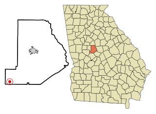
Culloden is a city in Monroe County, Georgia, United States. The population was 200 in the 2020 census. It is part of the Macon metropolitan statistical area.

Higgston is a town in Montgomery County, Georgia, United States. The population was 314 at the 2020 census.
Butler is the county seat of Taylor County, Georgia, United States. Its population was 1,972 at the 2010 census, and 1,881 in 2020.

Pine River Township is a civil township of Gratiot County in the U.S. state of Michigan. The population was 2,348 at the 2020 census.
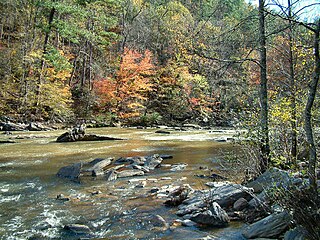
Sweetwater Creek is a 45.6-mile-long (73.4 km) stream in the U.S. state of Georgia, west of Atlanta. It begins in southwestern Paulding County, flowing generally eastward into southwestern Cobb County, then turning south into eastern Douglas County. It is a tributary of the Chattahoochee River, and near its end it is the centerpiece of Sweetwater Creek State Park.
Muckalee Creek is a creek in southwest Georgia. It originates southeast of Buena Vista and flows south-southeast for 76.3 miles (122.8 km) and into Kinchafoonee Creek north of Albany, just upstream of that creek's confluence with the Flint River.
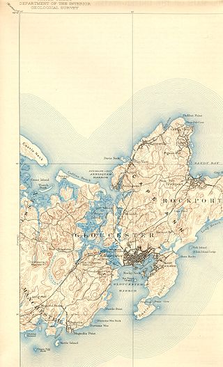
The Annisquam River is a tidal, salt-water estuary in the Annisquam neighborhood of Gloucester, Massachusetts, connecting Annisquam Harbor on the north to Gloucester Harbor on the south. The segment between Gloucester Harbor and the Newburyport/Rockport Line bridge is also known as the Blynman Canal.
Rocky Comfort Creek is a 62.4-mile-long (100.4 km) tributary of the Ogeechee River in the U.S. state of Georgia. Rising in Warren County 9 miles (14 km) northwest of Warrenton, it flows southeast, entering Glascock County and passing the town of Gibson, then continuing south into Jefferson County, where it reaches the Ogeechee River at Louisville.
Upatoi Creek is a 35.5-mile-long (57.1 km) river in western Georgia, just outside Columbus. It runs from Upatoi, through South Columbus, and to the Chattahoochee River.
Coleoatchee Creek is a creek in Talbot County, Georgia. It rises at the base of Pine Mountain Range near the Meriwether County/Talbot County border. The creek has a very strong source, which continues to flow strongly in the severest droughts. The creek generally flows south through prime agricultural land to its junction with Big Lazer Creek south of Georgia Highway 36.
Angelica Creek is a stream in the U.S. state of Georgia.
Mossy Creek is an unincorporated community in White County, in the state of Georgia in the United States of America.
Tobler Creek is a stream in the U.S. state of Georgia. It is a tributary to the Ocmulgee River.
References
- 1 2 U.S. Geological Survey Geographic Names Information System: Auchumpkee Creek
- ↑ Krakow, Kenneth K. (1975). Georgia Place-Names: Their History and Origins (PDF). Macon, GA: Winship Press. p. 9. ISBN 0-915430-00-2.
- ↑ Bright, William (2004). Native American Placenames of the United States. University of Oklahoma Press. p. 55. ISBN 978-0-8061-3598-4.
32°41′08″N84°11′50″W / 32.68556°N 84.19722°W