The Sauerland[ˈzaʊɐlant] is a rural, hilly area spreading across most of the south-eastern part of North Rhine-Westphalia, in parts heavily forested and, apart from the major valleys, sparsely inhabited. For these reasons, it has been chosen as the first place in Germany to reintroduce the Wisent.

The Ebbe Mountains or Ebbe form a range of uplands up to 663.3 m above sea level (NN) high in the German state of North Rhine-Westphalia. They have given their name to the Ebbe Mountain Nature Park and are part of the Süder Uplands within the Rhine Massif.

The Lenne Mountains, or Lenne Uplands (Lennebergland), is a range of hills up to 656 m above sea level (NN) high in the German state of North Rhine-Westphalia. It is part of the Süder Uplands within the Rhine Massif.

The Saalhausen Hills are a range of hills up to 687.7 m above sea level (NN) high in the Sauerland region within the districts of Olpe and Hochsauerlandkreis in the German state of North Rhine-Westphalia. They are part of the Rhine Massif and lie within the Süder Uplands.

The Gladenbach Uplands, named after their central town of Gladenbach, is a range of hills up to 609 m high in the Rhine Massif in Germany, on the junction of the Rothaar Mountains, Westerwald (southwest), (Eastern) Hintertaunus and West Hesse Highlands in the east. It lies in Central Hesse within the districts of Marburg-Biedenkopf, Lahn-Dill and Gießen within the so-called Lahn-Dill-(Dietzhölze-) loop. Small parts of the Upper Lahn Valley in the northwest belong, together with the town of Bad Laasphe, also to the district of Siegen-Wittgenstein, North Rhine-Westphalia.
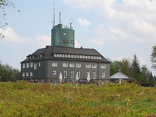
The Kahler Asten is an 841.9-metre-high mountain in the Rothaar range in the district of Hochsauerland, in the German state of North Rhine-Westphalia. It is a popular destination, receiving more than 500,000 visitors annually.

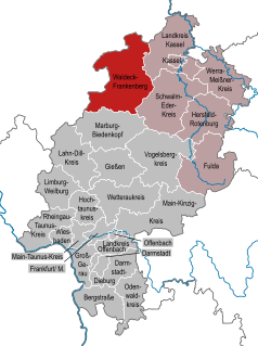
The Upland, which is Low German for something like Oberland ("highland") or auf dem Land, is a low mountain region forming the northeastern part of the High Sauerland and belongs the German state of Hesse, unlike the remainder of the High Sauerland which lies in Westphalia. The Upland falls within the district of Waldeck-Frankenberg, in North Hesse and corresponds to the territory of the municipality of Willingen.

The Rothaarsteig is a 154.80 km long hiking trail along the crest of the Rothaargebirge mountain range in Germany in the border region between the states of North Rhine-Westphalia (NW) and Hesse (HE). It was opened in 2001.

The Ardey Hills are a range of wooded hills, up to 273.8 m above sea level (NN), in the territory of the city of Dortmund and the districts of Ennepe-Ruhr-Kreis and Unna in the German state of North Rhine-Westphalia. The hills form part of the eastern Rhenish Massif and, to a lesser extent, to the Berg-Mark Hills.
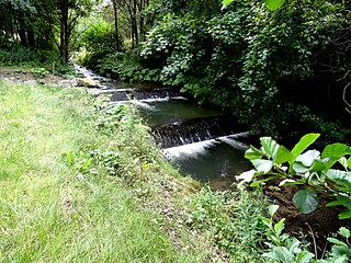
Hillebach is a small river of North Rhine-Westphalia, Germany. It flows into the Ruhr near Winterberg.

The Plackwald is a ridge of hills, up to 581.5 m above sea level (NHN), and part of the Rhenish Massif in the counties of Soest and Hochsauerlandkreis, North Rhine-Westphalia, Germany. Within the North Sauerland Highlands it forms the natural region sub-unit of Plackweghöhe (Plackwald) (334.5).
The Plackweghöhe, whose main summit has hitherto had no official name, is the highest point in the borough of Warstein, the hill ridge of the Plackwald, the North Sauerland Uplands, and the Arnsberg Forest Nature Park in the German state of North Rhine-Westphalia. It is 581.5 m above sea level (NHN) and lies within the counties of Soest and Hochsauerlandkreis. The Lörmecke Tower observation tower at the top is a popular destination.
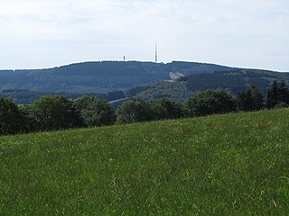
The Nordhelle between Reblin and Valbert in the county of Märkischer Kreis in the German state of North Rhine-Westphalia is the highest peak in the Ebbe Mountains and in Märkischer Kreise. At the summit is the Nordhelle Transmitter and a viewing tower, the Robert Kolb Tower.
The Hohe Egge near Ottlar in the North Hessian county of Waldeck-Frankenberg is a hill, 604.9 m above sea level (NHN), in the Upland in the Rothaar mountains.
The Brilon Plateau is a highland area in the county of Hochsauerlandkreis in the German state of North Rhine-Westphalia. It is surrounded by the Brilon Heights, whose mountains reach a height of 670.2 m above sea level (NHN).

The Trödelsteine is the name of a mountain, 613 m above sea level (NHN), in the Heller Upland near Emmerzhausen in the county of Altenkirchen in the German state of Rhineland-Palatinate and in the county of Siegen-Wittgenstein in the state of North Rhine-Westphalia with its summit area in Rhineland-Palatinate.