
Augusta, officially Augusta–Richmond County, is a consolidated city-county on the central eastern border of the U.S. state of Georgia. The city lies across the Savannah River from South Carolina at the head of its navigable portion. Georgia's second-largest city after Atlanta, Augusta is located in the Fall Line section of the state.
A special-purpose local-option sales tax (SPLOST) is a financing method for funding capital outlay projects in the U.S. state of Georgia. It is an optional 1% sales tax levied by any county for the purpose of funding the building of parks, schools, roads, and other public facilities. The revenue generated cannot be used towards operating expenses or most maintenance projects.
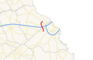
Interstate 520 (I-520) is a 23.34-mile (37.56 km) auxiliary Interstate Highway that encircles most of Augusta, Georgia, and North Augusta, South Carolina, as a three-quarter beltway around the western, southern, and eastern parts of the main part of the Augusta metropolitan area. It begins at I-20 and State Route 232 (SR 232) in the northern part of Augusta, and ends at I-20 in the northern part of North Augusta, South Carolina. I-520 is also known as Bobby Jones Expressway and the Deputy James D. Paugh Memorial Highway in Georgia and Palmetto Parkway in South Carolina. On the Georgia side, the road also carries the internal designation State Route 415.

The Augusta Canal is a historic canal located in Augusta, Georgia, United States. The canal is fed by the Savannah River and passes through three levels in suburban and urban Augusta before the water returns to the river at various locations. It was devised to harness the water power at the fall line of the Savannah River to drive mills, to provide transportation of goods, and to provide a municipal water supply. It is the only canal in the US in continuous use for its original purposes of providing power, transport, and municipal water.

The Butt Memorial Bridge is a road bridge in Augusta, Georgia that carries 15th Street over the Augusta Canal. It is dedicated to Major Archibald Willingham Butt, born in Augusta and a victim of the sinking of RMS Titanic. The bridge was erected in 1914 and dedicated by President William Howard Taft, a personal friend of Butt's. It is notable that the bridge was the first memorial erected to remember the Titanic disaster, and it stands today as the only memorial in Georgia dedicated to the disaster. The bridge is made of stone, featuring four pillars topped with bronze-banded globes placed over electric lights. Four lions with plaques adorn each side and end of the bridge, while lights are strung from one end of the bridge to the other. A memorial plaque is located on the center of the bridge, dedicated to Butt's memory.

State Route 10 (SR 10) is a 172.3-mile-long (277.3 km) state highway in the U.S. state of Georgia. It travels from Downtown Atlanta to the South Carolina state line in Augusta. This highway, along with U.S. Route 78 (US 78), connect three of the biggest metro areas of the state together: Atlanta, Athens, and Augusta. It travels concurrently with US 78 in three sections: from Atlanta to Druid Hills; from near Stone Mountain to near Athens; and from Athens to its eastern terminus, for a total of 149.2 miles (240.1 km), or approximately 86.6 percent of its route.
The Fall Line Freeway is a 215-mile-long (346 km) highway designed to span the width of the U.S. state of Georgia from Columbus at the Alabama state line to Augusta, traveling through several cities including Macon, Fort Valley, Sandersville, and Wrens. Though it is called a freeway, it is composed of both limited-access and high-speed divided highway portions. There are also two segments of the highway that are two lanes, separated by a center turn lane: a brief portion in west-central Washington County and another brief portion in northern Jefferson County. As of August 2018, the Fall Line Freeway is 100% open to traffic. Between August 2017 and July 2018, the highway was completed. The Georgia Department of Transportation (GDOT) announced that the highway was officially signed as SR 540 on September 24, 2018.
U.S. Route 1 (US 1) in the U.S. state of Georgia, which is concurrent for almost its entire length with State Route 4 (SR 4), is a highway traversing south-to-north through portions of Charlton, Ware, Bacon, Appling, Toombs, Emanuel, Jefferson, and Richmond counties in the southeastern and east-central parts of the state. In Georgia, the highway originates at US 1/US 23/US 301/SR 15 at the St. Marys River and the Florida state line, where SR 4 and SR 15 reach their southern terminus. It travels to its northern terminus at US 1/US 25/US 78/US 278/SC 121 at the Savannah River and the South Carolina state line in Augusta. Here, SR 10 reaches its eastern terminus, and SR 121 reaches its northern terminus.

State Route 4 (SR 4) is a state highway in the eastern part of the U.S. state of Georgia. Except for its northernmost portion, it is completely concurrent for its entire length with U.S. Route 1 (US 1). It traverses south-to-north through portions of Charlton, Ware, Bacon, Appling, Toombs, Emanuel, Jefferson, and Richmond counties in the southeastern and east-central parts of the state. The highway begins at the Florida state line, on US 1/US 23/US 301/SR 15 at the St. Marys River, where SR 15 also reaches its southern terminus. It travels to its northern terminus at the South Carolina state line, on the Augusta–North Augusta, South Carolina city line, on US 25 Business at the Savannah River.
State Route 383 (SR 383) is a 7.4-mile-long (11.9 km) state highway in the east-central part of the U.S. state of Georgia. It is located within portions of Richmond and Columbia counties. It connects Fort Gordon with Martinez and Evans.
State Route 28 (SR 28) is a 25.7-mile-long (41.4 km) state highway in the U.S. state of Georgia. It exists in two distinct segments separated by the northern segment of South Carolina Highway 28 (SC 28), which connects the two segments. The southern segment is entirely within the Augusta metropolitan area. The northern segment is located in the northeastern corner of the Chattooga River District of the Chattahoochee–Oconee National Forest. SR 28 consists of Georgia's segments of a multi-state Route 28 that includes two segments of SC 28 and one segment of North Carolina Highway 28 (NC 28). The northern segment of SR 28 is unnamed, but the southern segment is known as Furys Ferry Road from its western terminus to the intersection with SR 104 Conn. in Augusta, Washington Road in the northern part of Augusta, John C. Calhoun Expressway, Greene Street, 5th Street, and Broad Street in downtown Augusta, and Sand Bar Ferry Road in the northeastern part of Augusta.

State Route 21 (SR 21) is an 84.4-mile-long (135.8 km) state highway that travels southeast-to-northwest through portions of Chatham, Effingham, Screven, and Jenkins counties in the eastern part of the U.S. state of Georgia. The highway connects the Savannah and Millen areas, via Garden City, Port Wentworth, Rincon, Springfield, and Sylvania.

State Route 56 (SR 56) is a 140.3-mile-long (225.8 km) state highway that travels south-to-north in an upside down question mark, with a western loop around Vidalia. It travels through portions of Tattnall, Toombs, Montgomery, Treutlen, Emanuel, Burke, and Richmond counties in the southeastern and east-central parts of the U.S. state of Georgia. The route connects the Reidsville and Augusta areas, via Swainsboro and Waynesboro.

State Route 104 (SR 104) is a 22.3-mile-long (35.9 km) state highway in the east-central part of the U.S. state of Georgia. Most of its eastern portion is an urban corridor in the Augusta metropolitan area. It travels within portions of Columbia and Richmond counties. It is known as Washington Road from its western terminus to the Columbia–Richmond county line. On both sides of the county line, it is known as Pleasant Home Road. It is known as Riverwatch Parkway from just west of the county line to the northern part of downtown Augusta. In downtown, it is known as part of Jones Street and Reynolds Street.
U.S. Route 278 (US 278) in the U.S. state of Georgia is an east–west United States Highway traversing the north-central portion of the state. The highway travels from its western terminus as US 278/SR 74 at the Alabama state line near Esom Hill to its eastern terminus at US 1/US 25/US 78/US 278/SC 121 in the Augusta metropolitan area where it crosses the Savannah River into South Carolina.
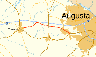
State Route 223 (SR 223) is a 20.9-mile-long (33.6 km) east–west state highway in the east-central part of the U.S. state of Georgia. Its routing travels through portions of McDuffie, Columbia, and Richmond counties. The highway connects Thomson with Grovetown, Augusta, and Fort Gordon. Except for the portions in Thomson, Grovetown, and Augusta, the highway is relatively rural.

Georgia State Route 121 (SR 121) is a 238-mile-long (383 km) state highway between Charlton County and Augusta. It is part of a three-state multistate route beginning in Florida and ending in South Carolina.
Several special routes of U.S. Route 25 exist. In order from south to north they are as follows.
The City of Augusta, Georgia has an expansive transport network. It consists of two airports, various road bridges, national and local bus service, a highway and street network, freight train service, and boat tours and marinas.
