Augustus Island (Western Australia)

Last updated

Augustus Island
(Wurroolgu)
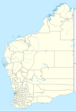
Australia Western Australia location map.svg
Red pog.svg
Augustus Island
(Wurroolgu)
Location of Augustus Island
Geography
Coordinates 15°21′41″S124°33′06″E / 15.3614°S 124.5516°E / -15.3614; 124.5516 Coordinates: 15°21′41″S124°33′06″E / 15.3614°S 124.5516°E / -15.3614; 124.5516
Total islands1
Area18,992 ha (46,930 acres)
Length22 km (13.7 mi) [lower-alpha 1]
Width16 km (9.9 mi) [lower-alpha 1]
Administration
State Western Australia
Region Kimberley
Shire Wyndham-East Kimberley
Demographics
Population0

Augustus Island (Worrorra: Wurroolgu), is an uninhabited island off the Kimberley coast of Western Australia, within the Shire of Wyndham-East Kimberley.

The island is 22 kilometres (14 mi) in length and has a maximum width of 16 kilometres (10 mi) [1] with a total area of 190 square kilometres (73 sq mi) [2] and has an irregular shape. It is at the Southern end of the Bonaparte Archipelago.

The island is found approximately 120 kilometres (75 mi) north-east of Bardi.

Although most of the islands in the Kimberley are unallocated DEC crown land, Jungulu is one of the islands near the former Kunmunya Mission which are included in Reserve 23079 for Use and Benefit of Aborigines .

The island is uninhabited and contains no known feral animals. [3]

Many flora and fauna were isolated from the mainland when sea levels rose and many populations are found intact on the island. The island provides ideal habitat for the Nabarlek, also known as the Little Rock-Wallaby, with the weathered sandstone forming deep fissures. [4]

The golden bandicoot is another vulnerable species that is resident on the island, the last recorded sighting being in 2003. This species favours the Warton sandstone and the heathland on dissected sandstone. [5]
Notes

  1. 1 2 The maximum measurement in this dimension.

Related Research Articles

<span class="mw-page-title-main">Geography of the Falkland Islands</span> Geography of the Falkland Islands

The Falkland Islands are located in the South Atlantic Ocean between 51°S and 53°S on a projection of the Patagonian Shelf, part of the South American continental shelf. In ancient geological time this shelf was part of Gondwana, and around 400 million years ago split from what is now Africa and drifted westwards from it. Today the islands are subjected to the Roaring Forties, winds that shape both their geography and climate.

The Pilbara is a large, dry, thinly populated region in the north of Western Australia. It is known for its Aboriginal peoples; its ancient landscapes; the red earth; and its vast mineral deposits, in particular iron ore. It is also a global biodiversity hotspot for subterranean fauna.

<span class="mw-page-title-main">Threatened fauna of Australia</span> Animals at risk of becoming extinct

Threatened fauna of Australia are those species and subspecies of birds, fish, frogs, insects, mammals, molluscs, crustaceans and reptiles to be found in Australia that are in danger of becoming extinct. This list is the list proclaimed under the Australian federal Environment Protection and Biodiversity Conservation Act 1999. The classifications are based on those used by the World Conservation Union (IUCN), however IUCN and Australian rankings do differ. Each state and territory has its own legislation relating to environmental protection.

<span class="mw-page-title-main">Barrow Island (Western Australia)</span> Island off the coast of Western Australia

Barrow Island is a 202-square-kilometre (78 sq mi) island 50 kilometres (31 mi) northwest off the Pilbara coast of Western Australia. The island is the second largest in Western Australia after Dirk Hartog Island.

<span class="mw-page-title-main">Buccaneer Archipelago</span> Archipelago of the Western Australian Kimberley coast

The Buccaneer Archipelago is a group of islands off the coast of Western Australia near the town of Derby in the Kimberley region. The closest inhabited place is Bardi located about 54 kilometres (34 mi) from the western end of the island group.

Marchinbar Island is the largest island in the Wessel Islands in the Northern Territory of Australia in the Arafura Sea.

<span class="mw-page-title-main">Golden bandicoot</span> Species of marsupial

The golden bandicoot is a short-nosed bandicoot found in northern Australia. It is the smallest of its genus.

<span class="mw-page-title-main">Islands of the Forth</span> Group of islands in the Firth of Forth, Scotland

The Islands of the Forth are a group of small islands located in the Firth of Forth and in the estuary of the River Forth on the east coast of Scotland. Most of the group lie in the open waters of the firth, between the Lothians and Fife, with the majority to the east of the city of Edinburgh. Two islands lie further west in the river estuary.

<span class="mw-page-title-main">Mitchell River National Park (Western Australia)</span> Protected area in Western Australia

Mitchell River National Park is a national park in the Kimberley region of Western Australia, 2,140 kilometres (1,330 mi) northeast of Perth. The park adjoins the northern boundary of the Prince Regent National Park. The nearest towns are Derby, 350 kilometres (217 mi) to the southwest, as well as Wyndham, 270 km (168 mi) to the southeast. Created in 2000, the park covers an area of over 1,150 km2 (440 sq mi) on the Mitchell Plateau (Ngauwudu).

The Bonaparte Archipelago is a group of islands off the coast of Western Australia in the Kimberley region, within the Shire of Wyndham-East Kimberley. The closest inhabited place is Kalumburu located about 100 kilometres (62 mi) to the east of the island group. The archipelago was named by the Baudin expedition on 16 August 1801 after Napoleon Bonaparte, First Consul of France.

Bigge Island is an island off the coast of the Kimberley region in Western Australia, within the Shire of Wyndham-East Kimberley.

<span class="mw-page-title-main">Prince Regent National Park</span> Protected area in Western Australia

Prince Regent National Park, formerly the Prince Regent Nature Reserve, is a protected area in the Kimberley region of Western Australia. In 1978 the area was nominated as a UNESCO World Biosphere Reserve.

Charnley River–Artesian Range Wildlife Sanctuary is a protected area covering about 3,000 square kilometres (1,200 sq mi) in the Kimberley region of Western Australia. It is situated about 205 kilometres (127 mi) east of Derby and 287 kilometres (178 mi) north west of Halls Creek, and is accessed via the Gibb River Road. It is named after the Charnley River that flows through the property.

Uwins Island is located off the Kimberley coast of Western Australia.

Hidden Island, known to the traditional owners as Banggoon, is an uninhabited island located in the Kimberley region of Western Australia.

Storr Island, also known as Yudawala or Yeewadan Ganjal, is an uninhabited island located in the Kimberley region of Western Australia.

Katers Island is an uninhabited island located in the Kimberley region of Western Australia.

Lachlan Island is an island off the Kimberley coast of Western Australia.

Wollaston Island is an island off the Kimberley coast of Western Australia.

References

  1. "Ocean Dots Encyclopedia - Augustus Island". 2009. Archived from the original on 23 December 2010. Retrieved 21 March 2009.
  2. "Bonzle Digital Atlas - Map of Augustus Island". 2009. Retrieved 21 March 2009.
  3. "North Kimberley" (PDF). 2001. Archived from the original (PDF) on 30 July 2008. Retrieved 21 March 2009.
  4. "Fact Sheet - Narbalek". 2007. Retrieved 21 March 2009.
  5. "Isoodon auratus auratus — Golden Bandicoot (mainland)". Department of Environment. 2009. Retrieved 21 March 2009.