
The Murray River is a river in Southeastern Australia. It is Australia's longest river at 2,508 km (1,558 mi) extent. Its tributaries include five of the next six longest rivers of Australia. Together with that of the Murray, the catchments of these rivers form the Murray–Darling basin, which covers about one-seventh the area of Australia. It is widely considered Australia's most important irrigated region.

The Great Dividing Range, also known as the East Australian Cordillera or the Eastern Highlands, is a cordillera system in eastern Australia consisting of an expansive collection of mountain ranges, plateaus and rolling hills, that runs roughly parallel to the east coast of Australia and forms the fifth-longest land-based mountain chain in the world, and the longest entirely within a single country. It is mainland Australia's most substantial topographic feature and serves as the definitive watershed for the river systems in eastern Australia, hence the name.

The Burke and Wills expedition was organised by the Royal Society of Victoria in Australia in 1860–61. It consisted of 19 men led by Robert O'Hara Burke and William John Wills. Its objective was the crossing Australia from Melbourne in the south to the Gulf of Carpentaria in the north, a distance of around 3,250 kilometres. At that time most of the inland of Australia had not been explored by non-Indigenous people and was largely unknown to the European settlers.

The Hume and Hovell expedition was a journey of exploration undertaken in eastern Australia. In 1824 the Governor of New South Wales, Sir Thomas Brisbane, commissioned Hamilton Hume and former Royal Navy Captain William Hovell to lead an expedition to find new grazing land in the south of the colony, and also to find an answer to the mystery of where New South Wales's western rivers flowed.

Charles Napier Sturt was a British officer and explorer of Australia, and part of the European exploration of Australia. He led several expeditions into the interior of the continent, starting from Sydney and later from Adelaide. His expeditions traced several of the westward-flowing rivers, establishing that they all merged into the Murray River, which flows into the Southern Ocean. He was searching to prove his own passionately held belief that an "inland sea" was located at the centre of the continent. He reached the rank of Captain, served in several appointed posts, and on the Legislative Council.

The Darling River is the third-longest river in Australia, measuring 1,472 kilometres (915 mi) from its source in northern New South Wales to its confluence with the Murray River at Wentworth, New South Wales. Including its longest contiguous tributaries it is 2,844 km (1,767 mi) long, making it the longest river system in Australia. The Darling River is the outback's most famous waterway.
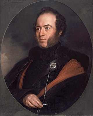
Sir Thomas Livingstone Mitchell, surveyor and explorer of Southeastern Australia, was born at Grangemouth in Stirlingshire, Scotland. In 1827 he took up an appointment as Assistant Surveyor General of New South Wales. The following year he became Surveyor General and remained in this position until his death. Mitchell was knighted in 1839 for his contribution to the surveying of Australia.
The Murray–Darling basin is a large geographical area in the interior of southeastern Australia, encompassing the drainage basin of the tributaries of the Murray River, Australia's longest river, and the Darling River, a right tributary of the Murray and Australia's third-longest river. The basin, which includes six of Australia's seven longest rivers and covers around one-seventh of the Australian landmass, is one of the country's most significant agricultural areas providing one-third of Australia's food supply. Located west of the Great Dividing Range, it drains southwestly into the Great Australian Bight and spans most of the states of New South Wales and Victoria, the Australian Capital Territory, and parts of the states of Queensland and South Australia.
Menindee is a small town in the far west of New South Wales, Australia, in Central Darling Shire, on the banks of the Darling River, with a sign-posted population of 980 and a 2016 census population of 551. Menindee was the first town to be established on the Darling River. There are two distinct theories for the derivation of the township’s name: (a) from the Barkindji word "minandichi" for the shallow ephemeral lake north-west of the present-day township; (b) from the Barkindji word 'milhthaka', meaning "yolk of an egg".

The Loddon River, an inland river of the north–central catchment, part of the Murray-Darling basin, is located in the lower Riverina bioregion and Central Highlands and Loddon Mallee regions of the Australian state of Victoria. The headwaters of the Loddon River rise on the northern slopes of the Great Dividing Range east of Daylesford and descend to flow north into the Little Murray River, near Swan Hill. The river is impounded by the Cairn Curran and Laanecoorie reservoirs. The Tullaroop Creek tributary, which joins just above Laanecoorie Reservoir, is impounded by the Tullaroop Reservoir (72,950ML).

The Castlereagh River is located in the central–western district of New South Wales, Australia. It is part of the Macquarie-Castlereagh catchment within the Murray–Darling basin and is an unregulated river, meaning no dams or storage have been built on it to control flows. On a map of NSW, the Castlereagh has a distinctive appearance among the north-western rivers for its fish-hook-like shape: from upstream in the north at its confluence with the Macquarie River it extends southwards to a hook-shape, flattened-out at the base, which curves to the right through to the tip of the hook in the Warrumbungle Mountains at the river's source.

Robert O'Hara Burke was an Irish soldier and police officer who achieved fame as an Australian explorer. He was the leader of the ill-fated Burke and Wills expedition, which was the first expedition to cross Australia from south to north, finding a route across the continent from the settled areas of Victoria to the Gulf of Carpentaria. The expedition party was well equipped, but Burke was not experienced in bushcraft. A Royal Commission report conducted upon the failure of the expedition was a censure of Burke's judgement.

William John Wills was a British surveyor who also trained as a surgeon. Wills achieved fame as the second-in-command of the ill-fated Burke and Wills expedition, which was the first expedition to cross Australia from south to north, finding a route across the continent from the settled areas of Victoria to the Gulf of Carpentaria.

William Landsborough was an explorer of Australia and notably he was the first explorer to complete a North-to-South crossing of Australia. He was a member of the Queensland Legislative Council.

The Nive River is a river that is part of the Darling catchment within the Murray–Darling basin, is located in the south west region of Queensland, Australia.

The Campaspe River, an inland intermittent river of the north–central catchment, part of the Murray-Darling basin, is located in the lower Riverina bioregion and Central Highlands and Wimmera regions of the Australian state of Victoria. The headwaters of the Campaspe River rise on the northern slopes of the Great Dividing Range and descend to flow north into the Murray River, Australia's longest river, near Echuca.

The Richardson River, an inland intermittent river of the Wimmera catchment, located in the Grampians and Wimmera regions of the Australian state of Victoria. Rising on the northern slopes of the Great Dividing Range, the Richardson River flows generally north and drains into Lake Buloke, one of a series of ephemeral lakes that, whilst they do not directly empty into a defined watercourse, form part of the Murray River catchment of the Murray-Darling basin.

European land exploration of Australia deals with the opening up of the interior of Australia to European settlement which occurred gradually throughout the colonial period, 1788–1900. A number of these explorers are very well known, such as Burke and Wills who are well known for their failed attempt to cross the interior of Australia, as well as Hamilton Hume and Charles Sturt.

The European exploration of Australia first began in February 1606, when Dutch navigator Willem Janszoon landed in Cape York Peninsula and on October that year when Spanish explorer Luís Vaz de Torres sailed through, and navigated, Torres Strait islands. Twenty-nine other Dutch navigators explored the western and southern coasts in the 17th century, and dubbed the continent New Holland.

James Larmer was a government surveyor in the colony of New South Wales. Between 1830 and 1859, he surveyed land, roads and settlements in New South Wales. He was an Assistant Surveyor to the Surveyor-General, Sir Thomas Mitchell, from 1835 to 1855. In 1835, he was second in command of Mitchell’s second expedition. He is also noteworthy for his recording of Aboriginal words from various parts of New South Wales.