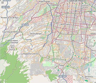
The Autopista Chamapa–La Venta is a toll road in Greater Mexico City. It, together with the Autopista Chamapa-Lechería is a single through route serving as a partial ring road (beltway) on the west side of the megalopolis. It connects:

Greater Mexico City refers to the conurbation around Mexico City, officially called Valley of Mexico Metropolitan Area, constituted by Mexico City itself composed of 16 Municipalities—and 41 adjacent municipalities of the states of Mexico and Hidalgo. For normative purposes, however, Greater Mexico City most commonly refers to the Metropolitan Area of the Valley of Mexico an agglomeration that incorporates 18 additional municipalities. As of 2016 an estimated 21,157,000 people lived in Greater Mexico City, making it the largest metropolitan area in North America. It is surrounded by thin strips of highlands which separate it from other adjacent metropolitan areas, of which the biggest are Puebla, Toluca, and Cuernavaca-Cuautla, and together with which it makes up the Mexico City megalopolis.

A ring road is a road or a series of connected roads encircling a town, city, or country. The most common purpose of a ring road is to assist in reducing traffic volumes in the urban centre, such as by offering an alternate route around the city for drivers who do not need to stop in the city core.
- the northern edge of the metropolitan area at Cuautitlán at the junction with the Mexico City-Querétaro and Circuito Exterior Mexiquense toll roads at Lechería, and runs 27 km to Chamapa
- from which the 14.2 kilometres (8.8 mi) Autopista Chamapa–La Venta continues to the western edge of the metro area at La Venta, west of the major business district of Santa Fe

Cuautitlán is a city and municipality in the State of Mexico, just north of the northern tip of the Federal District within the Greater Mexico City urban area. The city has engulfed most of the municipality, making the two synonymous. The name comes from Nahuatl and means 'between the trees.'

The Circuito Exterior Mexiquense literally, "Outer Loop of the State of Mexico", also known as the Vía Mexiquense or "'Autopista mexiquense'" is a series of toll roads constructed between 2006 and 2011 by the State of Mexico government, providing an option for motorists to skirt the edge of Greater Mexico City when driving between areas in the State of Mexico to the northwest of Mexico City, northeast of Mexico City and east of Mexico City. Portions carry the Mexican Federal Highway 57D designation, and others carry the State of Mexico State Highway 5D designation.
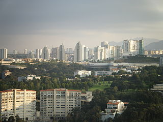
Santa Fe is one of Mexico City's major business districts, located in the west part of the city in the delegaciones (boroughs) of Cuajimalpa and Álvaro Obregón. The Paseo de la Reforma avenue and Constituyentes avenue are the primary means of access to the district from the central part of Mexico City. Santa Fe consists mainly of highrise buildings surrounding a large shopping mall, Centro Santa Fe, which is currently the largest mall in Latin America. The district also includes a residential area and three university campuses, among other facilities.The Toluca–Mexico City commuter rail, due to open in 2020, will also improve mobility and development in the district.
The route runs through the municipalities of Naucalpan, Huixquilucan and the Mexico City borough of Cuajimalpa. [1] The road passes west of important new wealthy residential, retail and business district of Interlomas. [2]

Naucalpan, officially Naucalpan de Juárez, is a city and municipality located just northwest of Mexico City in the adjoining State of Mexico.

Cuajimalpa de Morelos is one of the 16 boroughs of Mexico City. It is located on the west side of the Federal District in the Sierra de las Cruces mountains which separate Mexico City from the State of Mexico. The borough is named after the former rural town of Cuajimalpa, which has since been absorbed by urban sprawl. The borough is home to the Desierto de los Leones National Park, the first declared in Mexico as well as the second largest annual passion play in Mexico City.
Interlomas is a residential and commercial area in State of Mexico, Mexico, located 18 kilometres (11 mi) west of Mexico City's historic center and about 4.5 kilometres (2.8 mi) north of the Santa Fe edge city. Interlomas belongs to the municipality of Huixquilucan in the State of Mexico. As of 2011, it has a population of approximately 170,000.
PINFRA was awarded the concession in 1992 for Chamapa-La Venta and 1994 for Chamapa-Lechería. [3] '
The Chamapa-La Venta concession is to Concesionaria de Vías Troncales, S.A. de C.V. and it is operated by Promotora del Desarrollo de América Latina, S.A. de C.V., part of Impulsora del Desarrollo y el Empleo en America Latina SAB de CV (IDEAL), part of the Carlos Slim empire. [1]

Carlos Slim Helú is a Mexican business magnate, engineer, investor and philanthropist. From 2010 to 2013, Slim was ranked as the richest person in the world by the Forbes business magazine. He derived his fortune from his extensive holdings in a considerable number of Mexican companies through his conglomerate, Grupo Carso. As of February 2019, he is the seventh-richest person in the world according to Forbes' listing of The World's Billionaires, with he and his family having a net worth estimated at $62.6 billion. He is the richest man in Mexico and Latin America.

