The Coral Sea Islands Territory is an external territory of Australia which comprises a group of small and mostly uninhabited tropical islands and reefs in the Coral Sea, north-east of Queensland, Australia. The only inhabited island is Willis Island. The territory covers 780,000 km2 (301,160 sq mi), most of which is ocean, extending east and south from the outer edge of the Great Barrier Reef and includes Heralds Beacon Island, Osprey Reef, the Willis Group and fifteen other reef/island groups. Cato Island is the highest point in the Territory.

The Pearl and Hermes Atoll, also known as Pearl and Hermes Reef, is part of the Northwestern Hawaiian Islands, a group of small islands and atolls that form the farthest northwest portion of the Hawaiian island chain. The atoll consists of a variable number of flat and sandy islets, typically between five and seven. More were noted in historical sources but have since been lost to erosion and rising sea levels.
The Tuamotu Archipelago or the Tuamotu Islands are a French Polynesian chain of just under 80 islands and atolls in the southern Pacific Ocean. They constitute the largest chain of atolls in the world, extending over an area roughly the size of Western Europe. Their combined land area is 850 square kilometres. This archipelago's major islands are Anaa, Fakarava, Hao and Makemo.

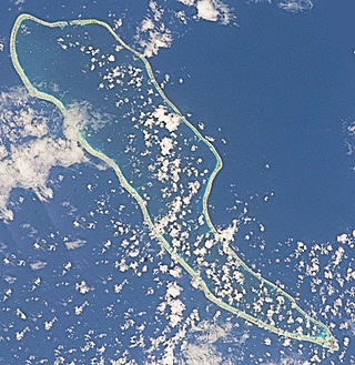
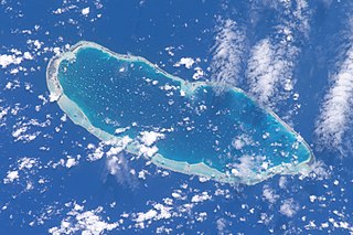
Rangiroa or Te Kokōta is the largest atoll in the Tuamotus and one of the largest in the world.

Mataiva, Tepoetiriura or Lazarev atoll is a coral atoll in the Tuamotu Archipelago. It is located in the Palliser group, and is the westernmost of the Tuamotus. The nearest atoll, Tikehau, is located 35 km to the east. Rangiroa is located 79 km to the east, and Tahiti is 311 km to the south.
Hao, or Haorangi, is a large coral atoll in the central part of the Tuamotu Archipelago. It has c. 1000 people living on 35 km2 (14 sq mi). It was used to house the military support base for the nuclear tests on Mururoa. Because of its shape, French explorer Louis Antoine de Bougainville named it "Île de la Harpe".

The Palliser Islands or Pallisers are a subgroup of the Tuamotu group in French Polynesia. They are located in the very northwest of the main group of atolls.
Funadhoo is one of the inhabited islands of the Shaviyani Atoll administrative division and geographically part of the Miladhummadulhu Atoll in the Maldives. Funadhoo is a very common Maldivian place name and is derived from the Dhivehi name for the tree Calophyllum inophyllum which grows on the shores of some islands. It is the administrative capital of Shaviyani Atoll.

The Îles Tuamotu-Gambier is an administrative division in French Polynesia. It consists of the Tuamotus and the Gambier Islands which are geographically located closely together.

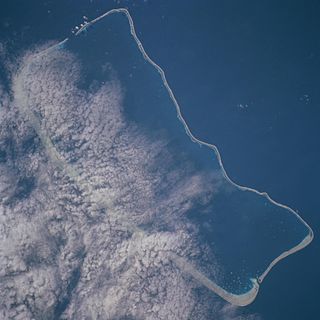
Makatea, or Mangaia-te-vai-tamae, is a raised coral atoll in the northwestern part of the Tuamotus, which is a part of the French overseas collectivity of French Polynesia. It is located 79 kilometres (49 mi) southwest from Rangiroa to the west of the Palliser group, which also is in French Polynesia. Makatea is surrounded by spectacular cliffs, rising to a plateau 80 metres (260 ft) above sea level. This island is 7.5 kilometres (4.7 mi) long, with a maximum width of 7 kilometres (4.3 mi) in the south. It is 24 square kilometres (9.3 sq mi) in area. Makatea is one of the only four islands of the Tuamotu Archipelago that do not take the form of a typical atoll.
Rangiroa Airport is an airport on the island of Rangiroa, French Polynesia. The airport is located on the northwestern edge of the atoll, 5.5 km southeast of Avatoru. The airport was built in 1965. Air Tahiti has regular daily flights connecting Rangiroa to other islands of French Polynesia. In 2018, 89,122 passengers utilized the airport.

Arutua, or Ngaru-atua is an atoll in the Tuamotu group in French Polynesia. It is located 40 km SW of Rangiroa. The closest land is Apataki Atoll, only 16 km to the East.
Fakarava, Havaiki-te-araro, Havai'i or Farea is an atoll in the west of the Tuamotu group in French Polynesia. It is the second largest of the Tuamotu atolls. The nearest land is Toau, a coral atoll which lies 14 kilometres to the northwest.

Tikehau or Porutu-kai is a coral atoll in the Palliser Islands group, part of the Tuamotu Archipelago in French Polynesia. It is included in the commune of Rangiroa.
Kaukura or Kaheko is an atoll in the Tuamotu group in French Polynesia, 48 km (30 mi) long and 15 km (9 mi) wide. It is in the western area of the archipelago, 58 km (36 mi) southeast of Rangiroa. The closest land is Apataki Atoll, 24 km (15 mi) to the northeast.

Maria Atoll is an uninhabited small atoll of the Tuamotu group in French Polynesia. It is located in the far southeast of the archipelago, about 72 km (45 mi) southwest from Marutea Sud. Maria's closest neighbour is the small atoll of Matureivavao of the Acteon Group, 56 km (35 mi) to the northwest.

Marutea Atoll, also known as Lord Hood Island, Marutea-i-runga, and Nuku-nui, is an atoll in the far southeast of the Tuamotu group of French Polynesia. It lies in the east-northeast part of the Gambier (commune), about 72 km northeast from Maria Atoll.

Anuanuraro is an atoll in French Polynesia, Pacific Ocean. It is part of the Duke of Gloucester Islands, a subgroup of the Tuamotu group. Anuanuraro's nearest neighbor is Anuanurunga, which is located about 29 km to the southeast.

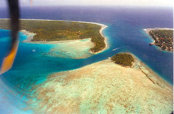
Avatoru Pass is located on the northwestern portion of the Rangiroa lagoon in the Tuamotu Islands of French Polynesia. It is located immediately to the West of the village of Avatoru. There are only two major passes on Rangiroa, the other being Tiputa Pass. The latter is located approximately 8 kilometres (5.0 mi) southeast of Avatoru Pass. The pass is a popular scuba diving location, although the Tiputa Pass is generally preferred by divers.

Tiputa is a village on the French Polynesian atoll of Rangiroa, in the Tuamotu archipelago.