Belgrano is a northern and leafy barrio or neighborhood of Buenos Aires, Argentina.
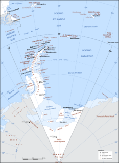
Argentine Antarctica is a sector of Antarctica claimed by Argentina as part of its national territory. It consists of the Antarctic Peninsula and a triangular section extending to the South Pole, delimited by the 25° West and 74° West meridians and the 60° South parallel. This region overlaps the British and Chilean claims in Antarctica. Argentina's Antarctic claim is based on its continued presence in the region since 1904, and the area's proximity to the South American continent. Argentina's claim to this area is subject to the Antarctic Treaty. Administratively, Argentine Antarctica is a department of the province of Tierra del Fuego, Antarctica, and South Atlantic Islands. The provincial authorities are based in Ushuaia. Despite of the claim to this Antarctic area, Argentine authority extends no further than the nation's bases. The South Orkney Islands are part of Islas del Atlántico Sur Department, which includes the British overseas territories of the Falkland Islands and the South Georgia and South Sandwich Islands.

The University of Belgrano is a private university established in 1964 and located in the Belgrano district of the city of Buenos Aires, Argentina.
San Nicolás is one of the neighbourhoods of Buenos Aires, Argentina, sharing most of the city and national government Neighborhood of Buenos Aires with neighboring Montserrat and home to much of the financial sector. It's referred usually as El Centro, and the part east of the 9 de Julio Avenue is known as Microcentro.

The Argentine National Historical Museum is located in Buenos Aires, Argentina, and is a museum dedicated to the history of Argentina, exhibiting objects relating to the May Revolution and the Argentine War of Independence.
Buenos Aires is a former passenger railway station in the city of Buenos Aires, Argentina. The station was terminus of the Belgrano Sur line that runs trains along Greater Buenos Aires region.

Barracas is a barrio, or district, in the southeast part of the city of Buenos Aires, Argentina. It is located between the railroad of Ferrocarril General Manuel Belgrano and the Riachuelo River, and the streets Regimiento de Patricios, Defensa, Caseros, Vélez Sársfield, Amancio Alcorta, Lafayette, and Lavardén. The name Barracas comes from the word barraca, which refers to a temporary construction of houses using rudimentary materials.

Vélez Sársfield is a barrio or district in the western part of Buenos Aires, Argentina, located in the area defined by the streets Segurola Avenue, Juan Agustín García, Lope de Vega Avenue, Juan B. Justo Ave., Corro Ave., Medina, Juan Bautista Alberdi Ave. and Mariano Acosta.

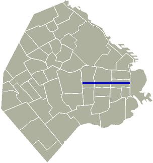
Avenida General Paz is a beltway freeway surrounding the city of Buenos Aires. Roughly following the boundary between the city and Buenos Aires Province, it is one of the few motorways in Argentina that is toll-free. It carries three lanes of traffic in each direction during most of its length, and five lanes between the Pan-American Highway and the Río de la Plata. There are feeder roads in both directions and there are service areas along its length, usually with a gas station and fast food restaurants.
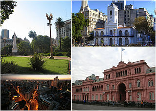
Monserrat or Montserrat is a neighbourhood in the east of the Buenos Aires CBD. The district features some of the most important public buildings in Buenos Aires, including city hall, the city legislature, Casa Rosada, the Colegio Nacional de Buenos Aires and the Libertador Building, among others.

Belgrano C is a sector within the barrio of Belgrano of Buenos Aires, Argentina, and is not officially recognised as one of the 48 barrios of Buenos Aires.

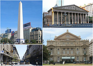
Plaza de la República is a city square in Buenos Aires, capital of Argentina. It is located in the San Nicolás quarter, at the intersection of the city's three main arteries: Ninth of July Avenue, Corrientes Avenue, and Diagonal Norte. It derives its name and associations from a church once sited on the square, San Nicolás de Bari, where the country's national flag was hoisted for the first time.
Avenida Roque Sáenz Peña, better known as Diagonal Norte, is an important avenue in the San Nicolás neighborhood of Buenos Aires, Argentina. It is oriented south-east/north-west, diagonally bisecting the city blocks (manzanas) which give the city centre a checkerboard plan. It is named after President Roque Sáenz Peña, who held power from 1910 to 1914 and passed the law which established universal suffrage, secret ballot and an electoral register.

Puente Alsina is an Argentine railway station in the Greater Buenos Aires neighbourhood of Valentín Alsina in the Lanús partido of Buenos Aires Province. The station takes its name from the nearby bridge of Puente Alsina over the Riachuelo River. On the other side of this bridge lies the neighbourhood of Nueva Pompeya within the city of Buenos Aires.
Avenida del Libertador is one of the principal thoroughfares in Buenos Aires, Argentina, and in points north, extending 25 km (16 mi) from the Retiro District of Buenos Aires to the northern suburb of San Fernando.

Avenida Figueroa Alcorta is a major thoroughfare in Buenos Aires, Argentina, with a length of over 7 km (4.3 mi) along the city's northside.

The Equestrian monument to General Manuel Belgrano is a landmark of Buenos Aires, Argentina. It is located at Plaza de Mayo, in front of the Casa Rosada. It depicts General Manuel Belgrano holding the Flag of Argentina, and it is made of bronze over a pedestal of granite.

The Ministry of Public Works Building, now known as the Ministry of Health Building is a public building in the rationalist style located on the intersection of 9 de Julio Avenue and Belgrano Avenue, in the neighborhood of Monserrat, in Buenos Aires, Argentina.

Avenida Presidente Julio Argentino Roca, better known as Diagonal Sur, is an important avenue in the Monserrat neighborhood of Buenos Aires, Argentina. It is oriented north-east/south-west, diagonally bisecting the city blocks (manzanas) which give the city centre a checkerboard plan. It is named after President Julio Argentino Roca, who held power from 1880 to 1886, and from 1896 to 1904.

Avenida General Sarmiento is an avenue located in the Palermo neighborhood, in Buenos Aires, Argentina. It runs from Plaza Italia to the Costanera Rafael Obligado Avenue, across the Parque Tres de Febrero.