| Awaroa River | |
|---|---|
 | |
| Location | |
| Country | New Zealand |
| Physical characteristics | |
| Mouth | Kaipara Harbour |
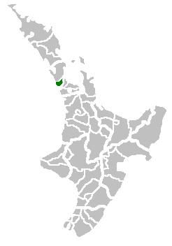
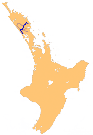
The Awaroa River is a river in the Kaipara District of New Zealand. [1]
| Awaroa River | |
|---|---|
| | |
| Location | |
| Country | New Zealand |
| Physical characteristics | |
| Mouth | Kaipara Harbour |
The Awaroa River is a river in the Kaipara District of New Zealand. [1]
Waitakere City was a territorial authority in West Auckland, New Zealand; it was governed by the Waitakere City Council from 1989 to 2010. It was New Zealand's fifth-largest city, with an annual growth of about 2%. In 2010 the council was amalgamated with the other authorities of the Auckland Region to form the current Auckland Council.

Moturoa / Rabbit Island is a small island that lies across the southernmost part of Tasman Bay / Te Tai-o-Aorere, on the northern coast of New Zealand's South Island. The long narrow island runs east–west for 8 kilometres (5 mi), and covers 15 km2 (5.8 sq mi).

Avondale railway station is on the Western Line of the Auckland railway network. Relocated in 2008, the station can be accessed from St Jude St, Layard St, and Crayford St.

The New Zealand Maritime Museum Hui Te Ananui A Tangaroa is a maritime museum in Auckland, New Zealand. It is located on Hobson Wharf, adjacent to the Viaduct Harbour in central Auckland. It houses exhibitions spanning New Zealand's maritime history, from the first Polynesian explorers and settlers to modern day triumphs at the America's Cup. Its Maori name is 'Te Huiteanaui-A-Tangaroa' – holder of the treasures of Tangaroa.
The Wairoa River in Northland New Zealand, sometimes referred to as the Northern Wairoa River, runs for 150 kilometres through the northern part of the North Auckland Peninsula. In the upper reaches, the river is formed from two separate rivers, the Mangakahia River and the Wairua River. The two streams meet to the northeast of Dargaville, becoming the Wairoa. It is the longest river in the Northland Region.

The Victoria Park Viaduct is a major motorway viaduct carrying the Auckland Northern Motorway over the Victoria Park area in the Auckland city centre, New Zealand. Construction began in 1959, and the bridge was opened on 5 April 1962. Due to the high traffic volumes passing through on their way to and from North Shore City, and because the viaduct is only four lanes wide in total, the bridge over the park is considered "one of the country's worst traffic bottlenecks", with around 200,000 vehicles a day.
The Arapaoa River is a northeastern arm of the Kaipara Harbour in Northland, New Zealand. Officially designated as a river, it is some 17 kilometres (11 mi) long and an average of 3 kilometres (2 mi) wide.
The Hakaru River is a river in the Northland Region of New Zealand. It starts in the Brynderwyn Hills and flows south to join the Topuni River exiting in the Oruawharo River, which forms part of the Kaipara Harbour.
The Kaiwaka River is a river of New Zealand's Northland Region. For much of its length, it is a broad arm of the Otamatea River, as much an inlet of the Kaipara Harbour as a true river.
The Kumengamatea River is a river of the Northland Region of New Zealand's North Island. It flows southwest into the Awaroa River close to the latter's outflow into the Wairoa River.
The Matakohe River is a river of the Northland Region of New Zealand's North Island. The river is a short tributary of the Arapaoa River, which it joins 15 kilometres (9 mi) east of Ruawai.
The Pahi River is a river of the Northland Region of New Zealand's North Island. It flows generally west from its origins southwest of Maungaturoto, and the last few kilometres of its length form an upper silty arm of the Kaipara Harbour. It forms one of the arms of the Arapaoa River, in the northeastern part of the harbour's system.
The Waihoihoi River is a river of the Northland Region of New Zealand's North Island. it is a tributary of the Waipu River, which it reaches close to the town of Waipu.
The Whakaki River is located in the Northland Region of New Zealand's North Island. Despite its name, it is better described as a silty arm of the Kaipara Harbour. It flows northwest to reach the Otamatea River.
The Whau Local Board is one of the 21 local boards of the Auckland Council. It is the only local board overseen by the council's Whau Ward councillor.
Mount Cambria is one of the volcanoes in the Auckland volcanic field. Located in the suburb of Devonport north-east of Mt Victoria, its 30-metre scoria cone was quarried away. The site is now Cambria Reserve.

Duders Hill was a 20 metre high scoria mound located on the Devonport coast, on the lower south-east slopes of Takarunga / Mount Victoria, in the Auckland volcanic field. It was mostly quarried away in the early 20th century
The Otamatea River is a river in the Northland Region. A short and wide river, it flows southwest and could be considered an arm of the northern Kaipara Harbour. The Otamatea is formed by the confluence of the Wairau and Kaiwaka rivers and the North Auckland Line crosses at this point. Almost 300 metres (330 yd) wide at its origin, the river widens to 1.8 kilometres (1.1 mi) by its mouth opposite Tinopai. Several other broad tidal creeks flow into the Otamatea, including Raepare Creek, Awaroa Creek, Takahoa Creek and the Whakaki River on the left bank and the Arapaoa River on the right.

Auckland District Health Board (ADHB) was a district health board that provided healthcare in the Auckland Region in New Zealand, mainly on the Auckland isthmus. This district health board existed between 2001 and 2022 and was governed by a part-elected, part-appointed board. In 2022, its functions and responsibilities were subsumed by Te Whatu Ora and Te Aka Whai Ora.

The Waitemata District Health Board was a district health board that provided healthcare to people living in the area that used to be covered by North Shore city, Rodney District, and Waitakere City in New Zealand. It was abolished on 1 July 2022, and replaced with Te Whatu Ora.
36°08′56″S174°04′12″E / 36.149°S 174.070°E