
The A3 is a motorway in northeast Switzerland, running diagonally from France toward the southeast border, and passing by Zürich on the way. The total length of the A3 motorway spans roughly 180 kilometres (110 mi), but parts of the road share sections of the A1 and A2 motorways.

The A13 is a motorway, at times an Autostrasse (expressway), which runs from St. Margrethen in northeastern Switzerland through to Ascona in southern Switzerland, crossing the main chain of the Alps in the Grisons area. It is the southern half of European route E43.

The A2 is a motorway in Switzerland. It forms Switzerland's main north-south axis from Basel to Chiasso, meandering with a slight drift toward the east. It lies on the Gotthard axis and crosses the Alps.
The Lopper Road Tunnel is a tunnel in central Switzerland. The tunnel connects Hergiswil in the canton of Nidwalden with Alpnach in the canton of Obwalden, and forms part of the A8 motorway. The tunnel was opened in 1984, and is 1,590 metres (5,220 ft) long. The tunnel has two lanes, and there is no central reservation. The tunnel runs under the Lopper, a shoulder of Mount Pilatus which extends into Lake Lucerne.

The Autostrade are roads forming the Italian national system of motorways. The total length of the system is about 6,758 kilometres (4,199 mi). In North and Central Italy, the Autostrade mainly consists of tollways managed by Atlantia S.p.A., a holding company controlled by the Benetton family. Other operators include ASTM, ATP, and Autostrade Lombarde in the north-west; Autostrada del Brennero, A4 Holding, Concessioni Autostradali Venete, and Autovie Venete in the north-east; Strada dei Parchi, SALT, SAT, and Autocisa in the center; and CAS in the south all under the supervision of the state-owned ANAS.

The A1 is a motorway in Switzerland. It follows Switzerland's main east–west axis, from St. Margrethen in northeastern Switzerland's canton of St. Gallen through to Geneva in southwestern Switzerland. The motorway spans 383 km. Besides the motorway's main route, it has several branches that are variously numbered A1a, A1h, A1l and A1.1. It was opened for the Swiss national exhibition of 1964.
Switzerland has a two-class highway system: motorways with separated roads for oncoming traffic and a standard maximal speed limit of 120 kilometres per hour (75 mph), and expressways often with oncoming traffic and a standard maximal speed limit of 100 kilometres per hour (62 mph).

Monte Ceneri is a mountain pass in the canton of Ticino in Switzerland. It connects the Magadino plain and the Vedeggio valley across the Lugano Prealps at an elevation of 554 metres (1,818 ft) above sea level. In so doing, it provides the most direct route between the cities of Bellinzona and Lugano. Despite its name, Monte Ceneri is the lowest point on the crest between Monte Tamaro and the Camoghè.

The A16, a motorway in north-central Switzerland, is a divided freeway connecting the border to France to the A5 motorway, 84 kilometres (52 mi) to the south on the Swiss plateau.
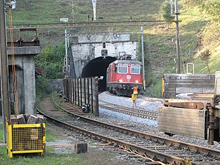
The Bözberg Railway is a railway line in Switzerland, running between Basel and Brugg via Pratteln, Rheinfelden, Stein-Säckingen, Frick and the Bözberg Tunnel. At Brugg it connects to Zürich via Baden and to the Gotthard Railway via the Aargauische Südbahn.
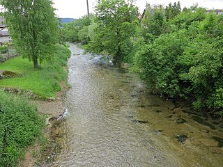
The Sissle is a 16-kilometre (10 mi) long river in the Swiss canton of Aargau in Switzerland. It is a tributary of the Rhine and drains the eastern part of the Fricktal. The largest town on the river is Frick.
The Lopper I Rail Tunnel is a railway tunnel in central Switzerland. The tunnel connects Hergiswil in the canton of Nidwalden with Alpnach in the canton of Obwalden. It forms part of the Zentralbahn Brünig line, which links Lucerne with Interlaken and the Bernese Oberland, between Hergiswil station and Alpnachstad station. It is 1,186 metres (3,891 ft) in length, and carries metre gauge track electrified at 11 kV AC 16 2/3 Hz using overhead catenary. The tunnel runs under the Lopper, a shoulder of Mount Pilatus which extends into Lake Lucerne.
The Lopper II Rail Tunnel is a railway tunnel in the canton of Nidwalden in central Switzerland. It forms part of the Zentralbahn Luzern–Stans–Engelberg line, which links Lucerne with Engelberg, between Hergiswil station and Stansstad station. It is 1,743 metres (5,719 ft) in length, and carries metre gauge track electrified at 11 kV AC 16 2/3 Hz using overhead catenary. The tunnel runs under the Lopper, a shoulder of Mount Pilatus which extends into Lake Lucerne, and immediately on leaving the tunnel the line crosses a bridge over the Alpnachersee arm of Lake Lucerne before entering Stansstad station.
Bözberg Tunnel may refer to two adjacent tunnels under the Bözberg Pass in the Swiss canton of Aargau:
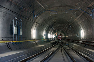
A ballastless track or slab track is a type of railway track infrastructure in which the traditional elastic combination of ties/sleepers and ballast is replaced by a rigid construction of concrete or asphalt.

Olten–Aarau railway is a railway line in the north of Switzerland. It runs from Olten along the Aare to Aarau.


