The Great Rift Valley is a series of contiguous geographic depressions, approximately 7,000 kilometres (4,300 mi) in total length, that runs from Lebanon in Asia to Mozambique in Southeast Africa. While the name continues in some usages, it is rarely used in geology as it is considered an imprecise merging of separate though related rift and fault systems.

Øresund or Öresund, commonly known in English as the Sound, is a strait which forms the Danish–Swedish border, separating Zealand (Denmark) from Scania (Sweden). The strait has a length of 118 kilometres (73 mi); its width varies from 4 kilometres (2.5 mi) to 28 kilometres (17 mi). The narrowest point is between Helsingør in Denmark and Helsingborg in Sweden.
Webster's Dictionary is any of the English language dictionaries edited in the early 19th century by Noah Webster (1758–1843), an American lexicographer, as well as numerous related or unrelated dictionaries that have adopted the Webster's name in his honor. "Webster's" has since become a genericized trademark in the United States for English dictionaries, and is widely used in dictionary titles.

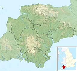
Torbay is a unitary authority with a borough status in the ceremonial county of Devon, England. It is governed by Torbay Council, based in the town of Torquay, and also includes the towns of Paignton and Brixham. The borough consists of 24.27 sq mi (62.9 km2) of land around the east-facing Tor Bay, part of Lyme Bay on the English Channel. A popular tourist destination, Torbay's sandy beaches, mild climate and recreational and leisure attractions have given rise to its nickname of the English Riviera. The neighbouring districts are South Hams and Teignbridge.

Merriam-Webster, Incorporated is an American company that publishes reference books and is mostly known for its dictionaries. It is the oldest dictionary publisher in the United States.

Korea(n) Bay, sometimes West Korea(n) Bay, is a bight and the northern extension of the Yellow Sea, between the southeastern coastline of China's Liaoning Province and the western coastline of North Korea's North Pyongan, South Pyongan and South Hwanghae provinces. It is separated from the Bohai Sea by the Liaodong Peninsula, with Dalian's Lüshunkou District marking its western end, and westernmost tip of North Korea's Ryongyon County as its eastern end.
A combe can refer either to a steep, narrow valley, or to a small valley or large hollow on the side of a hill; in any case, it is often understood simply to mean a small valley through which a watercourse does not run.

A body of water or waterbody is any significant accumulation of water on the surface of Earth or another planet. The term most often refers to oceans, seas, and lakes, but it includes smaller pools of water such as ponds, wetlands, or more rarely, puddles. A body of water does not have to be still or contained; rivers, streams, canals, and other geographical features where water moves from one place to another are also considered bodies of water.

Lyme Bay is an area of the English Channel off the south coast of England. The south western counties of Devon and Dorset front onto the bay.

Tor Bay is a bay on the south-east coast of the county of Devon, England. Facing east into the English Channel, it is about 4.5 mi (7.2 km) wide from north to south. The settlements of Torquay, Paignton and Brixham, which lie along its coastline, are known collectively as Torbay.
Sarana Valley is a valley in the mountains of northeastern Attu Island in the Aleutian Islands in Alaska.
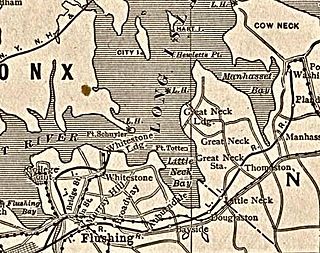
Little Neck Bay is an embayment in western Long Island, New York, off Long Island Sound. Little Neck Bay forms the western boundary of the Great Neck Peninsula, the eastern boundary of which is Manhasset Bay. The political boundary between Nassau County and the borough of Queens runs through the bay, bordering the neighborhood of Douglaston–Little Neck.

Cape Charles is a headland, or cape, in Northampton County, Virginia. Located at the southern tip of Northampton County, it forms the southern tip of the Delmarva Peninsula and the northern side of the entrance to the Chesapeake Bay. Cape Charles was named in honor of Charles I of England, the second son of King James I and his eventual successor to the thrones of England, Scotland, and Ireland.

Absecon Inlet is a narrow strait on the southeastern coast of New Jersey, United States.
The Matagorda Peninsula is a narrow spit of land on the southeastern coast of Texas in the United States.

Kagoshima Bay also known as Kinkō Bay, Kinko Bay is a deep inlet of the East China Sea on the coast of Japan.
Corson Inlet is a narrow strait on the southern coast of New Jersey in the United States.
The Porthos Range is the second range south in the Prince Charles Mountains of Antarctica, extending for about 30 miles in an east-to-west direction between Scylla Glacier and Charybdis Glacier. First visited in December 1956 by the Australian National Antarctic Research Expeditions (ANARE) southern party under W.G. Bewsher (1956-57) and named after Porthos, a character in Alexandre Dumas, père's novel The Three Musketeers, the most popular book read on the southern journey.

Hope's Nose is a coastal headland, separating Tor Bay from Babbacombe Bay. It is visible from much of the town and harbour of Torquay, Devon. It has been a Site of Special Scientific Interest along with the nearby Wall's Hill since 1986.