Bachumer Bach

Last updated

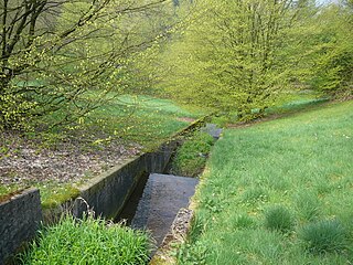
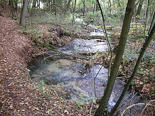
Bachumer Bach is a small (2,938 meter long) river in North Rhine-Westphalia, Germany. The stream rises north of the town of Dreihausen (belonging to Bachum) at an altitude of 238 meters above sea level and flows in a northerly direction to 149 meters above sea level then flows into the Ruhr near Neheim.

Bachumer Bach
Bachumer Bach.jpg
Location
Country Germany
State North Rhine-Westphalia
CityDreihausen
Physical characteristics
SourceNorth of Dreihausen in Bachum
  location Germany
  coordinates 51°27′2″N7°55′45″E / 51.45056°N 7.92917°E / 51.45056; 7.92917
  elevation238 m (781 ft)
Mouth Border between Bachum and Neheim
  coordinates
51°28′10″N7°56′42″E / 51.46944°N 7.94500°E / 51.46944; 7.94500
  elevation
149 m (489 ft)
Length2.938 km (1.826 mi)
Basin features
Progression RuhrRhineNorth Sea


See also


Related Research Articles

<span class="mw-page-title-main">Main (river)</span> River in Germany

The Main is the longest tributary of the Rhine. It rises as the White Main in the Fichtel Mountains of northeastern Bavaria and flows west through central Germany for 525 kilometres (326 mi) to meet the Rhine below Rüsselsheim, Hesse. The cities of Mainz and Wiesbaden are close to the confluence.

<span class="mw-page-title-main">Rhine</span> Major river in Western Europe

The Rhine is one of the major European rivers. The river begins in the Swiss canton of Graubünden in the southeastern Swiss Alps. It forms part of the Swiss-Liechtenstein, Swiss-Austrian, and Swiss-German borders. After that the Rhine defines much of the Franco-German border, after which it flows in a mostly northerly direction through the German Rhineland. Finally in Germany, the Rhine turns into a predominantly westerly direction and flows into the Netherlands where it eventually empties into the North Sea. It drains an area of 9,973 sq km and its name derives from the Celtic Rēnos. There are also two German states named after the river, North Rhine-Westphalia and Rhineland-Palatinate.

<span class="mw-page-title-main">North Rhine-Westphalia</span> State in Germany

North Rhine-Westphalia or North-Rhine/Westphalia, commonly shortened to NRW, is a state (Land) in Western Germany. With more than 18 million inhabitants, it is the most populous state in Germany. Apart from the city-states, it is also the most densely populated state in Germany. Covering an area of 34,084 square kilometres (13,160 sq mi), it is the fourth-largest German state by size.

<span class="mw-page-title-main">IJssel</span> River in the Netherlands

The IJssel is a Dutch distributary of the river Rhine that flows northward and ultimately discharges into the IJsselmeer, a North Sea natural harbour. It more immediately flows into the east-south channel around the Flevopolder, Flevoland which is kept at 3 metres below sea level. This body of water is then pumped up into the IJsselmeer.

<span class="mw-page-title-main">Lüdenscheid</span> Town in North Rhine-Westphalia, Germany

Lüdenscheid is a city in the Märkischer Kreis district, in North Rhine-Westphalia, Germany. It is located in the Sauerland region.

<span class="mw-page-title-main">Ahr</span> River in Germany

Ahr is a river in Germany, a left tributary of the Rhine. Its source is at an elevation of approximately 470 metres (1,540 ft) above sea level in Blankenheim in the Eifel, in the cellar of a timber-frame house near the castle of Blankenheim. After 18 kilometres (11 mi) it crosses from North Rhine-Westphalia into Rhineland-Palatinate.

<span class="mw-page-title-main">Volme</span> River in Germany

The Volme is a river in North Rhine-Westphalia, Germany, and is a tributary of the river Ruhr. It is 50.5 kilometres (31.4 mi) long, of which about 21 km (13 mi) lie within the city limits of Hagen. Its largest tributary is the Ennepe.

<span class="mw-page-title-main">Rur</span> River in Germany and the Netherlands

The Rur or Roer is a major river that flows through portions of Belgium, Germany and the Netherlands. It is a right (eastern) tributary to the Meuse. About 90 percent of the river's course is in Germany.

<span class="mw-page-title-main">Barnacken</span>

At 446.4 m above sea level (NN) the Barnacken is the highest hill in the Teutoburg Forest in the German state of North Rhine-Westphalia.

<span class="mw-page-title-main">Bröl</span> River in Germany

The Bröl is a 45.1 km long right tributary of the Sieg in North Rhine-Westphalia, Germany.

<span class="mw-page-title-main">Aa (Möhne)</span> River in Germany

Aa is a river of North Rhine-Westphalia, Germany. It is 7.4 kilometres (4.6 mi) long and is a left tributary of the Möhne in Brilon. The river has a watershed of 23.071 square kilometres (8.908 sq mi).

Bermecke is a stream in North Rhine-Westphalia, Germany.

<span class="mw-page-title-main">Diestelbach</span> River in Germany

Diestelbach is a river in the district of Lippe in the eastern part of North Rhine-Westphalia, Germany. Also known as the Diestel, it is a tributary of the Emmer.

Kielhackensiepen is a small river of North Rhine-Westphalia, Germany. It is a right tributary of the Möhne. The stream rises about 3 kilometers north of Scharfenberg at an altitude of 450 meters above sea level. From here it initially flows in a southwesterly direction. In the further course, the direction of the river changes to predominantly westerly directions. The Kielhackensiepen flows into the federal highway 516 at an altitude of 350 meters above sea level. The roughly 33.7 hectare catchment area is drained to the North Sea via the Möhne, Ruhr and Rhine.

Kleine Aa is a river of North Rhine-Westphalia, Germany, a tributary of the Aabach. Thus it is part of the Rhine River Basin.

<span class="mw-page-title-main">Köhm</span> River in Germany

Köhm is a small river of North Rhine-Westphalia, Germany. It flows into the Niers near Erkelenz-Keyenberg. Its upper course no longer exists due to lignite mining.

Rospebach is a river of North Rhine-Westphalia, Germany. It flows into the Agger near Gummersbach. The source of the Rospebach lies on the southern slopes of the Arzhöhe, about 800 m southeast of the Gummersbach district Herreshagen at an altitude of 317 m above sea level. From here it flows primarily south through Wasserfuhr, Gummersbach and Mühle before joining the Agger in Vollmerhausen at 168 m above sea level. On its way from the source to the mouth the Rospebach overcomes 149 meters of altitude, which corresponds to an average bed slope of 18.2 ‰.

<span class="mw-page-title-main">Weiß (Sieg)</span> River in Germany

The Weiß is a river of North Rhine-Westphalia, Germany, which is 18.1 kilometers (11.2 mi) in length. Its source is near the mountain Kalteiche, at a height of 493 meters (1,617 ft) above sea level. Then it flows through the villages Wilgersdorf, Rudersdorf, Anzhausen, Niederdielfen, Kaan-Marienborn, and the city Siegen. The Weiß flows into the Sieg in Siegen, at 247 meters elevation.

<span class="mw-page-title-main">Wenne</span> River in Germany

Wenne is a river of North Rhine-Westphalia, Germany. The river springs in a forest area near Obringhausen.

<span class="mw-page-title-main">Sindernbach</span> River in North Rhine-Westphalia, Germany

Sindernbach is a river of North Rhine-Westphalia, Germany, which is 3.58 kilometers in length. It has its source on the east of the mountain Lahnkopf in the Rothaar Mountains in an elevation of 570 meters, and it flows into the river Sieg in the village of Nenkersdorf in an elevation of 365 meters above sea level.