Related Research Articles
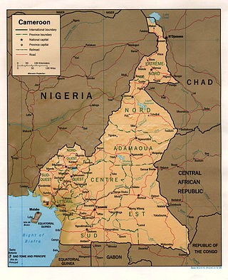
At 475,440 km2 (183,570 sq mi), Cameroon is the world's 53rd largest country. It is slightly larger than the nation of Sweden and the US state of California. It is comparable in size to Papua New Guinea. Cameroon's landmass is 472,710 km2 (182,510 sq mi), with 2,730 km2 (1,050 sq mi) of water.

Yaoundé is the capital of Cameroon and, with a population of more than 2.8 million, the second-largest city in the country after the port city Douala. It lies in the Centre Region of the nation at an elevation of about 750 metres (2,500 ft) above sea level.

Bafia is a Cameroonian town and commune in the Centre Province region. It is the capital of the Mbam-et-Inoubou department. It lies 120 km (75 mi) north of the country's capital Yaoundé. Bafia has approximately 55,700 inhabitants, making it the third largest city in the province after Yaoundé and Mbalmayo. Most citizens belong to either the Bafia people or the Yambassa people. It is the see of the eponymous diocese.

Banyo is a town and commune in Adamawa Province, Cameroon. It is located at around 6.78°N 11.82°E, and is predominantly Muslim. Though a government prefect serves in the town, the lamido still holds great sway among the population. The current lamido, S.E. Mohaman Gabdo Yahya, has written his own history (2009). The geographer Jean Hurault has published on the demography of the area, and summarized some of the history in his 1955 work. In the nineteenth century, Banyo separated from Koncha and Tibati.
Etuko is a village in Cameroon located in the Department of Manyu in the Southwest Region. It is administratively attached to the district of Upper Bayang and to the canton of Bachuo Akagbe. The village is located 43 kilometres (27 mi) from Mamfe and 105 km (65 mi) from Bamenda.

Nkambe is a city in the Northwest Region of Cameroon. It is the headquarters of the Mantungia department. Nkambe Central is also the name of one of the five communes in Donga-Mantung. Nkambe lies at the north edge of the Bamenda Grassfields, on the northeast arc of the Ring Road, farthest from Bamenda. The Nigerian border is only 25 or 40 km away, but roads toward the border are undeveloped jungle tracks.
Minim is a village in the commune of Martap, in the department of Vina, in the Adamawa Region, Cameroon. The village contains Cameroon's main source of bauxite.
Alme is a village in the commune of Mayo-Baléoin Adamawa Region, Cameroon, near the border with Nigeria.
Bobbodji is a village in the commune of Martap, in the Adamawa Region of Cameroon.
Galdi is a village in the commune of Nyambaka, in the Adamawa Region of Cameroon, in the south-eastern part of the Adamawa Plateau.
Hangloa is a village in the commune of Martap, in the Adamawa Region of Cameroon.
Idool is a village in the commune of Belel in the Adamawa Region of Cameroon, on the road from Ngaoundéré to Bebel and Mbang.
Likok-Kouba is a village in the commune of Martap, in the Adamawa Region of Cameroon.
Pawati is a village in the commune of Mayo-Baléo in the Adamawa Region of Cameroon, near the border with Nigeria.
Walkossam is a village in the commune of Tignère, in the Adamawa Region of Cameroon.
Tabenken, also known as Tangmbo, is a village in the Cameroon in the department of Donga-Mantung, Northwest Region near the border of Nigeria. It is part of commune of Nkambé.

Upper Bayang is a district of Cameroon located in the Manyu department and the South West region. The district seat is located at Tinto. Home to the Banyangi people.
Sumbe is a locality of Cameroon located in the South West Region and the department of Manyu. It is administratively attached to the district of Upper Bayang and the township of Tinto.
References
- ↑ Dictionary of the villages of the Manyu, ORSTOM Center in Yaoundé, 1973, p. 26(PDF) http://horizon.documentation.ird.fr/exl-doc/pleins_textes/divers08-01/02887.pdf.
{{cite web}}: Missing or empty|title=(help) - ↑ "Dictionary of the villages of the Manyu , Center ORSTOM of Yaoundé, 1973, p. 26 [ read online [ archive ]]" (PDF).
- ↑ "CETIC de Bachuo Akagbe, Schoolmap Cameroon". Archived from the original on 2018-11-06. Retrieved 2023-02-17.
5°41′23″N9°26′18″E / 5.68972°N 9.43833°E
| | This Southwest Region (Cameroon) location article is a stub. You can help Wikipedia by expanding it. |