Related Research Articles

Oceanic trenches are prominent, long, narrow topographic depressions of the ocean floor. They are typically 50 to 100 kilometers wide and 3 to 4 km below the level of the surrounding oceanic floor, but can be thousands of kilometers in length. There are about 50,000 km (31,000 mi) of oceanic trenches worldwide, mostly around the Pacific Ocean, but also in the eastern Indian Ocean and a few other locations. The greatest ocean depth measured is in the Challenger Deep of the Mariana Trench, at a depth of 10,920 m (35,830 ft) below sea level.
Subduction is a geological process in which the oceanic lithosphere and some continental lithosphere is recycled into the Earth's mantle at convergent boundaries. Where the oceanic lithosphere of a tectonic plate converges with the less dense lithosphere of a second plate, the heavier plate dives beneath the second plate and sinks into the mantle. A region where this process occurs is known as a subduction zone, and its surface expression is known as an arc-trench complex. The process of subduction has created most of the Earth's continental crust. Rates of subduction are typically measured in centimeters per year, with rates of convergence as high as 11 cm/year.

Sedimentary basins are region-scale depressions of the Earth's crust where subsidence has occurred and a thick sequence of sediments have accumulated to form a large three-dimensional body of sedimentary rock. They form when long-term subsidence creates a regional depression that provides accommodation space for accumulation of sediments. Over millions or tens or hundreds of millions of years the deposition of sediment, primarily gravity-driven transportation of water-borne eroded material, acts to fill the depression. As the sediments are buried, they are subject to increasing pressure and begin the processes of compaction and lithification that transform them into sedimentary rock.
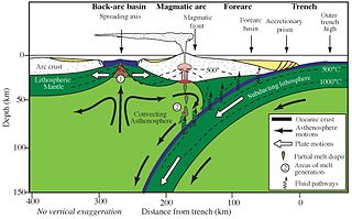
Forearc is a plate tectonic term referring to a region in a subduction zone between an oceanic trench and the associated volcanic arc. Forearc regions are present along convergent margins and eponymously form 'in front of' the volcanic arcs that are characteristic of convergent plate margins. A back-arc region is the companion region behind the volcanic arc.
A volcanic arc is a belt of volcanoes formed above a subducting oceanic tectonic plate, with the belt arranged in an arc shape as seen from above. Volcanic arcs typically parallel an oceanic trench, with the arc located further from the subducting plate than the trench. The oceanic plate is saturated with water, mostly in the form of hydrous minerals such as micas, amphiboles, and serpentines. As the oceanic plate is subducted, it is subjected to increasing pressure and temperature with increasing depth. The heat and pressure break down the hydrous minerals in the plate, releasing water into the overlying mantle. Volatiles such as water drastically lower the melting point of the mantle, causing some of the mantle to melt and form magma at depth under the overriding plate. The magma ascends to form an arc of volcanoes parallel to the subduction zone.

The Indonesian island of Sumatra is located in a highly seismic area of the world. In addition to the subduction zone off the west coast of the island, Sumatra also has a large strike-slip fault, the Great Sumatran Fault also known as Semangko Fault, running the entire length of the island. This fault zone accommodates most of the strike-slip motion associated with the oblique convergence between the Indo-Australian and Eurasian plates. The fault ends in the north just below the city of Banda Aceh, which was devastated in the 2004 Indian Ocean earthquake. After the December 2004 earthquake, pressure on the Great Sumatran Fault has increased tremendously, especially in the north.

A back-arc basin is a type of geologic basin, found at some convergent plate boundaries. Presently all back-arc basins are submarine features associated with island arcs and subduction zones, with many found in the western Pacific Ocean. Most of them result from tensional forces, caused by a process known as oceanic trench rollback, where a subduction zone moves towards the subducting plate. Back-arc basins were initially an unexpected phenomenon in plate tectonics, as convergent boundaries were expected to universally be zones of compression. However, in 1970, Dan Karig published a model of back-arc basins consistent with plate tectonics.

The Rivera Plate is a small tectonic plate located off the west coast of Mexico, just south of the Baja California Peninsula. It is bounded on the northwest by the East Pacific Rise, on the southwest by the Rivera Transform Fault, on the southeast by a deformation zone, and on the northeast by the Middle America Trench and another deformation zone.

The Izu–Bonin–Mariana (IBM) arc system is a tectonic plate convergent boundary in Micronesia. The IBM arc system extends over 2800 km south from Tokyo, Japan, to beyond Guam, and includes the Izu Islands, the Bonin Islands, and the Mariana Islands; much more of the IBM arc system is submerged below sealevel. The IBM arc system lies along the eastern margin of the Philippine Sea Plate in the Western Pacific Ocean. It is the site of the deepest gash in Earth's solid surface, the Challenger Deep in the Mariana Trench.
An accretionary wedge or accretionary prism forms from sediments accreted onto the non-subducting tectonic plate at a convergent plate boundary. Most of the material in the accretionary wedge consists of marine sediments scraped off from the downgoing slab of oceanic crust, but in some cases the wedge includes the erosional products of volcanic island arcs formed on the overriding plate.

The Chile Triple Junction is a geologic triple junction located on the seafloor of the Pacific Ocean off Taitao and Tres Montes Peninsula on the southern coast of Chile. Here three tectonic plates meet: the South American Plate, the Nazca Plate and the Antarctic Plate. This triple junction is unusual in that it consists of a mid-oceanic ridge, the Chile Rise, being subducted under the South American Plate at the Peru–Chile Trench. The Chile Triple Junction is the boundary between the Chilean Rise and the Chilean margin, where the Nazca, Antarctic, and South American plates meet at the trench.

The North Bismarck Plate is a small tectonic plate located in the Bismarck Sea off the northeast coast of New Guinea. It is currently regarded as a relic or inactive plate by most. At one time it was called the Manus Plate, but this term was later used for a modelled microplate at the south east boundary of the North Bismarck Plate.

The Nazca Ridge is a submarine ridge, located on the Nazca Plate off the west coast of South America. This plate and ridge are currently subducting under the South American Plate at a convergent boundary known as the Peru-Chile Trench at approximately 7.7 cm (3.0 in) per year. The Nazca Ridge began subducting obliquely to the collision margin at 11°S, approximately 11.2 Ma, and the current subduction location is 15°S. The ridge is composed of abnormally thick basaltic ocean crust, averaging 18 ±3 km thick. This crust is buoyant, resulting in flat slab subduction under Peru. This flat slab subduction has been associated with the uplift of Pisco Basin and the cessation of Andes volcanism and the uplift of the Fitzcarrald Arch on the South American continent approximately 4 Ma.

The Hellenic Trench (HT) is an oceanic trough located in the forearc of the Hellenic Arc, an arcuate archipelago on the southern margin of the Aegean Sea Plate, or Aegean Plate, also called Aegea, the basement of the Aegean Sea. The HT begins in the Ionian Sea near the mouth of the Gulf of Corinth and curves to the south, following the margin of the Aegean Sea. It passes close to the south shore of Crete and ends near the island of Rhodes just offshore Anatolia.
The back-arc region is the area behind a volcanic arc. In island volcanic arcs, it consists of back-arc basins of oceanic crust with abyssal depths, which may be separated by remnant arcs, similar to island arcs. In continental arcs, the back-arc region is part of continental platform, either dry land (subaerial) or forming shallow marine basins.
In geology, the slab is a significant constituent of subduction zones.
The Sumatra Trench is a part of the Sunda Trench or Java Trench. The Sunda subduction zone is located in the east part of Indian Ocean, and is about 300 km (190 mi) from the southwest coast of Sumatra and Java islands. It extends over 5,000 km (3,100 mi) long, starting from Myanmar in the northwest and ending at Sumba Island in the southeast.

The subduction tectonics of the Philippines is the control of geology over the Philippine archipelago. The Philippine region is seismically active and has been progressively constructed by plates converging towards each other in multiple directions. The region is also known as the Philippine Mobile Belt due to its complex tectonic setting.
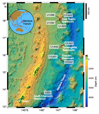
Mud volcanoes in the Mariana fore-arc are a hydrothermal geologic landform that erupt slurries of mud, water, and gas. There are at least 10 mud volcanoes in the Mariana fore-arc that are actively erupting, including the recently studied Conical, Yinazao, Fantagisna, Asut Tesoro, and South Chamorro serpentinite mud volcanoes. These mud volcanoes erupt a unique serpentinite mud composition that is related to the geologic setting in which they have formed. Serpentinite mud is the product of mantle metasomatism due to subduction zone metamorphism and slab dehydration. As a result, the serpentinite mud that erupts from these mud volcanoes often contains pieces of mantle peridotite material that has not fully altered during the serpentinization process. In addition to pieces of altered mantle material, pieces of subducted seamounts have also been found within the serpentinite muds. Serpentinite mud volcanoes in the Mariana fore-arc are often located above faults in the fore-arc crust. These faults act as conduits for the hydrated mantle material to ascend towards the surface. The Mariana mud volcanoes provide a direct window into the process of mantle hydration that leads to the production of arc magmas and volcanic eruptions.

Oblique subduction is a form of subduction for which the convergence direction differs from 90° to the plate boundary. Most convergent boundaries involve oblique subduction, particularly in the Ring of Fire including the Ryukyu, Aleutian, Central America and Chile subduction zones. In general, the obliquity angle is between 15° and 30°. Subduction zones with high obliquity angles include Sunda trench and Ryukyu arc.
References
- ↑ Byrne, Daniel E.; Wang, Wei-hau; Davis, Dan M. (1993). "Mechanical role of backstops in the growth of forearcs". Tectonics. 12 (1): 123–144. Bibcode:1993Tecto..12..123B. doi:10.1029/92TC00618.
- 1 2 3 Kopp, Heidrun; Kukowski, Nina (2003). "Backstop geometry and accretionary mechanics of the Sunda margin". Tectonics. 22 (6): 1072. Bibcode:2003Tecto..22.1072K. doi: 10.1029/2002TC001420 .
| | This article about geological processes is a stub. You can help Wikipedia by expanding it. |
| | This tectonics article is a stub. You can help Wikipedia by expanding it. |