Related Research Articles

Basseterre is the capital and largest city of Saint Kitts and Nevis with an estimated population of 14,000 in 2018. Geographically, the Basseterre port is located at 17°18′N62°44′W, on the south western coast of Saint Kitts Island, and it is one of the chief commercial depots of the Leeward Islands. The city lies within Saint George Basseterre Parish.

St. George's is the capital of Grenada. The town is surrounded by a hillside of an old volcano crater and is located on a horseshoe-shaped harbour.

Tobago is an island and ward within the Republic of Trinidad and Tobago. It is located 35 kilometres (22 mi) northeast of the larger island of Trinidad and about 160 kilometres (99 mi) off the northeastern coast of Venezuela. It lies to the southeast of Grenada.

Nord-Est or Nodès is one of the ten departments of Haiti, located in northern Haiti. It has an area of 1,623 km2 (627 sq mi), making it the smallest of all the departments. It had an estimated population of 393,967 as of 2015. Its capital is Fort-Liberté. It was a part of the Nord department.

Fort Zeelandia is a fortress in Paramaribo, Suriname. In 1640 the French built a wooden fort on the spot which, during British colonial period, was reinforced and became Fort Willoughby. It was taken by the Dutch in 1667 and renamed Fort Zeelandia.

Gros Islet District, one of 10 first order subdivision of the Caribbean island nation of Saint Lucia which includes the island's northernmost point, Cap Point and the notable Cap Estate, where the renowned St. Lucia Golf and Country Club is located. Whilst the town of Gros Islet is an important administrative centre, Rodney Bay is the main financial center of the district.
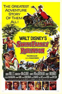
Swiss Family Robinson is a 1960 American adventure film starring John Mills, Dorothy McGuire, James MacArthur, Janet Munro, Tommy Kirk, and Kevin Corcoran in a tale of a shipwrecked family building an island home. It was the second feature film based on the 1812 novel The Swiss Family Robinson by Johann David Wyss, a previous adaptation having been released by RKO Pictures in 1940. Directed by Ken Annakin and shot in Tobago and Pinewood Studios outside London, it was the first widescreen Walt Disney Pictures film shot with Panavision lenses; when shooting in widescreen, Disney had almost always used a matted wide screen or filmed in CinemaScope.

Scarborough is a major town of the Island of Tobago as well as the eleventh-most-populous in Trinidad and Tobago. Scarborough was the capital of Tobago in 1769 before it was unified with Trinidad changing the capital to Port of Spain. Situated in western Tobago, Scarborough is the economic and cultural centre of the island of Tobago. The estimated population in 2011 was 17,537. Scarborough is ranked as one of Trinidad and Tobago's most densely populated towns alongside Port of Spain, San Fernando, Chaguanas and Arima. The town's skyline is dominated by Fort King George, an 18th-century fortification named after King George III, which now hosts a historic and archaeologic museum. Scarborough's deepwater harbour was built in 1991; before that ships were forced to anchor offshore.

Lake George, nicknamed the Queen of American Lakes, is a long, narrow oligotrophic lake located at the southeast base of the Adirondack Mountains, in the northeastern portion of the U.S. state of New York. It lies within the upper region of the Great Appalachian Valley and drains all the way northward into Lake Champlain and the St. Lawrence River drainage basin. The lake is situated along the historical natural (Amerindian) path between the valleys of the Hudson and St. Lawrence Rivers, and so lies on the direct land route between Albany, New York, and Montreal, Quebec, Canada. The lake extends about 32.2 mi (51.8 km) on a north–south axis, is 187 ft (57 m) deep, and ranges from one to three miles in width, presenting a significant barrier to east–west travel. Although the year-round population of the Lake George region is relatively small, the summertime population can swell to over 50,000 residents, many in the village of Lake George region at the southern end of the lake.

Saint Mary is a parish located in the northeast section of Jamaica. With a population of 114,227 it is one of Jamaica's smallest parishes, located in the county of Middlesex. Its chief town and capital is Port Maria, located on the coast. It is also the birthplace of established dancehall reggae artists, such as Capleton, Lady Saw, Ninjaman, Ini Kamoze, Sizzla, and Tanya Stephens. Other notable residents of St. Mary parish include bestselling author Colin Simpson, who is the great-great grandson of noted slavery abolitionist James Phillippo, famed Jamaican writer and community activist Erna Brodber, and acclaimed music producer Chris Blackwell who is credited with "discovering" Bob Marley.

The Curonian colonization of the Americas was performed by the Duchy of Courland and Semigallia, which was the second-smallest state to colonise the Americas, after the Knights of Malta. It had a colony on the island of Tobago from 1654 to 1659 and intermittently from 1660 to 1689.
Speyside is a village in northern Tobago within Saint John Parish. It lies on the leeward coast, across from the island of Little Tobago, 26 km northeast of Scarborough, overlooking Tyrrel's Bay. At the census of population in 2000, the town had a population of 1100.

St. James is a suburban parish, located on the north-west end of the island of Jamaica in the county of Cornwall. Its capital is Montego Bay. Montego Bay was officially named the second city of Jamaica, behind Kingston, in 1981, although Montego Bay became a city in 1980 through an act of the Jamaican Parliament. The parish is the birthplace of the Right Excellent Samuel Sharpe, one of Jamaica's seven National Heroes.
Port Antonio is the capital of the parish of Portland on the northeastern coast of Jamaica, about 100 km from Kingston. It had a population of 12,285 in 1982 and 13,246 in 1991. It is the island's third largest port, famous as a shipping point for bananas and coconuts, as well as one of its most important tourist attractions, tourism being a major contributor to the town's economy.

The 2009 CONCACAF U-20 Championship was the biannual CONCACAF youth championship tournament for under-20 national teams. The 2009 edition was held in Trinidad and Tobago. All matches were played at Dwight Yorke Stadium in Bacolet, Tobago and Marvin Lee Stadium in Macoya, Trinidad. The CONCACAF U-20 Championship traditionally serves as the CONCACAF qualifier for the FIFA U-20 World Cup, and under the 2009 tournament format the four semifinalists qualified for the 2009 FIFA U-20 World Cup, which was hosted by Egypt from 25 September to 16 October 2009.
Vieux Fort Comprehensive Secondary School or V.F.C.S.S located in the Caribbean island of Saint Lucia has two Campuses. Campus A consists of Forms 1 and 2 whilst Campus B consists of Forms 3 to 5. Although now Campus A and B are becoming full-fledged secondary schools. A the moment Campus B educates students of Form 1, 2, 3, 4 and 5.
The 34th CARIFTA Games was held in the Dwight Yorke Stadium in Bacolet, Tobago on March 26–28, 2005. The event was relocated from the National Stadium, St. George's, Grenada, because of the aftermath of Hurricane Ivan destroying 90 percent of the island's houses. An appraisal of the results has been given.
A total of 25 teams entered the qualification process for the 2012 Caribbean Cup, competing for a total of 8 spots in the final tournament. Jamaica, as the holders, and Antigua and Barbuda, as hosts, qualified automatically, leaving 6 spots open for competition.
The Claude Noel Highway, sometimes referred to as CNH, is one of the major west–east highways in Trinidad and Tobago, named after Claude Noel, it is the only highway in Tobago. It runs from Canaan to Scarborough.
Fort Granby was built in Tobago c. 1765 by the British to protect the first capital, George Town. The fort was probably named for the Marquess of Granby.
References
- ↑ "View from Fort King George over Bacolet Bay, Tobago". www.fotoreiseberichte.de, Gaby Schulemann-Maier. 2004. Archived from the original on 2010-11-21.
11°10′00″N60°43′00″W / 11.1667°N 60.7167°W
| | This Trinidad and Tobago location article is a stub. You can help Wikipedia by expanding it. |