Tigranes is the Greek transliteration of the Old Iranian name *Tigrāna. This was the name of a number of historical figures, primarily kings of Armenia.

Adiabene was an ancient kingdom in northern Mesopotamia, corresponding to the northwestern part of ancient Assyria. The size of the kingdom varied over time; initially encompassing an area between the Zab Rivers, it eventually gained control of Nineveh and starting at least with the rule of Monobazos I, Gordyene became an Adiabenian dependency. It reached its zenith under Izates II, who was granted the district of Nisibis by the Parthian king Artabanus II as a reward for helping him regain his throne. Adiabene's eastern borders stopped at the Zagros Mountains, adjacent to the region of Media. Arbela served as the capital of Adiabene.

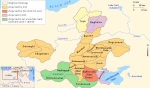
Arzanene or Aghdznik was a historical region in the southwest of the ancient kingdom of Armenia. It was ruled by one of the four bdeashkhs of Armenia, the highest ranking nobles below the king who ruled over the kingdom's border regions. Its probable capital was the fortress-city of Arzen. The region briefly became home to the capital of Armenia during the reign of Tigranes the Great, who built his namesake city Tigranocerta there. Arzanene was placed under the direct suzerainty of the Roman Empire after the Peace of Nisibis in 298. It was briefly brought back under Armenian control c. 371 but was soon lost again following the partition of Armenia in 387.

Mamikonian, or Mamikonean, was an Armenian aristocratic dynasty which dominated Armenian politics between the 4th and 8th centuries. They were the most notable noble house in Early Christian Armenia after the ruling Arsacid dynasty and held the hereditary positions of sparapet and dayeak, allowing them to play the role of kingmaker for the later Armenian kings. They ruled over extensive territories, including the Armenian regions of Tayk, Taron, Sasun, and Bagrevand, among others. The Mamikonians had a reputation as supporters of the Roman Empire in Armenia against Sasanian Iran, although they also served as viceroys under Persian rule. Their influence over Armenian affairs began to decline at the end of the 6th century and suffered a final, decisive blow after a failed rebellion against Arab rule over Armenia in 774/75.
Pahlavuni was an Armenian noble family, a branch of the Kamsarakan, that rose to prominence in the late 10th century during the last years of the Bagratuni monarchy.

Moxoene or Mokk' was a territory of Kingdom of Armenia and later Sasanian Armenia, located east of Arzanene from south of Lake Van to north of Bohtan river. The territory was ruled by a local dynasty.
Angeghtun or Ingilene was a district of the ancient Kingdom of Armenia centered on the city and fortress of Anggh, which gave its name to the district. Anggh is often identified with the modern city of Eğil in Turkey, and may have also been the site of Carcathiocerta, capital of the Kingdom of Sophene, and the settlement Ingalawa mentioned in Hittite records. Angeghtun bordered Andzit (Anzitene), possibly at the Taurus Mountains, to its west and Great Tsopk (Sophanene) to its east, possibly at the Western Tigris.
Antzitene or Anzitene was a region of the medieval Armenia c. 300–1000, known in Armenian as Hanzith and in Syriac as Hanzit. Today it lies in Turkey.

Phraates V, also known by the diminutive version of his name, Phraataces, was the King of Kings of the Parthian Empire from 2 BC to 4 AD. He was the younger son of Phraates IV and Musa, who ruled with him.

Musa, also known as Thea Musa, was a ruling queen of the Parthian Empire from 2 BC to 4 AD. Originally an Italian slave-girl, she was given as a gift to the Parthian monarch Phraates IV by the Roman Emperor Augustus. She quickly became queen and a favourite of Phraates IV, giving birth to Phraataces. In 2 BC, she had Phraates IV poisoned and made herself, along with Phraates V, the co-rulers of the empire. Their reign was short-lived; they were forced to flee to Rome after being deposed by the Parthian nobility, who crowned Orodes III as king.

Artaxias I was the founder of the Artaxiad dynasty of Armenia, ruling from 189 BC to 160 BC. Artaxias was a member of a branch of the Orontid dynasty, the earlier ruling dynasty of Armenia. He expanded his kingdom on all sides, consolidating the territory of Greater Armenia. He enacted a number of administrative reforms to order his expanded realm. He also founded a new capital in the central valley of the Araxes River called Artaxata (Artashat), which quickly grew into a major urban and commercial center. He was succeeded by his son Artavasdes I.
Zariadres was an Orontid ruler of Sophene in the early 2nd century BC. According to Strabo, he was a general of the Seleucid ruler Antiochus III who was made ruler of Sophene, although most scholars believe that he was a member of the Orontid dynasty, which ruled Armenia and Sophene. After the Seleucids were defeated by the Romans in 190 BC, Zariadres and his ally Artaxias I of Greater Armenia revolted against the Seleucids, became independent kings and expanded their territories. The last information about Zariadres' reign dates to 188 BC. He was succeeded as king by Mithrobouzanes, possibly his son.

Gordyene or Corduene was an ancient historical region, located south of Lake Van, present-day eastern Turkey.
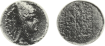
Sames I, was the Orontid king of Sophene, Armenia and Commagene, ruling around 260 BC.
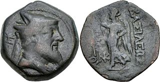
Xerxes was king of Sophene and Commagene from 228 BC to 212 BC. He was the son and successor of Arsames I.
Antiochus III Epiphanes was the ruler of the Kingdom of Commagene from 12 BC to 17 AD. He was the son and successor of King Mithridates III of Commagene and Iotapa, and of mixed Iranian, Armenian, Greek and Median descent – the last through his mother. His parents were first cousins.
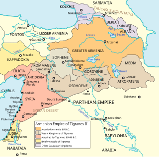
The Kingdom of Sophene, was a Hellenistic-era political entity situated between ancient Armenia and Syria. Ruled by the Orontid dynasty, the kingdom was culturally mixed with Greek, Armenian, Iranian, Syrian, Anatolian and Roman influences. Founded around the 3rd century BCE, the kingdom maintained independence until c. 95 BCE when the Artaxiad king Tigranes the Great conquered the territories as part of his empire. Sophene laid near medieval Kharput, which is present day Elazığ.

Orontes II was a Persian noble living in the 4th century BC. He is probably to be identified as the satrap of Armenia under Darius III, and may in fact have succeeded Darius in this position when Darius ascended the throne of Persia in 336 BC.

Orontes IV was the son of King Arsames and is recorded as ruling Armenia from inscriptions found at the historic capital of the Orontid dynasty, Armavir. He was the founder of the city of Yervandashat and Ervandakert. In his reign the religious site of Bagaran was founded. Large bronze statues in the Hellenistic style of the gods, Zeus (Aramazd), Artemis (Anahit) and Herakles (Vahagn) were brought there and set up in temples dedicated to them. He is also said to have founded a shrine at Armavir dedicated to Apollo (Mithra), a golden statue of four horses pulling a chariot with Apollo as god of the Sun. This was later destroyed by the Sassanid Persian army in the 4th century AD.

The Bagratuni or Bagratid dynasty was an Armenian royal dynasty which ruled the medieval Kingdom of Armenia from c. 885 until 1045. Originating as vassals of the Kingdom of Armenia of antiquity, they rose to become the most prominent Armenian noble family during the period of Arab rule in Armenia, eventually establishing their own independent kingdom. Their domain included regions of Armenia such as Shirak, Bagrevand, Kogovit, Syunik, Lori, Vaspurakan, Vanand and Taron. Many historians, such as Cyril Toumanoff, Nicholas Adontz and Ronald Suny, consider them to be the progenitors of the Georgian royal Bagrationi dynasty.