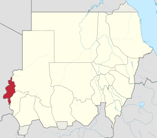
West Darfur State is one of the states of Sudan, and one of five comprising the Darfur region. Prior to the creation of two new states in January 2012, it had an area of 79,460 km² and an estimated population of approximately 1,007,000 (2006). It borders North and Central Darfur to the east. The Chadian prefectures of Biltine and Ouaddaï lie to the west, while to the north is the prefecture of Bourkou-Ennedi-Tibesti. Al-Junaynah is the capital of the state. West Darfur has been the site of much of the ongoing Darfur conflict.

Borkou-Ennedi-Tibesti Prefecture was the largest of the 14 prefectures of Chad between 1960 and 1999. It was transformed into Borkou-Ennedi-Tibesti Region, one of the 18 regions into which the country has been divided since 2002. Its name is often abbreviated to BET.

The Ennedi Plateau, located in the northeast of Chad, in the regions of Ennedi-Ouest and Ennedi-Est, is a sandstone bulwark in the middle of the Sahara. It covers an area of approximately 60,000 km2 (23,000 sq mi), and its highest point is approximately 1,450 m (4,760 ft) above sea level. The landscape has geological structures like towers, pillars, bridges and arches, which are big tourist attractions.
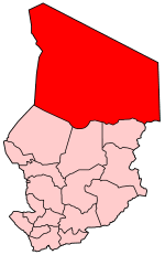
The Borkou-Ennedi-Tibesti (BET) was until 2008 one of the then 18 regions of Chad, its capital being Faya-Largeau. It comprised the former Borkou-Ennedi-Tibesti Prefecture. Most of the region was part of the Sahara desert.

The administrative divisions of Chad have often changed since 1900, when the territory was first created by France as part of its colonial empire, with the name Territoire Militaire des pays et protectorats du Tchad. The first subdivision took place in 1910, when 9 circonscriptions were made, named départements (departments) in 1935 and régions (regions) in 1947. As for the regions, they were further divided in districts.
Borkou is one of two departments of the Borkou Region in Chad. It was established by Ordinance No. 002/PR/08 of 19 February 2008. Its capital is Faya-Largeau.
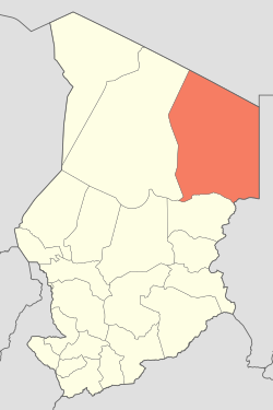
Ennedi Est was a department of the former Borkou-Ennedi-Tibesti region in Chad. Its capital was Bahaï.
Ennedi Ouest was a department of the former Borkou-Ennedi-Tibesti region in Chad. Its capital was Fada.
Tibesti was one of four departments within the former Bourkou-Ennedi-Tibesti region of Chad. Its capital was Bardaï.

Ennedi Region was a former region of Chad. It was created in 2008 from the Ennedi Est Department and Ennedi Ouest Department of the former Borkou-Ennedi-Tibesti Region. The capital of the Ennedi region was Fada. In 2012 it was split into two new regions: the department of Wadi Hawar became Ennedi-Est Region and the department of Ennedi became Ennedi-Ouest Region.

Tibesti Region is a region of Chad. It was created in 2008 when the former Borkou-Ennedi-Tibesti Region was split into three, with the Tibesti Department becoming the Tibesti Region. The Ennedi Region and Borkou Region were also created at that time. This region lies in the Sahara.
Ouaddaï Highlands is an area in east of Chad along the border with Sudan. The Ennedi Plateau and the Ouaddaï highlands in the east of Chad complete the image of a gradually sloping basin, which descends towards Lake Chad. There are also central highlands in the Guera region rising to 1,500 m (4,921 ft).

Ennedi-Est Region is a region of Chad which was created in 2012 from Ennedi Region. It appears to cover the same territory as the former Ennedi Est Department. The capital of the region is Am-Djarass. The region's current governor is General Hassan Djorobo.

Ennedi-Ouest Region is a region of Chad created in 2012 from the western half of Ennedi Region. It appears to cover the same territory as the former Ennedi Ouest Department. The capital of the region is Fada.
Kaoura is a small town in Ennedi Est department of Chad. It is located in the Ennedi Region, which was formed in 2008 from the Ennedi Est and Ennedi Ouest departments of the former Bourkou-Ennedi-Tibesti region. In 2009, the population of Kaoura was 15,093, 8,257 of which were male and 6,836 were female.
Wadi Hawar is a departments of Ennedi Region in Chad. It was created by Order No. 002 / PR / 08 of 19 February 2008. Its chief town is Amdjarass.