Kakheti is a region of Georgia. Telavi is its administrative center. The region comprises eight administrative districts: Telavi, Gurjaani, Qvareli, Sagarejo, Dedoplistsqaro, Signagi, Lagodekhi and Akhmeta.

Georgia is one of the oldest wine-producing countries in the world. The fertile valleys and protective slopes of the South Caucasus were home to grapevine cultivation and neolithic wine production for at least 8000 years. Due to millennia of winemaking and the prominent economic role it retains in Georgia to the present day, wine and viticulture are entwined with Georgia's national identity.

Gurjaani is a town in Kakheti, a region in eastern Georgia, and the seat of the Gurjaani Municipality. It is located in the Alazani River Plain, at an elevation of 415 m above sea level.

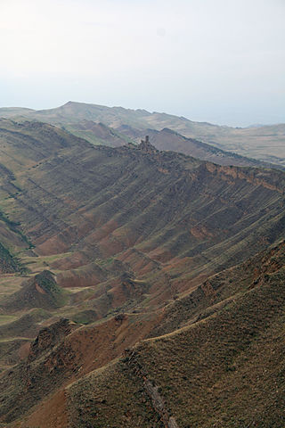
Kardenakhi (კარდანახი), also referred to as Kardenakh, is a village in Georgia, in Gurjaani Municipality in Kakheti region. It is located 510 meters above sea level on the northeastern slope of the Tsiv-Gombori Range, on the Bakurtsikhe-Tsnori highway, 14 kilometers from Gurjaani. According to the 2014 census, 3873 people live in the village.

Akhasheni is an appellation for wines produced around Akhasheni village, Gurjaani district, Kakheti region in eastern Georgia.

Gurjaani is an administrative-territorial unit in eastern Georgia, Kakheti region. Until 1917, the territory of Gurjaani municipality was part of Telavi Mazra of Tbilisi Governorate; since 1921 it has been included in Telavi Mazra; Since 1930, it has been an independent district in Kakheti region, then it became a separate district. It has been a municipality since 2006.
Sagarejo is a municipality of Georgia, in the region of Kakheti. Its main town is Sagarejo.

Sighnaghi is an administrative-territorial unit in eastern Georgia, Kakheti region. The municipality borders the municipalities of Gurjaani and Sagarejo to the northwest and west, the municipality of Dedoplistskaro to the southeast and the municipality of Lagodekhi and the Republic of Azerbaijan to the north and northeast. The area is 1251.7 km2. Agricultural fields occupy 93,375 ha, and forest resources amount to 5,500 ha.

Kvareli is an administrative-territorial unit in eastern Georgia, in the northeastern part of the Kakheti region. Until 1917, the territory of Qvareli Municipality was included in Telavi Mazra of Tbilisi Governorate; with the administrative division of 1921, the territory of Qvareli Municipality was again assigned to Telavi Mazra. Since 1930, it has been formed as a separate district. Currently, it is a municipality. The city of Qvareli, located at the confluence of the Bursa and Duruji rivers, has been a city since 1964.
Bakhtrioni is a ruined 17th-century fortress in the eastern Georgian region of Kakheti, on the left bank of the Alazani river near its confluence with the Ilto. The fortress served as a Safavid Iranian outpost in the 1650s until the rebellious Georgians captured and demolished it. Only insignificant ruins of the Bakhtrioni fortress have survived.

Georgia's road network plays an important role in both domestic and international traffic with the four neighboring countries. This is expressed in the road numbering system. The country has a network of 13 internationally oriented trunk highways that connect the capital Tbilisi, home to about a third of the national population, with its four neighboring countries. This is also the backbone of a network of domestic oriented national roads connecting vital regions with each other.

Velistsikhe is a village in Georgia. It is located in the Gurjaani Municipality of Kakheti. In 2014, its population was 4,508. It is located 380 metres (1,250 ft) above sea level.

The Georgian S5 route, also known as Tbilisi-Bakurtsikhe-Lagodekhi or Kakheti Highway, is a "road of international importance" within the Georgian road network and runs from Tbilisi via Sagarejo and Bakurtsikhe to the border with Azerbaijan near Lagodekhi over a distance of 160 kilometres (99 mi). After crossing the Georgian-Azerbaijan border the highway continues as M5 to Zagatala and Yevlakh. The S5 highway is one of the two Georgian S-highways that is not part of the European or Asian international highway routes. Within the Georgian S-network it connects with the S9 Tbilisi Bypass.
Vazisubani is a village in Gurjaani Municipality, Kakheti region, Georgia. It is located 14 km north-west of Gurjaani, at an altitude of about 500 m. The population was 2,862 inhabitants in 2014.
Akhasheni is a village in Gurjaani Municipality, Kakheti region, Georgia. It is located 8 km north-west of Gurjaani, at an altitude of about 460 m. The population was 2,420 inhabitants in 2014.
Ziari is a village in Gurjaani Municipality, Kakheti region, Georgia. It is located 5 km south-west of Gurjaani, at an altitude of about 820 m. The population was 44 inhabitants in 2014.

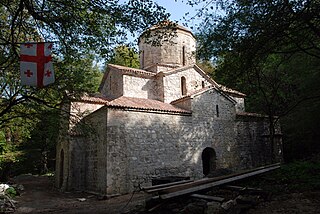
The Gurjaani Kvelatsminda Church of the Dormition of the Mother of God is a Georgian Orthodox church constructed in the 8th or 9th century, during the "transitional period" in the medieval Georgian architecture. It is located in the town of Gurjaani in Georgia's easternmost region of Kakheti.
The Vachnadziani All Holy, or Vachnadziani monastery is an old monastery Georgian Orthodox near the Vachnadziani village in the Gurjaani Municipality, eastern of Georgia. The main church of the named after All Saints monastery was the Mother Church of the 9th century.
Sanagire or monastery of Saint George is a Georgian orthodox medieval monastery in the Kakheti region, Georgia. It is located in the Gurjaani Municipality, six kilometers from the town of Vazisubani.

FC Alazani Gurjaani is a defunct Georgian association football club based in Gurjaani in Georgia, founded in 1964 during the Soviet Union.