
Blue Ridge is a city in Fannin County, Georgia, United States. As of the 2020 census, the city had a population of 1,253. The city is the county seat of Fannin County and the largest city in the county.
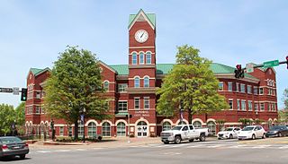
Cumming is a city in and the county seat of Forsyth County, Georgia, United States, and the sole incorporated area in the county. It is a suburban city, and part of the Atlanta metropolitan area. In the 2020 census, the population is 7,318, up from 5,430 in 2010. Surrounding unincorporated areas with a Cumming mailing address have a population of approximately 100,000.

Forsyth is a city in and the county seat of Monroe County, Georgia, United States. The population was 4,384 at the 2020 census, up from 3,788 in 2010. Forsyth is part of the Macon metropolitan statistical area.

The Chattahoochee River is a river in the Southeastern United States. It forms the southern half of the Alabama and Georgia border, as well as a portion of the Florida and Georgia border. It is a tributary of the Apalachicola River, a relatively short river formed by the confluence of the Chattahoochee and Flint rivers and emptying from Florida into Apalachicola Bay in the Gulf of Mexico. The Chattahoochee River is about 430 miles (690 km) long. The Chattahoochee, Flint, and Apalachicola rivers together make up the Apalachicola–Chattahoochee–Flint River Basin. The Chattahoochee makes up the largest part of the ACF's drainage basin.

The Etowah River is a 164-mile-long (264 km) waterway that rises northwest of Dahlonega, Georgia, north of Atlanta. On Matthew Carey's 1795 map the river was labeled "High Town River". On later maps, such as the 1839 Cass County map, it was referred to as "Hightower River", a name that was used in most early Cherokee records.

Noonday Creek is a 20.2-mile-long (32.5 km) stream in Cobb and Cherokee counties in the U.S. state of Georgia. The stream begins near Kennesaw Mountain and ends at Lake Allatoona.
The Chestatee River is a 32.76-mile-long (52.72 km) river in the Appalachian Mountains of northern Georgia, US.
Big Creek is a census county division in Forsyth County, Georgia, United States. It is the largest locale in the county in terms of population.

The Little River is a 29.3-mile-long (47.2 km) tributary of the Etowah River in the U.S. state of Georgia in the United States.
Georgia's 7th congressional district is a congressional district in the U.S. state of Georgia. It is currently represented by Republican Rich McCormick.

Coal Mountain is an unincorporated community in Forsyth County, Georgia, United States. The Coal Mountain area lies at the intersection of GA-369 and SR-9. It was once home to a post office that served the small community. North Forsyth High School, North Forsyth Middle School, Coal Mountain Elementary School, Coal Mountain Park, Coal Mountain Baptist Church, Mountain Lake Church, Regions Bank Coal Mountain are all located in Coal Mountain. It lies at an elevation of 1220 feet.

Willeo Creek is a 6.7-mile-long (10.8 km) stream in the U.S. state of Georgia, and is located in the north-northwestern part of metro Atlanta. It is a significant tributary of the Chattahoochee River, into which it flows at Bull Sluice Lake, just upstream from Morgan Falls Dam and downstream from the Chattahoochee Nature Center. Together, the two streams form nearly all of the county line between Fulton to the east and Cobb to the west.
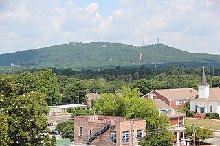
Sawnee Mountain is a low mountain between the piedmont and Appalachian foothills of the U.S. state of Georgia, north of Atlanta. Average rainfall/46.26in/yr/ average snowfall/5.7in/yr/. The name Sawnee Mountain actually refers to the entire ridge of approximately five miles (8 km) in length. At its summit, the elevation is 1,946 feet (593 m) above mean sea level, and is roughly 750 feet (230 m) above the surrounding terrain. The Sawnee Mountain range runs southwest to northeast, and consists of five knolls and three gaps. Located only a few miles north of Cumming, Georgia, the mountain is the highest point in Forsyth county at 1,946 ft above sea level. One of the highest peaks of metro Atlanta, it is taller than its more well-known neighbors Stone Mountain and Kennesaw Mountain by 260 ft and 138 ft respectively. Compared to other mountains in the area, however, Sawnee Mountain sits behind Bear Mountain and Pine Log Mountain, both in neighboring Cherokee County to the west.
Stamp Creek is a stream in the U.S. state of Georgia. It empties into Lake Allatoona.
Thompson Creek is a stream in Georgia, and is a tributary of the Chestatee River. The creek is approximately 1.86 miles (2.99 km) long.
Taylor Creek is a stream in Georgia, and is a tributary of the Chestatee River. The creek is approximately 3.66 miles (5.89 km) long.
Black Oak Creek is a stream in Cass and Henry counties in the U.S. state of Missouri. It is a tributary of Knob Creek.
Mill Creek is a stream in southern Miller County in the U.S. state of Missouri. It is a tributary of Grandglaize Creek.
Young Deer Creek is a stream in Forsyth County in the U.S. state of Georgia. It is a tributary to the Chattahoochee River.
