Baldwin Hills/Crenshaw, Los Angeles

Last updated
Baldwin Hills/Crenshaw
Map-Baldwin Hills-Crenshaw-district-of-Los Angeles.png
Map of the Baldwin Hills/Crenshaw neighborhood of Los Angeles,
as delineated by the Los Angeles Times
Location map Western Los Angeles.png
Red pog.svg
Baldwin Hills/Crenshaw
Location within Central Los Angeles
Coordinates: 34°1′12.15″N118°21′23.81″W / 34.0200417°N 118.3566139°W / 34.0200417; -118.3566139
Country Flag of the United States.svg  United States
State Flag of California.svg  California
City Los Angeles
Area code 323

Baldwin Hills/Crenshaw is a neighborhood in the south region of the city of Los Angeles defined by the Mapping L.A. project of the Los Angeles Times in 2009. [1] It combines the upscale, principally home-owning Baldwin Hills residential district to the south and the more concentrated apartment area of the Crenshaw district to the north.

Contents

History

19th century

Geography

Description

According to the 2009 Mapping L.A. project of the Los Angeles Times, Baldwin Hills/Crenshaw is bounded by Culver City, Jefferson Park, Ladera Heights, View Park-Windsor Hills and West Adams. Areas within it are Baldwin Village, Baldwin Vista, The Dons and Village Green. [1] [5] The neighborhood limits, according to Mapping L.A, are Jefferson Boulevard on the north, Ballona Creek, Jefferson Boulevard and La Brea Avenue on the west, the Kenneth Hahn State Recreation Area and Stocker Street on the south and Crenshaw Boulevard on the east. [1]

A commercial corridor along Crenshaw Boulevard includes Baldwin Hills Crenshaw Plaza, Marlton Square and Crenshaw Boulevard. [1]

Neighborhoods

Baldwin Hills/Crenshaw contains several neighborhoods: [5]

Population

The 2000 U.S census counted 30,123 residents in Baldwin Hills/Crenshaw and its area of 2.88 square miles gave it a population density of 10,446 people per square mile, about average for Los Angeles and the county as a whole. In 2008 the city estimated that 32,234 people lived there. The median age was 36, older than the city as a whole. The percentage of residents aged 65 and older was among the county's highest. [1]

The neighborhood was considered "moderately diverse" [7] in 2000, with 71.3% of residents being of black or African-American ancestry, 17.3% Latino, 4.7% Asian, 3.3% white and 3.4% of other backgrounds. The neighborhood had the fifth-highest concentration of black residents in the city. [1] [8]

The average household size was 2.3 people, low compared to the city as a whole. Almost 32% of the 2,400 families living in Baldwin Hills-Crenshaw were headed by single parents, [1] the third-highest rate in the city, after Watts and Vermont Knolls. [9]

The median household income at $37,948 in 2008 dollars was low compared with both city and county populations. The percentage of households earning $20,000 or less a year was high for the county. The percentage of residents 25 and older with a high school education and some college was high for the county, Those with a college degree were about the same as the rest of the city and county. [1]

The large number of veterans, 2,272 or 10.2% of the population, was high for both the city and the county. The percentage of veterans who served during World War II or the Korean War was among the county's highest. [1]

Only 16.6% of the residents were foreign born, a low figure for both the city and the county. Mexico (31%) and El Salvador (16.8%) were the most common foreign places of birth. [1]


Parks and recreation

View of Hollywood Hills (lower eastern Santa Monica Mountains) and tall San Gabriel Mountains from Baldwin Hills from the Baldwin Hills Scenic Overlook Park. Mountain view from Baldwin Hills.jpg
View of Hollywood Hills (lower eastern Santa Monica Mountains) and tall San Gabriel Mountains from Baldwin Hills from the Baldwin Hills Scenic Overlook Park.

Government

The Los Angeles Fire Department Station 94 serves the neighborhood.

Education

Baldwin Hills Elementary School Baldwin Hills Elementary School LAUSD 2023 April 01.jpg
Baldwin Hills Elementary School

Los Angeles Unified School District operates Baldwin Hills Elementary School. [16] New LA Elementary School, a charter school, is on the grounds of Baldwin Hills Elementary. A California law called Proposition 39 allows New LA to occupy space on the grounds of Baldwin Hills Elementary. In 2022 there were area community members that advocated for the charter school to move to another location since they believed that it meant there would not be enough space for the public elementary to operate efficiently. [17]

Notable people

See also

Related Research Articles

<span class="mw-page-title-main">View Park–Windsor Hills, California</span> Unincorporated community in California, United States

View Park−Windsor Hills is an unincorporated community in Los Angeles County, California. The View Park neighborhood is the community surrounding Angeles Vista Boulevard and the Windsor Hills neighborhood is on the southern end to the north of Slauson Avenue.

<span class="mw-page-title-main">Fairfax Avenue</span> Street in the city of Los Angeles, California

Fairfax Avenue is a street in the north central area of the city of Los Angeles, California, United States. It runs from La Cienega Boulevard in Culver City at its southern end to Hollywood Boulevard in Hollywood on its northern end. From La Cienega Boulevard to Sunset Boulevard, it separates the Westside from the central part of the city along with Venice Boulevard, La Cienega Boulevard, Hauser Boulevard, San Vicente Boulevard, South Cochran Avenue, Wilshire Boulevard, 6th Street, Cochran Avenue, 4th Street, La Brea Avenue, Fountain Avenue and Sunset Boulevard.

<span class="mw-page-title-main">Eagle Rock, Los Angeles</span> Neighborhood of Los Angeles in California, United States of America

Eagle Rock is a neighborhood of Northeast Los Angeles, abutting the San Rafael Hills in Los Angeles County, California. The community is named after Eagle Rock, a large boulder whose shadow resembles an eagle. Eagle Rock was once part of the Rancho San Rafael under Spanish and Mexican governorship. In 1911, Eagle Rock was incorporated as a city, and in 1923 it was annexed by Los Angeles.

<span class="mw-page-title-main">Sun Valley, Los Angeles</span> Neighborhood of Los Angeles in California, United States

Sun Valley is a neighborhood in Los Angeles, California in the San Fernando Valley region. The neighborhood is known for its overall youthful population and moderate racial diversity. There are three recreation centers in Sun Valley, one of which is a historic site. The neighborhood has thirteen public schools—including John H. Francis Polytechnic High School and Valley Oaks Center for Enriched Studies (VOCES)—and four private schools.

<span class="mw-page-title-main">Westchester, Los Angeles</span> Neighborhood of Los Angeles in the United States

Westchester is a neighborhood in the City of Los Angeles and the South Bay Region of Los Angeles County, California.

<span class="mw-page-title-main">West Hills, Los Angeles</span> Neighborhood in Los Angeles, California, United States

West Hills is an affluent residential community in the western San Fernando Valley region of the City of Los Angeles, California. The percentage of residents aged 35 and older is among the highest in Los Angeles County.

West Los Angeles is an area within the city of Los Angeles, California, United States. The residential and commercial neighborhood is divided by the Interstate 405 freeway, and each side is sometimes treated as a distinct neighborhood, mapped differently by different sources. Each lies within the larger Westside region of Los Angeles County.

<span class="mw-page-title-main">Rancho Park, Los Angeles</span> Neighborhood of Los Angeles in California, United States

Rancho Park is a residential neighborhood in the Westside of the city of Los Angeles, California with mostly single family homes and tree lined streets. The community is nestled between West Los Angeles and Cheviot Hills. This enclave draws young professionals and families and is home to residents working in a variety of professional occupations. History proves the neighborhood was once a part of Westwood until Olympic Blvd. was placed dividing the area North and South. The Southern section, now known as Rancho Park, felt cut off from its North side lobbying for its own identity in the 1930s.

<span class="mw-page-title-main">Baldwin Hills, Los Angeles</span> Neighborhood of Los Angeles in California, United States

Baldwin Hills is a neighborhood within the South Los Angeles region of Los Angeles, California.

<span class="mw-page-title-main">La Cienega Boulevard</span> Highway in California

La Cienega Boulevard is a major north–south arterial road in the Los Angeles metropolitan area that runs from El Segundo Boulevard in Hawthorne to the Sunset Strip in West Hollywood to the north. It was named for Rancho Las Cienegas, literally "The Ranch Of The Swamps," an area of marshland south of Rancho La Brea.

<span class="mw-page-title-main">Crenshaw Boulevard</span> Major street in Los Angeles

Crenshaw Boulevard is a north-south thoroughfare in Los Angeles, California, United States, that runs through Crenshaw and other neighborhoods along a 23-mile route in the west-central part of the city.

<span class="mw-page-title-main">Jefferson Park, Los Angeles</span> Neighborhood of Los Angeles in California, United States

Jefferson Park is a neighborhood in the South Los Angeles region of the City of Los Angeles, California. There are fourteen Los Angeles Historic-Cultural Monuments in the neighborhood, and in 1987, the 1923 Spanish Colonial Revival Jefferson Branch Library was added to the National Register of Historic Places. A portion of the neighborhood is a designated Historic Preservation Overlay Zone (HPOZ).

<span class="mw-page-title-main">Del Rey, Los Angeles</span> Neighborhood of Los Angeles in California, United States of America

Del Rey is a neighborhood in the Westside of Los Angeles, surrounded on three sides by Culver City, California. Within it lie a police station, the largest public housing complex on the Westside, a public middle school and six public elementary schools. It is served by a neighborhood council and a residents association. Del Rey, with a 32,000+ population, has a large number of military veterans.

Mid-Wilshire is a neighborhood in the central region of Los Angeles, California. It is known for the Los Angeles County Museum of Art, the Petersen Automotive Museum, and the Miracle Mile shopping district.

<span class="mw-page-title-main">Mid City, Los Angeles</span> Neighborhood of Los Angeles in California, United States of America

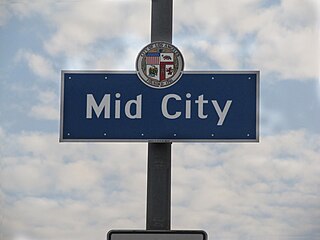
Mid City is a neighborhood in Central Los Angeles, California.

<span class="mw-page-title-main">Baldwin Vista, Los Angeles</span> Neighborhood of Los Angeles in County of Los Angeles, California, United States

Baldwin Vista is a neighborhood located next to the Baldwin Hills Mountains in the South region of the city of Los Angeles, California. It is located in the western Baldwin Hills, and partially borders on Culver City.

<span class="mw-page-title-main">Kenneth Hahn State Recreation Area</span> State recreation area in Los Angeles County, California, United States

Kenneth Hahn State Recreation Area, or Kenneth Hahn Park, is a state park unit of California in the Baldwin Hills Mountains of Los Angeles. The park is managed by the Los Angeles County Department of Parks and Recreation. As one of the largest urban parks and regional open spaces in the Greater Los Angeles Area, many have called it "L.A.'s Central Park". The 401-acre (1.62 km2) park was established in 1984. The land hs previously been the Baldwin Hills Dam, which catastrophically collapsed in 1963.

<span class="mw-page-title-main">Baldwin Hills (mountain range)</span> Mountain range in Los Angeles County, California, United States

The Baldwin Hills are a low mountain range surrounded by and rising above the Los Angeles Basin plain in central Los Angeles County, California. The Pacific Ocean is to the west, the Santa Monica Mountains to the north, Downtown Los Angeles to the northeast, and the Palos Verdes Hills to the south—with all easily viewed from the Baldwin Hills.

<span class="mw-page-title-main">Rancho La Ciénega ó Paso de la Tijera</span> Pre-statehood California land grant

Rancho La Ciénega ó Paso de la Tijera was a 4,219-acre (17.07 km2) Mexican land grant in present day Los Angeles County, California given in 1843 by Governor Manuel Micheltorena to Vicente Sánchez. "La Cienega" is derived from the Spanish word ciénega, which means swamp or marshland and refers to the natural springs and wetlands in the area between Beverly Hills and Park La Brea and the Baldwin Hills range.

President Barack Obama Boulevard is a major thoroughfare in South Los Angeles. It stretches 3.5 miles (5.6 km) from Baldwin Hills to Leimert Park.

References

  1. 1 2 3 4 5 6 7 8 9 10 "Baldwin Hills/Crenshaw," Mapping LA, Los Angeles Times
  2. 1 2 "Rancho La Cienega O'Paso de La Tijera". Laokay.com. Retrieved August 22, 2010.
  3. U.S. Geological Survey Geographic Names Information System: Rancho La Cienega o Paso de la Tijera
  4. "1932 Los Angeles Olympic Athlete's Village in the Baldwin Hills". Baldwinhillspark.info. Retrieved November 12, 2007.
  5. 1 2 "South L.A.," Mapping L.A., Los Angeles Times
  6. "Crenshaw Manor, Los Angeles, CA neighborhood | Nextdoor".
  7. Diversity "measures the probability that any two residents, chosen at random, would be of different ethnicities. If all residents are of the same ethnic group it's zero. If half are from one group and half from another it's .50." —Los Angeles Times
  8. "Black," Mapping L.A., Los Angeles Times
  9. "Single Parents," Mapping L.A., Los Angeles Times
  10. Baldwin Hills Scenic Overlook. accessed 8/22/2010
  11. "trail map" (PDF). Retrieved 2012-09-13.
  12. "Baldwin Hills Recreation Center Archived 2010-02-28 at the Wayback Machine ". City of Los Angeles. Retrieved on March 23, 2010.
  13. "Kenneth Hahn State Park". Parks.ca.gov. Retrieved August 22, 2010.
  14. "Norman O. Houston Park website". Laparks.org. Retrieved 2012-09-13.
  15. "Jim Gilliam Recreation Center website". Laparks.org. Retrieved 2012-09-13.
  16. "Home". Baldwin Hills Elementary School. Retrieved 2023-04-30.
  17. Mackey, Ashley (2022-10-20). "Community members protest charter school on Baldwin Hills Elementary School campus". ABC 7. Retrieved 2023-04-30.
  18. "Elfman in L.A." Elfman.filmmusic.com. Archived from the original on 2011-10-01. Retrieved 2011-01-02.
  19. Marrow, Tracy; Century, Douglas (2011). "Cold as Ice". Ice: A Memoir of Gangster Life and Redemption—from South Central to Hollywood . Random House. pp.  5–13. ISBN   978-0-345-52328-0.
  20. "Darryl Strawberry Statistics and History". Baseball-Reference.com. Retrieved 2012-05-23.
  21. Glicksman, Ben (December 21, 2010). "Crenshaw football star De'Anthony Thomas has Hollywood flair". Sports Illustrated.