
Heraklion or Iraklion is the largest city and the administrative capital of the island of Crete and capital of Heraklion regional unit. It is the fourth largest city in Greece with a municipal population of 177,064 and 211,370 in its wider metropolitan area. according to the 2011 census.

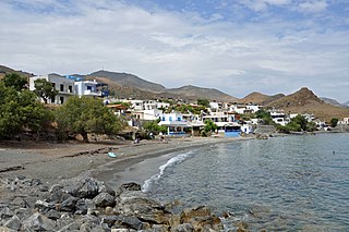
Myrtos is a coastal village in the west of the municipality of Ierapetra, in the Regional Unit of Lasithi on the Greek island of Crete. It is located 50 km (31 mi) from Agios Nikolaos and 15 km (9.3 mi) from Ierapetra, on the road to Viannos. A little to the west of the village is the iconic conical Kolektos mountain. Myrtos is situated on the Libyan Sea. The patron saint of the village is Saint Anthony. The population of the village in 2010 was approximately 600 people.

Gortyn, Gortys or Gortyna is a municipality, and an archaeological site, on the Mediterranean island of Crete 45 km (28 mi) away from the island's capital, Heraklion. The seat of the municipality is the village Agioi Deka. Gortyn was the Roman capital of Creta et Cyrenaica. The area was first inhabited around 7000 BC.
Lentas, Lentas is a coastal village 75 km south of Heraklion, on the south coast of Crete in Greece. It belongs to the community of Miamou within the municipality of Gortyna.
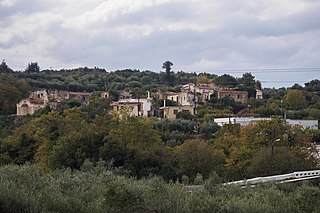
Xiro Chorio is a hamlet of approximately 170 residents, which is part of Rethymno (municipality)Rethymno municipality, capital of Rethymno regional unit in the island of Crete, Greece.

Gavalochori, also spelled Gavalohori, is a 1000-year-old village located in the northwestern part of the island of Crete, Greece. The village lies in a valley about three kilometers inland from the coast. Gavalochori is located in the municipality of Apokoronas and has a population of between 400 and 500, depending on the season.

Agia Pelagia is a popular seaside resort in the municipality of Malevizi, 23 km northwest of Crete's capital city of Heraklion. In former times, Agia Pelagia was a tiny fishing village and a place for the residents of nearby Achlada village to grow their crops. Today, the village built at the center of a picturesque amphitheatric bay has been transformed into a bustling tourist resort featuring five-star hotels, traditional seaside tavernas, cafes, bars, internet cafés, ATMs, and souvenir shops.

Xirosterni is a village and a community located in the Apokoronas region close to the northwest coast of the island of Crete, Greece, in Chania regional unit. The community consists of the settlements Xirosterni and Litsarda. It is approximately 25 kilometres (16 mi) from Chania.

The climate in Greece is predominantly Mediterranean. However, due to the country's geography, Greece has a wide range of micro-climates and local variations. The Greek mainland is extremely mountainous, making Greece one of the most mountainous countries in Europe. To the west of the Pindus mountain range, the climate is generally wetter and has some maritime features. The east of the Pindus mountain range is generally drier and windier in summer. The highest peak is Mount Olympus, 2,918 metres (9,573 ft). The northern areas of Greece have a transitional climate between the continental, the Mediterranean and the humid subtropical climate. There are mountainous areas that have an alpine climate. Also, various areas of Greece have semi-arid climates.

Loutro lies in the municipality of Sfakia, on the south coast of Chania regional unit in west Crete, between Chora Sfakion and Agia Roumeli, the exit to the Samaria Gorge. The whole area is known as Sfakia. The village got its name from the Greek word for "bath," for the many ancient baths found in the area.
Mourtzana is a village in Greece situated on the Old National Road Rethymno - Heraklion. It belongs to the community of Garazo in the municipal unit of Kouloukonas in Crete.

Greece is a country of the Balkans, in Southeastern Europe, bordered to the north by Albania, North Macedonia and Bulgaria; to the east by Turkey, and is surrounded to the east by the Aegean Sea, to the south by the Cretan and the Libyan seas, and to the west by the Ionian Sea which separates Greece from Italy.

The Razing of Kandanos refers to the complete destruction of the village of Kandanos in Western Crete (Greece) and the killing of about 180 of its inhabitants on 3 June 1941 by German occupying forces during World War II.

Greek National Road 90, also known as VOAK is the longest National Highway on the island of Crete, Greece. It runs along the north coast of the island Crete. It connects Kissamos in the west with Siteia in the east, via Chania, Rethymno, Heraklion and Agios Nikolaos.

Loutra is a medieval village of central Crete, Rethymno regional unit, Rethymno municipality, Arkadi municipal unit. It is situated 2 km from the Bay of Rethymno and 8 km from the town of Rethymno.
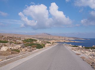
Sideros, is the outermost of a chain of two island-like peninsulas forming, with Itanos promontory, Cape Sidero. They are all three the summits of submarine elevations connected by rocky surface cols on which a road has been constructed to Cape Sidero Lighthouse, the elevated facsimile chapel of Saint Isidore, and Port Joannis, a cove of 2 fathoms (12 ft). There are ruins of an ancient temple of Athena destroyed by a tsunami and facilities of the Kyriamadi Naval Station. Kyriamadi is the other island-like peninsula in the chain. Administratively the cape lies within the Itanos municipal unit, Sitia Municipality, Lasithi regional unit, and Crete region.

The Museum of El Greco is located on the edge of the village of Fodele in Crete, west of the city of Heraklion. It celebrates the mannerist painter El Greco, who grew up in the village.
Korakias or Cape Korakias is a headland in northern Crete; the northwest extremity of the bay of Bali. It is identified with the ancient promontory called Dium or Dion. It has been supposed by some authors that the ancient city of Dium, spoken of by Pliny the Elder, was located near this headland.
Astale was a Roman town of ancient Crete. According to the Stadiasmus Maris Magni, it was located on the north coast of Crete, 30 stadia from an unknown location Amphimatrion (Άμφιματρίον), probably meaning Amphimalion, and 300 stadia from Herakleion. It was the harbour of Axus; excavations have taken place at the site.

Cyclone Ianos, also known as Medicane Ianos, was a rare Medicane that impacted the eastern Mediterranean on 17 and 18 September 2020, especially Greece. Ianos developed from an area of low pressure over the Gulf of Sidra that quickly began tropical cyclogenesis while moving over warm waters. After receiving various names from different meteorological centers, the storm, dubbed Ianos by the METEO unit of the National Observatory of Athens, rapidly intensified while moving northeastward. After scraping Italy, the storm went on to strike Malta and Crete with tropical storm-force winds. Despite land interaction, the small cyclone reached its peak intensity of 159 km/h (99 mph) with wind gusts up to 195 km/h (121 mph) on 18 September, equivalent to a Category 2 hurricane on the Saffir–Simpson scale, immediately before making landfall in southwestern Greece. After landfall, Ianos turned back out to sea and moved south-southeastward, before dissipating on 21 September.


