
Valais, sometimes Wallis, more formally the Canton of Valais, is one of the 26 cantons forming the Swiss Confederation. It is composed of thirteen districts and its capital and largest city is Sion. The flag of the canton is made of thirteen stars representing the districts, on a white-red background.
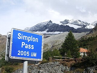
The Simplon Pass is a high mountain pass between the Pennine Alps and the Lepontine Alps in Switzerland. It connects Brig in the canton of Valais with Domodossola in Piedmont (Italy). The pass itself and the villages on each side of it, such as Gondo, are in Switzerland. The Simplon Tunnel was built beneath the vicinity of the pass in the early 20th century to carry rail traffic between the two countries.

The Albula Pass is a Swiss mountain pass in the canton of Graubünden. It lies at the heart of the Albula Alps, on the watershed between the Albula, tributary of the Rhine and the Ova d'Alvra, tributary of the Inn. Overlooking the pass are the ranges of Piz Üertsch (north) and Crasta Mora (south).

The Bernina Pass is a high mountain pass in the Bernina Range of the Alps, in the canton of Graubünden (Grisons) in eastern Switzerland. It connects the famous resort town of St. Moritz in the Engadin valley with the Italian-speaking Val Poschiavo, which ends in the Italian town of Tirano in Valtellina. The pass lies a few kilometres east of Piz Bernina, and south of Val Minor.

The Splügen Pass is an Alpine mountain pass of the Lepontine Alps. It connects the Swiss, Grisonian Splügen 5 kilometres (3.1 mi) to the north 675 metres (2,215 ft) below the pass with the Italian Chiavenna 21 kilometres (13 mi) to the south at the end of the Valle San Giacomo 1,789 metres (5,869 ft) below the pass.
The Flüela Pass is a high mountain pass of the Swiss Alps in Graubünden. Traditionally considered the boundary between the Albula and Silvretta Alps, the pass crosses the watershed / drainage divide between the basins of the Rivers Rhine and Danube. The pass is overlooked by the Flüela Schwarzhorn and the Flüela Wisshorn. The summit of the pass lies between the lakes Lai da la Scotta and Lai Nair.

Furka Pass, with an elevation of 2,429 metres (7,969 ft), is a high mountain pass in the Swiss Alps connecting Gletsch, Valais with Realp, Uri. The Furka Oberalp Bahn line through the Furka Tunnel bypasses the pass. The base tunnel opened in 1982 and replaced a tunnel at 2100 m.

Umbrail Pass is a high mountain pass on the Swiss-Italian border connecting Santa Maria in Val Müstair with Bormio in the Adda valley. On the Italian side, it connects to the Stelvio Pass road and the Valtellina. It is currently the highest paved road in Switzerland.

Pragel Pass is a high mountain pass in the Swiss Alps between the cantons of Schwyz and Glarus between Muotathal and Netstal. The pass itself is located in the canton of Schwyz.

Oberalp Pass is a high mountain pass in the Swiss Alps connecting the cantons of Graubünden and Uri between Disentis and Andermatt.

Susten Pass is a mountain pass in the Swiss Alps. The pass road, built from 1938–1945, connects Innertkirchen in the canton of Bern with Wassen in the canton of Uri. A 300-metre long tunnel crosses the pass at 2,224 metres.
San Bernardino Pass is a high mountain pass in the Swiss Alps connecting the Hinterrhein and the Mesolcina (Misox) valleys between Thusis and Bellinzona. Located in the far eastern side of the Western Alps it is not to be confused with the Great St Bernard Pass and the Little St Bernard Pass. The top of the pass represents both the Italo-German language frontier and the watershed between the Po basin and the Rhine basin. Marscholsee is within the pass at an elevation of 2,053 m (6,736 ft).

The Grosse Scheidegg is a mountain pass in the Bernese Alps of Switzerland, The pass crosses the col between the Schwarzhorn and the Wetterhorn mountains at an elevation of 1,962 m (6,437 ft).
Piz Kesch (German) or Piz d'Es-cha (Rumantsch) is a peak in the Albula Alps of the Rhaetian Alps in Switzerland. At 3,418 metres (11,214 ft), it is the highest peak in the Albula Alps and the municipality of Bergün, Grisons.
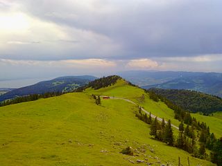
Chasseral Pass is a high mountain pass in the Jura Mountains, lying west of the Chasseral. The pass is located on the border between the Swiss cantons of Neuchâtel and Bern. It is traversed by a road connecting Saint-Imier and Nods, both located in the Bernese Jura. North-east of the pass is the Chasseral Ouest, the highest point of the canton of Neuchâtel.

Les Agites is a high mountain pass in the Alps in the canton of Vaud in Switzerland.
Passwang Pass is a high mountain pass in the Jura Mountains in the canton of Solothurn in Switzerland.

Sanetsch Pass is a high mountain pass in Switzerland across the western Bernese Alps, connecting Gsteig in the canton of Berne and Sion in the canton of Valais. Although a road leads to the pass from Sion and goes further to the Lac de Sanetsch, it can not be completely traversed by car. In the summer season the pass is accessible by PostBus and can also be traversed by cable car. The highest point of the road is at 2,252 metres.

