Related Research Articles

Rowe is a town in Franklin County, Massachusetts, United States. The population was 424 at the 2020 census.

Springfield is a town in Windsor County, Vermont, United States. As of the 2020 census, the population was 9,062.

Rutland is a town in Rutland County, Vermont, United States. As of the 2020 census, the population was 3,924. Rutland Town completely surrounds Rutland City, which is a separate municipality. The villages of the town effectively comprise the inner suburbs of Rutland City.

Ralph Edward Flanders was an American mechanical engineer, industrialist and politician who served as a Republican U.S. Senator from the state of Vermont. He grew up on subsistence farms in Vermont and Rhode Island and was an apprentice machinist and draftsman before training as a mechanical engineer. He spent five years in New York City as an editor for a machine tool magazine. After moving back to Vermont, he managed and then became president of a successful machine tool company. Flanders used his experience as an industrialist to advise state and national commissions in Vermont, New England and Washington, D.C., on industrial and economic policy. He was president of the Boston Federal Reserve Bank for two years before being elected U.S. Senator from Vermont.

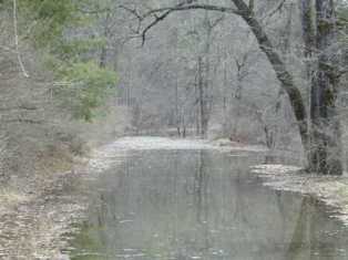
The Saxtons River is a 22.9-mile-long (36.9 km) river in the U.S. state of Vermont, a tributary of the Connecticut River. Its watershed covers 78 square miles (200 km2) and a range in altitude of 1,800 feet (550 m); land use is about 80% forested and 3% agricultural, and the upper river supports wild brook trout and brown trout, while Atlantic salmon occur but are usually limited to the area below Twin Falls on the lower river.
The Ompompanoosuc River is a river, about 25 mi (40 km) long, in eastern Vermont in the United States. It is a tributary of the Connecticut River, which flows to Long Island Sound. According to the Geographic Names Information System, the river has also been known by the names "Om-pom-pa-noos-uc" and "Pompanoosuc."
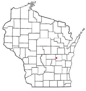
The Windsor-1-1 Representative District is a one-member state Representative district in the U.S. state of Vermont. It is one of the 108 one- or two-member districts into which the state was divided by the redistricting and reapportionment plan developed by the Vermont General Assembly following the 2000 U.S. Census. The plan applies to legislatures elected in 2002, 2004, 2006, 2008, and 2010. A new plan will be developed in 2012 following the 2010 U.S. Census.
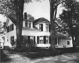
The Coolidge Homestead, also known as Calvin Coolidge Homestead District or President Calvin Coolidge State Historic Site, was the childhood home of the 30th president of the United States, Calvin Coolidge and the place where he first took the presidential oath of office. Located in Plymouth Notch, Vermont, Coolidge lived there from age four in 1876 to 1887, when he departed for Black River Academy for education. He is buried in Plymouth Notch Cemetery not far from the home.

The Black River is a 40.8-mile-long (65.7 km) river in the U.S. state of Vermont, and a tributary of the Connecticut River. The river's watershed consists of approximately 202 square miles (520 km2) in southeastern Vermont, almost all of which lies in Windsor County.
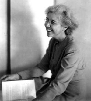
Helen Hartness Flanders, a native of the U.S. state of Vermont, was an internationally recognized ballad collector and an authority on the folk music found in New England and the British Isles. At the initiative of the Vermont Commission on Country Life, Flanders commenced a three-decade career capturing traditional songs that were sung in New England—songs that, in many cases, traced their origin to the British Isles. The timing of her life work was critical, coming as it did when people were turning away from traditional music in favor of listening to the radio. Today her nearly 4,500 field recordings, transcriptions and analyses are housed at the Flanders Ballad Collection at Middlebury College, Middlebury, Vermont and have been a resource for scholars and folk singers since the establishment of the collection in 1941.

The Williams River is a 27.0-mile (43.5 km) river in the US state of Vermont. It is a tributary of the Connecticut River. Its watershed covers 117 square miles; land use is about 80% forested and 4% agricultural, and the upper river supports wild brook trout and brown trout.
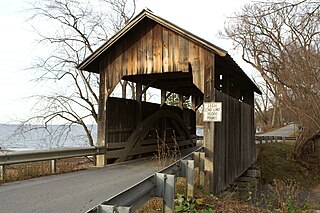
The Eureka Schoolhouse is a historic school building at 470 Charlestown Road in the Goulds Mill village of Springfield, Vermont. Built in 1785, it is the oldest surviving schoolhouse in the state. It is the centerpiece of a small historic site operated by the state. The school was listed on the National Register of Historic Places in 1971.
Delhi, Wisconsin is a ghost town in the town of Rushford, Winnebago County, Wisconsin, United States. It is located on County Highway E between Omro and Eureka at the junction of the Fox River and Waukau Creek. Delhi was also known as La Borde's Landing. 1890 census records identify Delhi as Island Park. Delhi had an established post office between 1850-1893.
The Holmes Creek Covered Bridge, also called the Lakeshore Covered Bridge, is a one-lane wooden covered bridge that crosses Holmes Creek in Charlotte, Vermont on Lake Road, adjacent to Charlotte Beach. It was listed on the National Register of Historic Places in 1974.

The Great Eddy Covered Bridge, also called the Big Eddy Covered Bridge or Waitsfield Covered Bridge, is a wooden covered bridge that crosses the Mad River in Waitsfield, Vermont on Bridge Street. Built in 1833, it is one of Vermont's oldest covered bridges. It was listed on the National Register of Historic Places in 1974.

The Dingleton Hill Covered Bridge, also known as the Cornish Mills Bridge, is a historic wooden covered bridge, carrying Root Hill Road over Mill Brook in Cornish Mills, New Hampshire. Built in 1882, it is one of the state's few surviving 19th-century covered bridges. It was listed on the National Register of Historic Places in 1978. It carries one lane of traffic, with a posted weight limit.

Terrible Mountain is a summit in Windsor County, Vermont, in the United States. With an elevation of 2,882 feet (878 m), Terrible Mountain is the 214th highest summit in the state of Vermont.

The Follett Stone Arch Bridge Historic District encompasses a group of four stone arch bridges in southwestern Townshend, Vermont. All four bridges were built by James Otis Follett, a local self-taught mason, between 1894 and 1910, and represent the single greatest concentration of surviving bridges he built. The district was listed on the National Register of Historic Places in 1976.

The Swanton Covered Railroad Bridge was a covered bridge in Swanton, Vermont. Built in 1898, it carried the St. Johnsbury and Lamoille County Railroad across the Missisquoi River just west of Swanton village. It was destroyed by fire in 1987, and its site is now occupied by the former West Milton Bridge. The bridge was listed on the National Register of Historic Places in 1973, and has not been delisted despite its destruction.
The West Milton Bridge is a steel girder bridge carrying Bear Trap Road across the Lamoille River in Milton, Vermont, United States. It was built as a replacement for a 1902 Pennsylvania truss bridge, which was relocated to the site of the Swanton Covered Railroad Bridge, and is listed on the National Register of Historic Places.
References
- ↑ "Vermont Covered Bridge Society, Covered Bridges, Covered Bridge News". www.vermontbridges.com.
- ↑ "Eureka Schoolhouse & Baltimore Covered Bridge | State Historic Sites".
- ↑ "Vermont Covered Bridge Society, Covered Bridges, Covered Bridge News". www.vermontbridges.org.
43°16′13″N72°26′54″W / 43.27030°N 72.44826°W
| | This article about a bridge in Vermont is a stub. You can help Wikipedia by expanding it. |