Related Research Articles

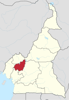
The Northwest Region, or North-West Region is one of ten regions in Cameroon. Its regional capitol is Bamenda. The Northwest Region is part of the Southern Cameroons, found in the western highlands of Cameroon. It is bordered to the southwest by the Southwest Region, to the south by the West Region, to the east by the Adamawa Region, and to the north by Nigeria. Various Ambazonian nationalist and separatist factions regard the region as being distinct as a polity from Cameroon.
The West Region is 14,000 km² of territory located in the central-western portion of the Republic of Cameroon. It borders the Northwest Region to the northwest, the Adamawa Region to the northeast, the Centre Region to the southeast, the Littoral Region to the southwest, and the Southwest Region to the west. The West Region is the smallest of Cameroon's ten regions in area, yet it has the highest population density.
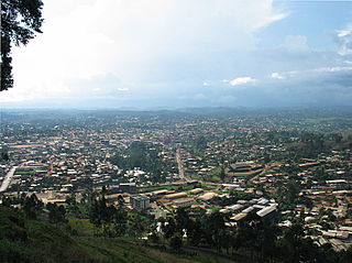
Bamenda, also known as Abakwa and Mankon Town, is a city in northwestern Cameroon and capital of the Northwest Region. The city has a population of about 2 million people and is located 366 kilometres (227 mi) north-west of the Cameroonian capital, Yaoundé. Bamenda is known for its cool climate and scenic hilly location.

Cameroon is a Central African nation on the Gulf of Guinea. Bantu speakers were among the first groups to settle Cameroon, followed by the Muslim Fulani until German domination in 1884. After World War I, the French took over 80% of the area, and the British 20%. After World War II, self-government was granted, and in 1972, a unitary republic was formed out of East and West Cameroon. Until 1976 there were two separate education systems, French and English, which did not merge seamlessly. French is now considered the primary language of instruction. Local languages are generally not taught as there are too many, and choosing between them would raise further issues.

The Bamileke are a Grassfields ethnic group. They make up the largest ethnic group in Cameroon and inhabit the country's western region. The Bamileke are subdivided into several tribes, each under the guidance of a King or fon. They speak a number of related languages from the Eastern Grassfields branch of the Grassfields language family.

Bafut is a town located in a modern commune in Cameroon, it is also a traditional fondom. It is located in the Mezam Department, which in turn is located in the Northwest Province.

Mankon is a geo-historic community constituting a large part of Bamenda in Cameroon, formed as an amalgamation of about five different ethnic groups. The Mankon fondom (kingdom) represents one of the oldest monarchies of the grassfield people of the Northwest Province. The fondom is ruled by a fon (king) with rights to kinghood acquired by birth. The crowned fon is usually a designated son of the deceased king, a child who was born only during his reign.
The Kom are one of the principal ethnic groups of the North-West province of Cameroon, where traditional government institutions are very important. The capital, Laikom, is the seat of the ruler, the Fon, and his advisors, the Quifon, who continue to be the most respected leaders despite the imposition of a central Cameroonian government. Vincent Yuh II died in November 2017, Fon Ndzi II is the current Fon of Kom. The Cameroonian government recognizes to some degree the authority of the Fons and local chiefs subject to them.
Dschang is a city located in the West (Ouest) Province of Cameroon, with an estimated population of 87,000 (est) in 2001, growing dramatically from 21,705 recorded in 1981. The 2006 Population is estimated to be 200,000 inhabitants. Dschang is the capital of the division of Ménoua. The Bamiléké are the predominant ethnic tribe.
The Nso are a people of the Bamenda grass fields Northwest Region of Cameroon. Their traditional language is Lamnso and their capital is Kumbo – where the Palace of the Fon is found.
The Bafut Subdivision or the Kingdom/Chiefdom/Fondom of Bafut is a commune in the Mezam Department of Northwest Province, Cameroon. It is located in the Western Grassfields region - a name for the Northwest Province and surrounding grassland areas. Bafut is the most powerful of the traditional kingdoms of the Grassfields, now divided into 26 wards along a 10 kilometre stretch of the "Ring Road" that trails along a ridge above the Menchum Valley.

The Western High Plateau, Western Highlands or Bamenda Grassfields is a region of Cameroon characterised by high relief, cool temperatures, heavy rainfall and savanna vegetation. The region lies along the Cameroon line and consists of mountain ranges and volcanoes made of crystalline and igneous rock. The region borders the South Cameroon Plateau to the southeast, the Adamawa Plateau to the northeast and the Cameroon coastal plain to the south.
Santchou is a town and commune in Cameroon.
The University of Bamenda (UBa) is an Anglo-Saxon university in Bamenda, North Western Cameroon.
Beba is a Fondom with several village communities that form part of the Benakuma sub-division in the Menchum Valley of the Northwest region of Cameroon. It is about 208 miles (335 km) from the capital city, Yaoundé. The village is accessible by a motorable road while footpaths are used to join distinct communities). Beba Fondom residents claim that their people originated from Widikum in Momo Division. They moved to Bamenda's Ntarinkon Quarter, then Mbengwi Village, later migrated to Ntamecheh and finally settled at their present location.
Sosthène Léopold Bayemi Matjei is a Cameroonian Roman Catholic bishop.

Balikumbat is a village located in Balikumbat Sub Division, Ngoketunjia Division of the North West Region, Cameroon. Balikumbat is the Sub Divisional Headquarter of Balikumbat Sub Division and located about 20.9 km from Ndop town.

Bamessing village is one of four villages that make up Ndop central Central Sub Division, and one of thirteen villages of Ngoketunjia division of the North West region of Cameroon. Bamessing is located along the ring road from Bamenda, some 38 km from the town of Bamenda, on the Bamenda-Nkambe stretch of the ring road, just before Bamunka.
Bamali village is one of the four villages that make up Ndop Central sub division and one of the thirteen villages of Ngoketunjia division of the North West region of Cameroon. Bamali village is located partly along the ring road from Bamenda some 40 km away from Bamenda town on the Bamenda-Nkambe stretch of the ring road just before reaching Bamunka.
Men Own the Fields, Women Own the Crops: Gender and Power in the Cameroon Grassfields is a 1996 anthropological book written by Miriam Goheen that collects observations made by Goheen during a sixteen year long stay with the Nso people of Cameroon. During this time she studied the gender and power dynamics between the elite class and the Nso women.
References
- ↑ "Tubah council baseline report Pg 13". EWB Challenge. Tubah Council. Archived from the original on 2 February 2016. Retrieved 26 January 2016.
- ↑ "History of Bambui Fondom". Archived from the original on 2012-04-25. Retrieved 2011-11-03.